
The Trans-Canada Highway is a transcontinental federal–provincial highway system that travels through all ten provinces of Canada, from the Pacific Ocean on the west coast to the Atlantic Ocean on the east coast. The main route spans 7,476 km (4,645 mi) across the country, one of the longest routes of its type in the world. The highway system is recognizable by its distinctive white-on-green maple leaf route markers, although there are small variations in the markers in some provinces.

The Pan-American Highway is a network of roads stretching across the Americas and measuring about 30,000 kilometres (19,000 mi) in total length. Except for a break of approximately 106 km (66 mi) across the border between northwest Colombia and southeast Panama called the Darién Gap, the roads link almost all of the Pacific coastal countries of the Americas in a connected highway system. According to Guinness World Records, the Pan-American Highway is the world's longest "motorable road". It is only possible to cross by land between South America and Central America—the last town in Colombia to the first outpost in Panama—by a difficult and dangerous hike of at least four days through the Darién Gap, one of the rainiest areas of the planet.

The Trans Canada Trail, officially named The Great Trail between September 2016 and June 2021, is a cross-Canada system of greenways, waterways, and roadways that stretches from the Atlantic to the Pacific to the Arctic oceans. The trail extends over 24,000 km (15,000 mi); it is now the longest recreational, multi-use trail network in the world. The idea for the trail began in 1992, shortly after the Canada 125 celebrations. Since then it has been supported by donations from individuals, corporations, foundations, and all levels of government.

Numbered highways in Canada are split by province, and a majority are maintained by their province or territory transportation department. All highways in Canada are numbered except for three in the Northwest Territories, one in Alberta, one in Ontario, and one in Quebec. Ontario's 7000 series are not marked with their highway number but have been assigned one by the Ministry of Transportation. A number of highways in all provinces are better known locally by their name rather than their number. Some highways have additional letters added to their number: A is typically an alternate route, B is typically a business route, and other letters are used for bypass (truck) routes, connector routes, scenic routes, and spur routes. The territory of Nunavut has no highways.

The Yellowhead Highway is a major interprovincial highway in Western Canada that runs from Winnipeg to Graham Island off the coast of British Columbia via Saskatoon and Edmonton. It stretches across the four western Canadian provinces of British Columbia, Alberta, Saskatchewan, and Manitoba and is part of the Trans-Canada Highway system and the larger National Highway System, but should not be confused with the more southerly, originally-designated Trans-Canada Highway. The highway was officially opened in 1970. Beginning in 1990, the green and white Trans-Canada logo was used to designate the roadway.
Highway 1 is a provincial highway in British Columbia, Canada, that carries the main route of the Trans-Canada Highway (TCH). The highway is 1,047 kilometres (651 mi) long and connects Vancouver Island, the Greater Vancouver region in the Lower Mainland, and the Interior. It is the westernmost portion of the main TCH to be numbered "Highway 1", which continues through Western Canada and extends to the Manitoba–Ontario boundary. The section of Highway 1 in the Lower Mainland is the second-busiest freeway in Canada, after Ontario Highway 401 in Toronto.
There are many roads in the southwestern part of British Columbia and Vancouver Island that were designated as Highway 1A. These roads were sections of the original 1941 route of Highway 1 before its various re-alignments, and are used today as service routes and frontage roads. The "B.C. Highway 1A" designations were removed from these sections by the province between 2005 and 2010, although signage remains along some of the route and the designation on some maps.

The Liard Highway is a 378 km two-lane highway in Canada that is the only direct road link between British Columbia and the Northwest Territories. Passing through sparsely-populated areas of boreal forest, it serves as the sole land access route for the communities of Fort Liard and Nahanni Butte.

King's Highway 17, more commonly known as Highway 17, is a provincially maintained highway and the primary route of the Trans-Canada Highway through the Canadian province of Ontario. It begins at the Manitoba boundary, 50 km (31 mi) west of Kenora, and the main section ends where Highway 417 begins just west of Arnprior. A small disconnected signed section of the highway still remains within the Ottawa Region between County Road 29 and Grants Side Road. This makes it Ontario's longest highway.
The Dempster Highway, also referred to as Yukon Highway 5 and Northwest Territories Highway 8, is a highway in Canada that connects the Klondike Highway in Yukon to Inuvik, Northwest Territories on the Mackenzie River delta. The highway crosses the Peel and the Mackenzie rivers using a combination of seasonal ferry services and ice bridges. Year-round road access from Inuvik to Tuktoyaktuk opened in November 2017, with the completion of the Inuvik–Tuktoyaktuk Highway, creating the first all-weather road route connecting the Canadian road network with the Arctic Ocean.

The Canol Road was part of the Canol Project and was built to construct a pipeline from Norman Wells, Northwest Territories, to Whitehorse, Yukon, during World War II. The pipeline no longer exists, but the 449 kilometres (279 mi) long Yukon portion of the road is maintained by the Yukon Government during summer months. The portion of the road that still exists in the NWT is called the Canol Heritage Trail. Both road and trail are incorporated into the Trans-Canada Trail.
The Mackenzie Highway is a Canadian highway in northern Alberta and the Northwest Territories. It begins as Alberta Highway 2 at Mile Zero in Grimshaw, Alberta. After the first 4.0 km (2.5 mi), it becomes Alberta Highway 35 for the balance of its length through Alberta and then becomes Northwest Territories Highway 1.
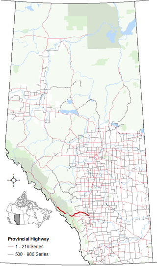
Alberta Provincial Highway No. 1A is the designation of two alternate routes off the Alberta portion of Trans-Canada Highway 1. However, it is not the only name used for spurs off Highway 1 - Highway 1X is another such designation. Despite these highways being suffixed routes of Highway 1, they are not part of the Trans-Canada Highway network, and are signed with Alberta's provincial primary highway shields instead of the Trans-Canada shields used for Highway 1.
Route 1 is a highway in the Canada province of Newfoundland and Labrador, and is the easternmost stretch of the Trans-Canada Highway. Route 1 is the primary east–west road on the island of Newfoundland.
Highway 1 is the Saskatchewan section of the Trans-Canada Highway mainland route. The total distance of the Trans-Canada Highway in Saskatchewan is 654 kilometres (406 mi). The highway traverses Saskatchewan from the western border with Alberta, from Highway 1, to the Manitoba border where it continues as PTH 1. The Trans-Canada Highway Act was passed on December 10, 1949. The Saskatchewan segment was completed August 21, 1957, and completely twinned on November 6, 2008. The speed limit along the majority of the route is 110 kilometres per hour (70 mph) with urban area thoroughfares slowing to a speed of 80–100 kilometres per hour (50–62 mph). Portions of the highway—the section through Swift Current, an 8-kilometre (5 mi) section east of Moose Jaw, and a 44-kilometre (27 mi) section between the West Regina Bypass and Balgonie—are controlled-access. Highway 1 serves as a major east–west transport route for commercial traffic. It is the main link between southern Saskatchewan's largest cities, and also serves as the province's main link to the neighbouring provinces of Alberta and Manitoba.

Highway 39 is a provincial, paved, highway located in the southern portion of the Canadian province of Saskatchewan connecting North Portal and Moose Jaw in the north. This is a primary Saskatchewan highway maintained by the provincial and national governments and providing a major trucking and tourism route between the United States via Portal, Burke County, North Dakota, and North Portal, Saskatchewan. On July 3, 2000, Highways and Transportation Minister Maynard Sonntag officiated at the ribbon cutting ceremony opening the new duty-free shop and the twinned highway at Saskatchewan's busiest border crossing. Highway 39 is one of Canada's busiest highways, facilitating transport for $6 billion in trade goods via approximately 100,000 trucks over the year. The entire length of highway 39 is paved. The CanAm Highway comprises Saskatchewan Highways Hwy 35, Hwy 39, Hwy 6, Hwy 3, as well as Hwy 2. 44.3 miles (71.3 km) of Saskatchewan Highway 39 contribute to the CanAm Highway between Weyburn and Corinne. Highway 39 is divided or twinned in two areas at North Portal as well as north of Weyburn for 1.7 kilometres (1.1 mi). The junction of Hwy 39 with the Trans–Canada divided four-lane highway is done via a "Parclo" or partial cloverleaf interchange.
The National Highway System in Canada is a federal designation for a strategic transport network of highways and freeways. The system includes but is not limited to the Trans-Canada Highway, and currently consists of 38,021 kilometres (23,625 mi) of roadway designated under one of three classes: Core Routes, Feeder Routes, and Northern and Remote Routes.
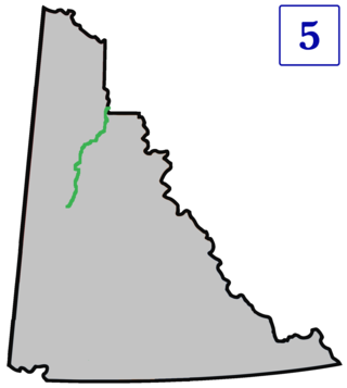
Alberta Provincial Highway No. 48, commonly referred to as Highway 48, has been the designation of two separate highways in Alberta's history. The first was a north–south highway in southern Alberta, Canada that existed between the 1950s and 1979. It now forms the southernmost portion of Highway 41. The current Alberta highway 48 connects to Northwest Territories Highway 5 at the Northwest Territories boarder in Fort Smith NWT to Fort Fitzgerald and Hay Camp Road. The road was chip sealed in July 2021.
 Newfoundland and Labrador Highway 1 between Veterans Memorial Highway and Peacekeepers Way, part of the Trans Canada Highway
  New Brunswick Route 2, part of the Trans Canada Highway
 Northwest Territories Highway 1, from the Alberta/Northwest Territories border to Enterprise, Northwest Territories [1]
  Nova Scotia Highway 111, also known as the Circumferential Highway ("The Circ")
 Ontario Highway 401 between Toronto and Trenton.
 Saskatchewan Highway 1 between Moose Jaw and Regina, part of the Trans Canada Highway