This is a list of historic places in Laurentides , entered on the Canadian Register of Historic Places, whether they are federal, provincial, or municipal. All addresses are the administrative Region 15. For all other listings in the province of Quebec, see List of historic places in Quebec.
| Name | Address | Coordinates | IDF | IDP | IDM | | Image |
|---|---|---|---|---|---|---|---|
| Calvaire d'Oka | , Oka , QC | 45°28′55″N74°03′54″W / 45.482°N 74.0649°W | 4863 |  More images | |||
| Cathédrale de Saint-Jérôme | Place du Cure-Labelle, Saint-Jérôme , QC | 45°46′41″N74°00′09″W / 45.778°N 74.0025°W | 15152 |  More images | |||
| Grange-écurie des Prêtres-Chaumont | 163, Boulevard Sainte-Anne, Sainte-Anne-des-Plaines , QC | 45°45′40″N73°48′52″W / 45.7611°N 73.8145°W | 5222 |  More images | |||
| Maison des Prêtres-Chaumont | 163, Boulevard Sainte-Anne, Sainte-Anne-des-Plaines, QC | 45°45′39″N73°48′51″W / 45.7609°N 73.8141°W | 5492 |  | |||
| Cimetière de Sainte-Anne-des-Plaines | 129, Boulevard Sainte-Anne, Sainte-Anne-des-Plaines, QC | 45°45′36″N73°49′00″W / 45.7601°N 73.8167°W | 8414 |  More images | |||
| Ancien couvent de Sainte-Anne-des-Plaines | 139, Boulevard Sainte-Anne, Sainte-Anne-des-Plaines, QC | 45°45′36″N73°48′56″W / 45.7601°N 73.8156°W | 8415 |  More images | |||
| Presbytère de Sainte-Anne-des-Plaines | 129, Boulevard Sainte-Anne, Sainte-Anne-des-Plaines, QC | 45°45′34″N73°48′56″W / 45.7594°N 73.8156°W | 8968 |  More images | |||
| Maison Joseph-Thibodeau | 757, Rue Principale, Piedmont , QC | 45°54′08″N74°08′17″W / 45.9021°N 74.1381°W | 4851 | | |||
| Gare ferroviaire de Saint-Faustin-Station | Allee du 7e, Mont-Blanc , QC | 46°07′46″N74°28′17″W / 46.1294°N 74.4713°W | 9846 | | |||
| Maison Adolphe-Basile-Routhier | 3320, Route 344, Saint-Placide , QC | 45°31′40″N74°13′04″W / 45.5278°N 74.2178°W | 5118 | | |||
| Maison Barclay | 36, Rue Principale, Saint-André-d'Argenteuil , QC | 45°33′55″N74°22′22″W / 45.5652°N 74.3729°W | 5124 |  More images | |||
| Carillon Barracks National Historic Site of Canada | 50 Principale Street, Carillon , QC | 45°34′07″N74°22′35″W / 45.5686°N 74.3765°W | 11123 7406 |  More images | |||
| Carillon Canal National Historic Site of Canada | 210 du Barrage Street, Carillon, QC | 45°34′06″N74°22′41″W / 45.5684°N 74.378°W | 11676 |  More images | |||
| Secteur Basile-Routhier | Route 344, Saint-Placide , QC | 45°31′34″N74°13′23″W / 45.5261°N 74.2231°W | 13478 | | |||
| Maison Garth | 100, Grande-Cote, Lorraine , QC | 45°39′15″N73°46′21″W / 45.6543°N 73.7724°W | 6980 |  More images | |||
| Chapelle du cimetière de Saint-Jérôme | Rue John-F.-Kennedy, Saint-Jérôme , QC | 45°46′38″N74°01′38″W / 45.7772°N 74.0272°W | 8947 |  More images | |||
| Maison Prévost | 349, Rue Labelle, Saint-Jérôme, QC | 45°46′39″N74°00′14″W / 45.7774°N 74.004°W | 3480 | | |||
| Ancien palais de justice de Saint-Jérôme | 101, Place du Cure-Labelle, Saint-Jérôme, QC | 45°46′43″N74°00′12″W / 45.7787°N 74.0032°W | 5639 | 8936 |  | ||
| Gare de Saint-Jérôme | 100, Place de la Gare, Saint-Jérôme, QC | 45°46′36″N74°00′02″W / 45.7767°N 74.0006°W | 7095 | 8938 | | ||
| Hôtel de ville de Saint-Jérôme | 280, Rue Labelle, Saint-Jérôme, QC | 45°46′32″N74°00′16″W / 45.7756°N 74.0045°W | 8939 | | |||
| Presbytère de Saint-Jérôme | 355, Place du Cure-Labelle, Saint-Jérôme, QC | 45°46′39″N74°00′10″W / 45.7776°N 74.0027°W | 11175 | | |||
| Charnier de Sainte-Agathe | 37, Rue Principale Est, Sainte-Agathe-des-Monts , QC | 46°02′45″N74°17′07″W / 46.0457°N 74.2854°W | 8986 | | |||
| Église de Sainte-Agathe | Rue Principale Est, Sainte-Agathe-des-Monts, QC | 46°02′45″N74°17′06″W / 46.0459°N 74.2851°W | 9020 |  More images | |||
| Presbytère de Sainte-Agathe | 37, Rue Principale Est, Sainte-Agathe-des-Monts, QC | 46°02′48″N74°17′09″W / 46.0467°N 74.2859°W | 14416 | | |||
| Site du patrimoine Beattie-des-Pins | Rue Beattie, Mont-Tremblant , QC | 46°07′44″N74°35′24″W / 46.1288°N 74.5901°W | 11250 |  | |||
| Chapelle Saint-Bernard | , Mont-Tremblant, QC | 46°12′38″N74°35′16″W / 46.2105°N 74.5878°W | 13268 | | |||
| Gare de Lachute | 540, Rue Berry, Lachute , QC | 45°39′22″N74°20′01″W / 45.6562°N 74.3337°W | 6720 | 8140 | 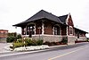 | ||
| Édifice centenaire de la municipalité régionale de comté d'Argenteuil | 430, Rue Grace, Lachute, QC | 45°39′13″N74°20′10″W / 45.6535°N 74.3361°W | 8278 |  More images | |||
| Maison Alix-Bail | 434, Rue du Portage, Mont-Laurier , QC | 46°33′19″N75°30′02″W / 46.5552°N 75.5006°W | 8114 | | |||
| Ponts de Ferme-Rouge - Pont Est | Chemin de Kiamika, Kiamika , QC | 46°25′35″N75°25′43″W / 46.4264°N 75.4286°W | 8889 |  More images | |||
| Ponts de Ferme-Rouge - Pont Ouest | Chemin de Kiamika, Kiamika, QC | 46°25′35″N75°25′44″W / 46.4264°N 75.4290°W | 8890 | | |||
| Superintendent's Residence | , Carillon , QC | 45°34′00″N74°22′31″W / 45.5667°N 74.3753°W | 11010 | | |||
| Collector's House | , Saint-André-d'Argenteuil , QC | 45°34′01″N74°22′35″W / 45.5670°N 74.3763°W | 11049 |  More images | |||
| Site du patrimoine de Saint-Sauveur-des-Monts | Rue Principale, Saint-Sauveur , QC | 45°53′43″N74°09′26″W / 45.8953°N 74.1571°W | 15285 |  | |||
| Site du patrimoine d'Oka | , Oka , QC | 45°27′32″N74°05′23″W / 45.459°N 74.0898°W | 15484 |  | |||
| Église de Sainte-Anne-des-Plaines | Boulevard Sainte-Anne, Sainte-Anne-des-Plaines , QC | 45°45′34″N73°48′58″W / 45.7595°N 73.816°W | 15236 |  | |||
| Maison du patrimoine | 17, Rue du Canal Nord, Grenville , QC | 45°37′35″N74°36′19″W / 45.6264°N 74.6054°W | 15188 |  | |||
| Maison Hamilton | 106, Chemin de la Grande-Cote, Rosemère , QC | 45°37′21″N73°48′09″W / 45.6224°N 73.8024°W | 10882 | | |||
| Manoir Bleury-Bouthillier | 90, Chemin de la Grande-Cote, Rosemère, QC | 45°37′17″N73°48′09″W / 45.6213°N 73.8024°W | 10886 | 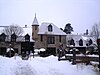 | |||
| Domaine Louis-Philippe-Hébert | 463, Rue de l'Ile-Belair Ouest, Rosemère, QC | 45°37′10″N73°47′51″W / 45.6194°N 73.7975°W | 11138 | | |||
| Maison Twin Chimney | , Rosemère, QC | 45°38′32″N73°47′05″W / 45.6421°N 73.7848°W | 13482 | 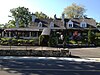 | |||
| Maison Hubert-Maisonneuve | 369, Chemin de la Grande-Cote, Rosemère, QC | 45°38′16″N73°47′25″W / 45.6379°N 73.7902°W | 13633 |  | |||
| Ancien séminaire de Sainte-Thérèse | Rue Saint-Louis, Sainte-Thérèse , QC | 45°38′30″N73°50′35″W / 45.6416°N 73.8431°W | 7152 | 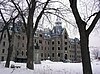 More images | |||
| Église Sainte-Thérèse-de-Blainville | Rue de l'Eglise, Sainte-Thérèse, QC | 45°38′25″N73°50′39″W / 45.6403°N 73.8441°W | 10323 | 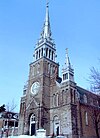 More images | |||
| Presbytère de Sainte-Thérèse-de-Blainville | 10, Rue de l'Eglise, Sainte-Thérèse, QC | 45°38′27″N73°50′39″W / 45.6407°N 73.8441°W | 10324 | | |||
| Maison Abraham-Dubois | 331, Boulevard de la Grande-Allee, Boisbriand , QC | 45°36′33″N73°49′56″W / 45.6092°N 73.8322°W | 9638 | 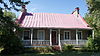 More images | |||
| Maison Léon-Dion | 394, Chemin de la Grande-Cote, Boisbriand, QC | 45°36′23″N73°50′02″W / 45.6063°N 73.8339°W | 11172 |  | |||
| Maison Jean-Joseph-Girouard | 3905, Rue Saint-Jean-Baptiste, Mirabel , QC | 45°34′08″N74°05′52″W / 45.5689°N 74.0979°W | 5126 | 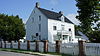 More images | |||
| Domaine et manoir de Belle-Rivière | 8106, Rue Belle-Riviere, Mirabel, QC | 45°37′35″N74°05′31″W / 45.6264°N 74.0919°W | 5286 |  More images | |||
| Moulin Légaré | 232, Rue Saint-Eustache, Saint-Eustache , QC | 45°33′29″N73°53′46″W / 45.5581°N 73.8962°W | 12429 | 4455 | 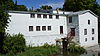 More images | ||
| Maison Chénier-Sauvé | 83 Rue Chenier, Saint-Eustache , QC | 45°33′20″N73°53′23″W / 45.5556°N 73.8896°W | 10943 | 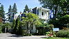 | |||
| Domaine Globensky | 235, Rue Saint-Eustache, Saint-Eustache, QC | 45°33′31″N73°53′45″W / 45.5586°N 73.8958°W | 4937 |  More images | |||
| Église de Saint-Eustache | 123, Rue Saint-Louis, Saint-Eustache, QC | 45°33′24″N73°53′18″W / 45.5568°N 73.8884°W | 7681 |  More images | |||
| Maison Lavigne-Richer | 275, Rue Saint-Eustache, Saint-Eustache, QC | 45°33′30″N73°53′51″W / 45.5583°N 73.8974°W | 10942 |  | |||
| Mairie de Saint-Eustache | 145, Rue Saint-Louis, Saint-Eustache, QC | 45°33′27″N73°53′20″W / 45.5576°N 73.8889°W | 10944 |  More images | |||
| Ancienne église presbytérienne de Saint-Eustache | Rue Saint-Eustache, Saint-Eustache, QC | 45°33′30″N73°53′50″W / 45.5583°N 73.8972°W | 10945 |  | |||
| Site du patrimoine de la Maison-Dumoulin | 2501, Chemin d'Oka, Deux-Montagnes , QC | 45°32′00″N73°54′22″W / 45.5334°N 73.9061°W | 11198 | 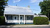 | |||
| Site du patrimoine de l'hôtel de ville | 803, Chemin d'Oka, Deux-Montagnes, QC | 45°32′30″N73°53′34″W / 45.5418°N 73.8929°W | 11201 |  | |||
| Site du patrimoine de la Petite-École-Jaune | 1304, Chemin d'Oka, Deux-Montagnes, QC | 45°32′17″N73°53′47″W / 45.538°N 73.8963°W | 11294 | 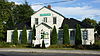 | |||
| Petite école jaune | 1304, Chemin d'Oka, Deux-Montagnes, QC | 45°32′17″N73°53′47″W / 45.538°N 73.8963°W | 11295 | | |||
| Site du patrimoine de la Maison-Bélair | 201, Chemin d'Oka, Deux-Montagnes, QC | 45°32′46″N73°53′28″W / 45.5462°N 73.8911°W | 11428 |  | |||
| Site du patrimoine de la Maison-Baudouin | 91, 24e Avenue, Deux-Montagnes, QC | 45°31′53″N73°54′06″W / 45.5313°N 73.9018°W | 13249 |  | |||
| Site du patrimoine de la Maison-Berthelet | 1506, Chemin d'Oka, Deux-Montagnes, QC | 45°32′13″N73°53′54″W / 45.5369°N 73.8982°W | 13250 |  | |||
| Canadian Pacific Railway Station | Main Street, L'Annonciation, QC | 46°24′53″N74°52′15″W / 46.4148°N 74.870921°W | 6546 |  | |||
| Canadian Pacific Railway Station | 700 Vaudreuil Road, Mont-Laurier, QC | 46°33′25″N75°29′27″W / 46.5570°N 75.4909°W | 6545 | | |||
| Église Christ Church | Route du Long-Sault, Saint-Andre-d'Argenteuil, QC | 45°33′40″N74°20′23″W / 45.5612°N 74.3398°W | 10528 | 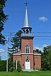 | |||
| Ancien bureau de poste | 83 Rue Saint-Vincent, Sainte-Agathe-des-Monts, QC | 46°02′56″N74°17′18″W / 46.0489°N 74.2883°W | 8969 | | |||
| Canadian Pacific Railway Station | 24 Rue St. Paul Est, Sainte-Agathe-des-Monts, QC | 46°03′06″N74°16′57″W / 46.0518°N 74.2825°W | 7098 | |