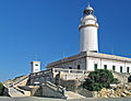
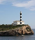
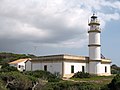
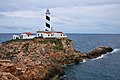
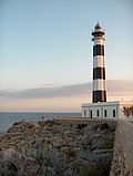
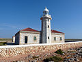
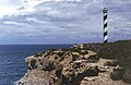
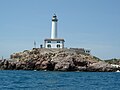
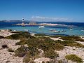
List of lighthouses in the Balearic Islands

Last updated

This is a list of lighthouses in the Balearic Islands. The Spanish archipelago lies at the western end of the Mediterranean Sea. [1] [2] [3]

Contents

Map all coordinates using: OpenStreetMap  
Download coordinates as: KML

Lighthouses

LighthouseImageLocation
Coordinates
IslandBuiltTower HeightFocal HeightRange
Formentor Cap Formentor Lighthouse2.jpg Cap de Formentor
39°57′41″N3°12′46″E / 39.96145°N 3.21271°E / 39.96145; 3.21271 (Formentor)
Majorca 186321 m (69 ft)210 m (689 ft)24 nmi (44 km)
Punta de l'Avançada Far de la Punta de l'Avancada.jpg Port de Pollença
39°53′59″N3°06′38″E / 39.89985°N 3.11064°E / 39.89985; 3.11064 (Punta de l'Avançada)
Majorca 190518 m (59 ft)29 m (95 ft)15 nmi (28 km)
Alcanada Lighthouse Alcanada3.jpg Alcúdia
39°50′07″N3°10′16″E / 39.83541°N 3.17117°E / 39.83541; 3.17117 (Alcanada)
Majorca 186115 m (49 ft)22 m (72 ft)11 nmi (20 km)
Capdepera Mallorca - Leuchtturm Capdepera3.jpg Capdepera
39°42′56″N3°28′39″E / 39.71558°N 3.47752°E / 39.71558; 3.47752 (Capdepera)
Majorca 186118 m (59 ft)76 m (249 ft)20 nmi (37 km)
Porto Colom Punta de ses Crestes.JPG Felanitx
39°24′50″N3°16′14″E / 39.41402°N 3.27065°E / 39.41402; 3.27065 (Porto Colom)
Majorca 186125 m (82 ft)42 m (138 ft)20 nmi (37 km)
Torre den Beu Auf dem Berg von ala Figuera.jpg Cala Figuera
39°19′47″N3°10′37″E / 39.32966°N 3.17699°E / 39.32966; 3.17699 (Torre den Beu)
Majorca Unknown6 m (20 ft)32 m (105 ft)10 nmi (19 km)
Cap Salines Far des Cap Salines 02.jpg Santanyí
39°15′55″N3°03′12″E / 39.26521°N 3.05341°E / 39.26521; 3.05341 (Cap de ses Salines)
Majorca 186317 m (56 ft)17 m (56 ft)11 nmi (20 km)
Cap Blanc Far Cap Blanc 2.jpg Llucmajor
39°21′49″N2°47′16″E / 39.36351°N 2.78780°E / 39.36351; 2.78780 (Cap Blanc)
Majorca 186312 m (39 ft)95 m (312 ft)15 nmi (28 km)
Porto Pí Torre de Senyals de Porto Pi.JPG Palma
39°32′55″N2°37′25″E / 39.54858°N 2.62362°E / 39.54858; 2.62362 (Portopí)
Majorca 161738 m (125 ft)41 m (135 ft)18 nmi (33 km)
Cala Figuera Far de Cala Figuera.jpg Son Ferrer
39°27′27″N2°31′21″E / 39.45749°N 2.52237°E / 39.45749; 2.52237 (Cala Figuera)
Majorca 186024 m (79 ft)45 m (148 ft)22 nmi (41 km)
Sa Mola Andratx, Faro de la Mola.jpg Andratx
39°31′54″N2°21′51″E / 39.53175°N 2.36425°E / 39.53175; 2.36425 (sa Mola)
Majorca 199310 m (33 ft)128 m (420 ft)12 nmi (22 km)
Cap Gros Far Cap Gros.JPG Port de Sóller
39°47′50″N2°40′54″E / 39.7971°N 2.68161°E / 39.7971; 2.68161 (Cap Gros)
Majorca 185922 m (72 ft)120 m (394 ft)19 nmi (35 km)
La Creu Sa Creu Lighthouse R01.jpg Port de Sóller
39°47′49″N2°41′22″E / 39.79695°N 2.68940°E / 39.79695; 2.68940 (la Creu)
Majorca 1864/194513 m (43 ft)35 m (115 ft)10 nmi (19 km)
Llebeig Sa Dragonera, Cap de Llebeig 1.jpeg Dragonera
39°34′27″N2°18′17″E / 39.57417°N 2.30460°E / 39.57417; 2.30460 (Llebeig)
Dragonera 191015 m (49 ft)130 m (427 ft)21 nmi (39 km)
Na Pòpia Far de Na Popis.JPG Dragonera
39°35′11″N2°19′02″E / 39.58636°N 2.31713°E / 39.58636; 2.31713 (Na Pòpia)
Dragonera 185212 m (39 ft)363 m (1,191 ft)Inactive
Tramuntana Far de Tramuntana.jpg Dragonera
39°35′53″N2°20′17″E / 39.59803°N 2.33818°E / 39.59803; 2.33818 (Tramuntana)
Dragonera 191015 m (49 ft)67 m (220 ft)14 nmi (26 km)
Cavalleria Faro de Cavalleria.JPG Sanisera
40°05′21″N4°05′32″E / 40.08909°N 4.09227°E / 40.08909; 4.09227 (Cavallería)
Menorca 185715 m (49 ft)94 m (308 ft)26 nmi (48 km)
Favàritx E09 Far de Favaritx.JPG Mahón
39°59′50″N4°16′01″E / 39.99724°N 4.26684°E / 39.99724; 4.26684 (Favàritx)
Menorca 192228 m (92 ft)47 m (154 ft)21 nmi (39 km)
Illa de l'Aire Faro de la Isla del Aire.jpg Illa de l'Aire
39°47′58″N4°17′35″E / 39.79945°N 4.293180°E / 39.79945; 4.293180 (l’Illa de l’Aire)
Menorca 186038 m (125 ft)53 m (174 ft)18 nmi (33 km)
Cap d'Artrutx Faro de Artrutx.jpg Cala en Bosch
39°55′21″N3°49′27″E / 39.92258°N 3.82424°E / 39.92258; 3.82424 (Far d'Artrutx)
Menorca 185934 m (112 ft)45 m (148 ft)19 nmi (35 km)
Ciutadella Sa Farola.jpg Ciutadella
39°59′46″N3°49′22″E / 39.99621°N 3.82276°E / 39.99621; 3.82276 (Ciutadella)
Menorca 186313 m (43 ft)21 m (69 ft)14 nmi (26 km)
Punta Nati Faro Punta Nati JGT.jpg Ciutadella
40°03′01″N3°49′25″E / 40.05021°N 3.82363°E / 40.05021; 3.82363 (Punta Nati)
Menorca 191319 m (62 ft)42 m (138 ft)18 nmi (33 km)
Punta Moscarter Lighthouse portinatx eivissa 2003 05.jpg Portinatx
39°07′03″N1°31′59″E / 39.11762°N 1.53317°E / 39.11762; 1.53317 (Moscater)
Ibiza 197852 m (171 ft)93 m (305 ft)18 nmi (33 km)
Tagomago Tagomago.jpg Tagomago
39°01′57″N1°38′57″E / 39.03257°N 1.64909°E / 39.03257; 1.64909 (Tagomago)
Ibiza 191423 m (75 ft)86 m (282 ft)21 nmi (39 km)
Botafoc Eivissa - Illa Grossako itsasargia.jpg Ibiza (town)
38°54′15″N1°27′14″E / 38.90416°N 1.45388°E / 38.90416; 1.45388 (Botafoc)
Ibiza 186116 m (52 ft)31 m (102 ft)14 nmi (26 km)
Illa des Penjats FarEivissa.jpg Sant Francesc de s'Estany
38°48′52″N1°24′42″E / 38.81451°N 1.41178°E / 38.81451; 1.41178 (Penjats)
Ibiza 186117 m (56 ft)27 m (89 ft)10 nmi (19 km)
Bleda Plana Sant Josep de sa Talaia
38°58′47″N1°09′32″E / 38.97984°N 1.15902°E / 38.97984; 1.15902 (na Bleda Plana)
Ibiza 19728 m (26 ft)28 m (92 ft)10 nmi (19 km)
Conillera Aerial view of the island of Sa Conillera, near St. Antoni de Portmany.jpg Illa Conillera
38°59′37″N1°12′45″E / 38.99361°N 1.21262°E / 38.99361; 1.21262 (sa Conillera)
Ibiza 185718 m (59 ft)85 m (279 ft)18 nmi (33 km)
En Pou Illa des Porcs.JPG S'Espalmador
38°47′56″N1°25′18″E / 38.79902°N 1.42162°E / 38.79902; 1.42162 (en Pou)
Formentera 186425 m (82 ft)28 m (92 ft)10 nmi (19 km)
La Mola Formentera 5 (2125831467).jpg Formentera
38°39′48″N1°35′03″E / 38.66337°N 1.58430°E / 38.66337; 1.58430 (La Mola)
Formentera 186122 m (72 ft)142 m (466 ft)23 nmi (43 km)
Cap de Barbaría Far d'es cap de Barbaria 01.JPG Formentera
38°38′28″N1°23′22″E / 38.6411°N 1.38951°E / 38.6411; 1.38951 (Cap de Barbaría)
Formentera 197219 m (62 ft)78 m (256 ft)20 nmi (37 km)
Na Foradada Far de na foradada(cabrera).jpg Cabrera
39°12′26″N2°58′43″E / 39.20711°N 2.97862°E / 39.20711; 2.97862 (na Foradada)
Cabrera 192613 m (43 ft)42 m (138 ft)10 nmi (19 km)
N'Ensiola Far de n' Enciola.JPG Cabrera
39°07′45″N2°55′17″E / 39.12919°N 2.92145°E / 39.12919; 2.92145 (n'Ensiola)
Cabrera 187021 m (69 ft)121 m (397 ft)20 nmi (37 km)

See also

Related Research Articles

Pharology is the scientific study of lighthouses and signal lights, their construction and illumination. The variation pharonology is occasionally attested. Those who study or are enthused by lighthouses are known as pharologists.

Cap dArtrutx Lighthouse Lighthouse on Menorca, Spain

The Cap d'Artrutx Lighthouse or Artrutx Lighthouse is an active 19th century lighthouse located on the low-lying headland of the same name on the Spanish island of Menorca. It was completed in 1859 but the tower was significantly increased in height in 1969. Automated in 1980, the keeper's accommodation is now used as a restaurant.

Illa de lAire Lighthouse Lighthouse on Menorca, Spain

The Illa de l’Aire Lighthouse is an active lighthouse on the islet of Illa de l'Aire, on the southeast coast of the Spanish island of Menorca.

Ciutadella Lighthouse Lighthouse on Menorca, Spain

The Ciutadella, Punta de Sa Farola or Sa Farola Lighthouse is an active 19th century lighthouse on the Spanish island of Menorca. Originally completed in 1863, the tower has subsequently undergone a number of modifications. It lies close to the seaward entrance of the port of Ciutadella on the Sa Farola point, at the western end of the island. On the opposite headland is the Castell de Sant Nicolau, a 17th-century defensive tower.

Favàritx Lighthouse Lighthouse on Menorca, Spain

The Favàritx Lighthouse is an active lighthouse on the Spanish island of Menorca.

Formentor Lighthouse Lighthouse on Mallorca, Spain

The Formentor or Cap de Formentor Lighthouse is an active lighthouse on the Spanish island of Majorca.

Punta de Anaga Lighthouse Lighthouse on Tenerife, Spain

The Punta de Anaga Lighthouse is an active lighthouse on the Canary island of Tenerife, in the municipality of Santa Cruz de Tenerife. Punta de Anaga is the most northerly point on the island, and is where the Anaga mountain range meets the sea.

Punta del Castillete Lighthouse Lighthouse on Gran Canaria, Spain

The Punta del Castillete Lighthouse is an active lighthouse on the Canary island of Gran Canaria. It is located on cliffs above the resort and fishing harbour of Puerto de Mogán, in the municipality of Mogán. Punta Castillete is on the south-western side of the island facing the Atlantic Ocean, and lies between Maspalomas Lighthouse to the south and the lighthouse of Punta Sardina to the north.

Punta Orchilla Lighthouse Lighthouse on El Hierro, Spain

The Punta Orchilla Lighthouse is an active lighthouse on the Canary island of El Hierro in the municipality of El Pinar. The need for a lighthouse on the island was highlighted in the second maritime lighting plan for the Canaries, and it first became operational in 1933.

Arenas Blancas Lighthouse Lighthouse on La Palma, Spain

The Arenas Blancas Lighthouse is an active lighthouse on the Canary island of La Palma in the municipality of Villa de Mazo, near the village of La Salemera. The larger settlement of Mazo lies 8 km (5.0 mi) to the north-west.

Punta Sardina Lighthouse Lighthouse on Gran Canaria, Spain

The Punta Sardina Lighthouse is an active lighthouse on the Canary island of Gran Canaria. It is located north of the small town of Sardina, in the municipality of Gáldar. The Punta Sardina light marks the north-western extremity of the island, and lies between the Punta del Castillete lighthouse near Puerto de Mogán to the south and the La Isleta lighthouse of Las Palmas to the east.

Punta Abona Lighthouse Lighthouse on Tenerife, Spain

The Punta Abona Lighthouse is an active lighthouse on the south-eastern coast of Tenerife in the Canary islands. It is located between Abades and Poris de Abona, in the municipality of Arico. The lighthouse was the second to be constructed on the rocky headland of Punta Abona, which marks the south-east side of the island, and lies between the Punta de Anaga Lighthouse to the north and the Punta Rasca Lighthouse of Arona to the south.

Puerto del Rosario Lighthouse Lighthouse on Fuerteventura, Spain

The Puerto del Rosario Lighthouse also known as the Punta Gaviota Lighthouse is a modern active lighthouse on the Canary island of Fuerteventura. It is located in an industrial area at the north-eastern end of the town of Puerto del Rosario, the capital and major port of the island in the Province of Las Palmas.

Punta Rasca Lighthouse Lighthouse in Tenerife, Spain

The Punta Rasca Lighthouse is an active lighthouse in the municipality of Arona on the Canary Island of Tenerife. The current lighthouse was the second to be constructed on the headland of Punta Rasca, which is located close to the most southerly point on the island at Punta Salemas. It lies between the Punta Abona Lighthouse to the northeast and the Punta de Teno Lighthouse of Buenavista del Norte to the northwest.

Punta de Teno Lighthouse Lighthouse on Tenerife, Spain

The Punta de Teno Lighthouse is an active lighthouse in the municipality of Buenavista del Norte on the Canary Island of Tenerife. The current lighthouse was the second to be constructed on the narrow rocky headland of Punta de Teno, which is the most westerly point on the island. It is one of seven lighthouses which mark the coastline of Tenerife, and lies between the Punta Rasca Lighthouse to the southeast, and the modern lighthouse of Buenavista to the northeast.

Puerto de la Cruz Lighthouse Lighthouse on Tenerife, Spain

The Puerto de la Cruz Lighthouse is an active lighthouse in Puerto de la Cruz on the northern coast of Tenerife in the Canary Islands. This modern lighthouse is situated within a seafront car park, to the west of the small port in the town. It is one of seven lighthouses which mark the coastline of Tenerife, and lies between two other modern lighthouses of Punta del Hidalgo to the northeast, and Buenavista to the west.

Punta del Hidalgo Lighthouse Lighthouse on Tenerife, Spain

The Punta del Hidalgo Lighthouse is an active lighthouse in Punta del Hidalgo within the municipality of San Cristóbal de La Laguna on the northeast coast of Tenerife in the Canary Islands.

Punta de Melenara Lighthouse Lighthouse on Gran Canaria, Spain

The Punta de Melenara Lighthouse also known as the Faro de Taliarte is an active 20th century lighthouse on the Spanish island of Gran Canaria in the Canary islands.

Punta Delgada Lighthouse Lighthouse on Alegranza, Spain

Punta Delgada or Alegranza Lighthouse is an active 19th century lighthouse on the Spanish island of Alegranza in the Canary islands. Alegranza lies to the north of the larger island of Lanzarote, it is part of the Chinijo Archipelago within the Teguise municipality.

References

  1. Rowlett, Russ. "Lighthouses of Spain: Balearic Islands". The Lighthouse Directory. University of North Carolina at Chapel Hill . Retrieved 1 September 2015.
  2. List of Lights, Pub. 113: The West Coasts of Europe and Africa, the Mediterranean Sea, Black Sea and Azovskoye More (Sea of Azov) (PDF). List of Lights . United States National Geospatial-Intelligence Agency. 2015. p. 84.
  3. "Lighthouses". Balearic Lighthouses. Port Authority of the Balearic Islands. Retrieved 2 September 2015.