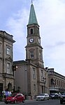
Name Location Date Listed Grid Ref. [note 1] Geo-coordinates Notes LB Number [note 2] Image Bank Street, The Townhouse 55°52′00″N 3°58′50″W / 55.866602°N 3.980648°W / 55.866602; -3.980648 (Bank Street, The Townhouse ) Category B 20926 Upload another image
Towers Road, Wester Moffat Hospital, Wester Moffat House 55°52′07″N 3°56′27″W / 55.868736°N 3.940944°W / 55.868736; -3.940944 (Towers Road, Wester Moffat Hospital, Wester Moffat House ) Category B 20930 2-10 (Even Nos) Bank Street, New Cross Corner 55°51′59″N 3°58′50″W / 55.866404°N 3.980686°W / 55.866404; -3.980686 (2-10 (Even Nos) Bank Street, New Cross Corner ) Category B 20936 1 Kippen Street, Rochsolloch Primary School Including Boundary Wall And Railings 55°51′43″N 3°59′49″W / 55.862009°N 3.996826°W / 55.862009; -3.996826 (1 Kippen Street, Rochsolloch Primary School Including Boundary Wall And Railings ) Category C(S) 20943 Upload another image See more images
14 Anderson Street 55°52′01″N 3°58′56″W / 55.866973°N 3.98217°W / 55.866973; -3.98217 (14 Anderson Street ) Category C(S) 48540 16-20 (Even Nos) And 24-28 (Even Nos) Anderson Street 55°52′01″N 3°58′58″W / 55.866872°N 3.982852°W / 55.866872; -3.982852 (16-20 (Even Nos) And 24-28 (Even Nos) Anderson Street ) Category B 48541 East High Street, Fruitfield House 55°52′09″N 3°58′51″W / 55.869123°N 3.980937°W / 55.869123; -3.980937 (East High Street, Fruitfield House ) Category C(S) 48548 Grahamshill Street, Annfield 55°52′06″N 3°57′36″W / 55.86839°N 3.959914°W / 55.86839; -3.959914 (Grahamshill Street, Annfield ) Category C(S) 48552 North Biggar Road, Stanley Old College Gate Fragment 55°52′07″N 3°58′06″W / 55.868676°N 3.968447°W / 55.868676; -3.968447 (North Biggar Road, Stanley Old College Gate Fragment ) Category B 48556 4 And 6 Victoria Place, (Swiss Villa And Clydesdale) Including Gates And Railings 55°51′48″N 3°58′58″W / 55.863404°N 3.982819°W / 55.863404; -3.982819 (4 And 6 Victoria Place, (Swiss Villa And Clydesdale) Including Gates And Railings ) Category B 48560 Wellwynd, Former West Parish Church 55°51′59″N 3°59′03″W / 55.86652°N 3.984064°W / 55.86652; -3.984064 (Wellwynd, Former West Parish Church ) Category B 20921 Upload another image
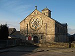
Wellwynd, Wellwynd Church, Church Of Scotland 55°52′03″N 3°58′59″W / 55.867534°N 3.983061°W / 55.867534; -3.983061 (Wellwynd, Wellwynd Church, Church Of Scotland ) Category C(S) 20923 5-11 (Odd Nos), 4 And 6 Dornoch Way, Former Cairnhill Stables 55°51′16″N 3°59′16″W / 55.854544°N 3.98772°W / 55.854544; -3.98772 (5-11 (Odd Nos), 4 And 6 Dornoch Way, Former Cairnhill Stables ) Category B 20927 24 Victoria Place, The Red House Including Boundary Wall And Gatepiers 55°51′46″N 3°59′12″W / 55.862848°N 3.986594°W / 55.862848; -3.986594 (24 Victoria Place, The Red House Including Boundary Wall And Gatepiers ) Category B 20951 54 Victoria Place, The Anchorage Including Boundary Wall And Gatepiers 55°51′44″N 3°59′25″W / 55.862323°N 3.990195°W / 55.862323; -3.990195 (54 Victoria Place, The Anchorage Including Boundary Wall And Gatepiers ) Category B 48563 23 And 25 Wellwynd 55°52′03″N 3°59′01″W / 55.867424°N 3.983727°W / 55.867424; -3.983727 (23 And 25 Wellwynd ) Category C(S) 20929 Springwells Avenue, St Paul's Episcopal Church Including Church Hall And Boundary Wall 55°52′07″N 3°57′56″W / 55.868522°N 3.965691°W / 55.868522; -3.965691 (Springwells Avenue, St Paul's Episcopal Church Including Church Hall And Boundary Wall ) Category C(S) 20931 Upload another image
Johnston Street, Flowerhill Parish Church, Church Of Scotland, Including Church Hall And Manse 55°52′01″N 3°58′34″W / 55.866935°N 3.976158°W / 55.866935; -3.976158 (Johnston Street, Flowerhill Parish Church, Church Of Scotland, Including Church Hall And Manse ) Category B 20932 Upload another image
Broomknoll Street, Monklands District Council Housing Department 55°51′53″N 3°58′48″W / 55.864608°N 3.98002°W / 55.864608; -3.98002 (Broomknoll Street, Monklands District Council Housing Department ) Category C(S) 20938 5 Graham Street Including Flanking Walls 55°51′59″N 3°58′48″W / 55.866273°N 3.979897°W / 55.866273; -3.979897 (5 Graham Street Including Flanking Walls ) Category B 20940 56 Stirling Street, Airdrie Savings Bank Including Gatepiers And Gates 55°51′58″N 3°58′59″W / 55.866061°N 3.983002°W / 55.866061; -3.983002 (56 Stirling Street, Airdrie Savings Bank Including Gatepiers And Gates ) Category B 20949 6, 8 And 8A East High Street 55°52′07″N 3°58′55″W / 55.86861°N 3.982077°W / 55.86861; -3.982077 (6, 8 And 8A East High Street ) Category C(S) 48550 Graham Street, Airdrie Baptist Church Including Boundary Wall And Gatepiers 55°52′00″N 3°58′33″W / 55.866634°N 3.97584°W / 55.866634; -3.97584 (Graham Street, Airdrie Baptist Church Including Boundary Wall And Gatepiers ) Category C(S) 48551 North Biggar Road, 2 And 3 Stanley Park Including Boundary Wall And Gatepiers 55°52′07″N 3°58′08″W / 55.868606°N 3.968923°W / 55.868606; -3.968923 (North Biggar Road, 2 And 3 Stanley Park Including Boundary Wall And Gatepiers ) Category C(S) 48555 Upload another image
10 Stirling Street 55°51′58″N 3°58′53″W / 55.86622°N 3.981476°W / 55.86622; -3.981476 (10 Stirling Street ) Category B 48559 16 And 18 North Bridge Street, Airdrie Children's Board 55°52′08″N 3°58′58″W / 55.869011°N 3.982833°W / 55.869011; -3.982833 (16 And 18 North Bridge Street, Airdrie Children's Board ) Category B 20944 Upload another image
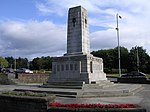
Broomknoll Street, Broomknoll Parish Church, Church Of Scotland 55°51′54″N 3°58′51″W / 55.865132°N 3.980957°W / 55.865132; -3.980957 (Broomknoll Street, Broomknoll Parish Church, Church Of Scotland ) Category C(S) 48544 2 East High Street 55°52′07″N 3°58′56″W / 55.868525°N 3.982345°W / 55.868525; -3.982345 (2 East High Street ) Category C(S) 48549 2-10 (Even Nos) Hallcraig Street, Airdrie Market Building 55°52′02″N 3°58′49″W / 55.867164°N 3.980326°W / 55.867164; -3.980326 (2-10 (Even Nos) Hallcraig Street, Airdrie Market Building ) Category C(S) 48553 Mulvey Crescent, Airdrie War Memorial 55°51′50″N 3°59′45″W / 55.863947°N 3.995887°W / 55.863947; -3.995887 (Mulvey Crescent, Airdrie War Memorial ) Category C(S) 48554 Upload another image
80-82 (Even Nos), 86 South Bridge Street And 4 Anderson Street 55°52′01″N 3°58′53″W / 55.866996°N 3.981276°W / 55.866996; -3.981276 (80-82 (Even Nos), 86 South Bridge Street And 4 Anderson Street ) Category C(S) 48558 Hallcraig Street, St Margaret's Roman Catholic Church Including Presbytery And Boundary Wall 55°52′04″N 3°58′32″W / 55.867681°N 3.975605°W / 55.867681; -3.975605 (Hallcraig Street, St Margaret's Roman Catholic Church Including Presbytery And Boundary Wall ) Category B 20924 Airdrie Road, Clarkston Parish Church, Church Of Scotland 55°52′22″N 3°56′44″W / 55.872778°N 3.945605°W / 55.872778; -3.945605 (Airdrie Road, Clarkston Parish Church, Church Of Scotland ) Category C(S) 20925 Stirling Street, Sir John Wilson Town Hall Including Gatepiers 55°51′56″N 3°59′01″W / 55.865475°N 3.98366°W / 55.865475; -3.98366 (Stirling Street, Sir John Wilson Town Hall Including Gatepiers ) Category B 20947 Upload another image
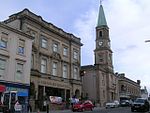
Wellwynd, Airdrie Public Library 55°51′59″N 3°58′59″W / 55.866382°N 3.983162°W / 55.866382; -3.983162 (Wellwynd, Airdrie Public Library ) Category C(S) 20950 31 Victoria Place, Flowerhill Manse Including Boundary Wall And Gatepiers 55°51′46″N 3°59′04″W / 55.862678°N 3.98438°W / 55.862678; -3.98438 (31 Victoria Place, Flowerhill Manse Including Boundary Wall And Gatepiers ) Category C(S) 48562 Bell Street, Methodist Church 55°52′00″N 3°59′06″W / 55.866666°N 3.985063°W / 55.866666; -3.985063 (Bell Street, Methodist Church ) Category B 20922 Arran Drive, Commonhead, Street, Arranview Including Gatepiers 55°52′23″N 3°59′16″W / 55.873156°N 3.987728°W / 55.873156; -3.987728 (Arran Drive, Commonhead, Street, Arranview Including Gatepiers ) Category B 20928 Motherwell Street, Rawyards House 55°52′28″N 3°57′47″W / 55.874406°N 3.963079°W / 55.874406; -3.963079 (Motherwell Street, Rawyards House ) Category C(S) 20933 Bank Street, Former Royal Bank Of Scotland 55°52′00″N 3°58′50″W / 55.866764°N 3.980641°W / 55.866764; -3.980641 (Bank Street, Former Royal Bank Of Scotland ) Category B 20937 Upload another image
77-83 (Odd Nos) High Street 55°52′04″N 3°59′07″W / 55.86765°N 3.985305°W / 55.86765; -3.985305 (77-83 (Odd Nos) High Street ) Category C(S) 20942 Coatdyke, Centenary Avenue, Railway Viaduct 55°51′49″N 4°00′09″W / 55.863733°N 4.002444°W / 55.863733; -4.002444 (Coatdyke, Centenary Avenue, Railway Viaduct ) Category B 49409 93, 95 High Street, Charlie's Bar 55°52′03″N 3°59′08″W / 55.867555°N 3.985652°W / 55.867555; -3.985652 (93, 95 High Street, Charlie's Bar ) Category C(S) 20934 35 Quarry Road Including Boundary Wall 55°52′20″N 3°58′54″W / 55.872112°N 3.981696°W / 55.872112; -3.981696 (35 Quarry Road Including Boundary Wall ) Category C(S) 20946 12-20 (Even Nos) Bank Street 55°52′01″N 3°58′51″W / 55.866889°N 3.980711°W / 55.866889; -3.980711 (12-20 (Even Nos) Bank Street ) Category C(S) 48543 40 South Bridge Street 55°52′04″N 3°58′56″W / 55.86771°N 3.982143°W / 55.86771; -3.982143 (40 South Bridge Street ) Category C(S) 48557 Anderson Street, Airdrie Arts Centre 55°52′00″N 3°58′54″W / 55.866781°N 3.981792°W / 55.866781; -3.981792 (Anderson Street, Airdrie Arts Centre ) Category B 20935 Chapel Street, Educational Resource Centre, Formerly Chapelside Primary School, Including Boundary Walls, Gatepiers, Gates And Railings 55°52′17″N 3°58′35″W / 55.871451°N 3.97642°W / 55.871451; -3.97642 (Chapel Street, Educational Resource Centre, Formerly Chapelside Primary School, Including Boundary Walls, Gatepiers, Gates And Railings ) Category B 20939 7 Graham Street 55°51′59″N 3°58′47″W / 55.866284°N 3.979721°W / 55.866284; -3.979721 (7 Graham Street ) Category C(S) 20941 11-13 (Odd Nos) Stirling Street 55°51′57″N 3°58′53″W / 55.865872°N 3.981315°W / 55.865872; -3.981315 (11-13 (Odd Nos) Stirling Street ) Category B 20948 Broomknoll Street, Ebenezer Congregational Chapel 55°51′56″N 3°58′49″W / 55.865466°N 3.980303°W / 55.865466; -3.980303 (Broomknoll Street, Ebenezer Congregational Chapel ) Category C(S) 48545 8-16 (Even Nos) Broomknoll Street 55°51′55″N 3°58′51″W / 55.865402°N 3.980923°W / 55.865402; -3.980923 (8-16 (Even Nos) Broomknoll Street ) Category C(S) 48546 18 And 20 Broomknoll Street 55°51′55″N 3°58′51″W / 55.865276°N 3.980933°W / 55.865276; -3.980933 (18 And 20 Broomknoll Street ) Category C(S) 48547 26 (Upper And Lower Flat) Victoria Place, Dalmagarry And Cairnbaan Including Boundary Wall And Gatepiers 55°51′46″N 3°59′13″W / 55.862796°N 3.987055°W / 55.862796; -3.987055 (26 (Upper And Lower Flat) Victoria Place, Dalmagarry And Cairnbaan Including Boundary Wall And Gatepiers ) Category C(S) 48561