List
| Name | Location | Date Listed | Grid Ref. [note 1] | Geo-coordinates | Notes | LB Number [note 2] | Image |
|---|---|---|---|---|---|---|---|
| Central Avenue, 5 Beech Avenue, Ashfield Including Boundary Walls And Gatepiers | 55°49′07″N4°10′31″W / 55.818717°N 4.175401°W | Category B | 33792 |  Upload Photo | |||
| Flemington Farm (Off Flemington Road) | 55°48′06″N4°07′39″W / 55.801786°N 4.127594°W | Category B | 33665 |  | |||
| Cambuslang, 13 Tabernacle Lane, Masonic Hall | 55°49′06″N4°09′56″W / 55.818317°N 4.16553°W | Category C(S) | 49643 | 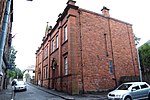 | |||
| 2 Glasgow Road, Beech Avenue, Trinity Parish Church And Halls, Boundary Walls, Gates And Gatepiers | 55°49′11″N4°10′30″W / 55.819678°N 4.174928°W | Category B | 33794 | 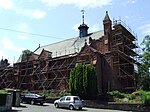 | |||
| 6, 6A, 8 Milton Avenue, Wellshot House | 55°49′04″N4°10′50″W / 55.817798°N 4.180649°W | Category B | 33796 | Upload Photo | |||
| Greenlees Road And 2 Tabernacle Street, Former Cambuslang Public School | 55°49′04″N4°10′01″W / 55.817763°N 4.16684°W | Category B | 33666 |  | |||
| Cairns Road, Cambuslang Old Parish Church Including Churchyard, Boundary Walls, Gates And Gatepiers | 55°48′50″N4°09′47″W / 55.813858°N 4.163°W | Category B | 33659 |  | |||
| 63, 65 West Coats Road, Including Boundary Walls And Gatepiers | 55°48′58″N4°10′32″W / 55.816233°N 4.17563°W | Category B | 33797 | Upload Photo | |||
| Gilbertfield Castle | 55°48′11″N4°09′02″W / 55.802967°N 4.150651°W | Category B | 1060 |  | |||
| Burnside Road, Church Avenue, Burnside Parish Church Including Halls, Session House, Boundary Walls And Railings | 55°48′51″N4°11′59″W / 55.814042°N 4.199768°W | Category B | 33788 | 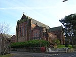 | |||
| Waterside | 55°46′46″N4°14′18″W / 55.779363°N 4.238399°W | Category C(S) | 6630 | Upload Photo | |||
| 60, Brownside Road, West Coats Primary School Including Boundary Walls, Gatepiers, Gates And Railings | 55°48′56″N4°10′32″W / 55.815508°N 4.175462°W | Category B | 33787 | 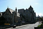 | |||
| 2A Cadzow Drive, Greenlees Road, Cambuslang Baptist Church Including Boundary Walls, Gates And Railings | 55°48′58″N4°10′02″W / 55.816076°N 4.167209°W | Category C(S) | 33790 |  | |||
| 25 Central Avenue, Hotel | 55°49′09″N4°10′44″W / 55.819277°N 4.178849°W | Category B | 33791 | Upload Photo | |||
| 4 Central Avenue, 21 Wellshot Drive | 55°49′05″N4°10′28″W / 55.818151°N 4.174428°W | Category B | 33793 | Upload Photo | |||
| Main Street, Savoy Bingo Club (Former Savoy Cinema) | 55°49′07″N4°09′58″W / 55.818514°N 4.166067°W | Category C(S) | 51158 | 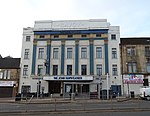 | |||
| 4 Busheyhill Street, Former School | 55°49′03″N4°10′03″W / 55.817572°N 4.167516°W | Category B | 33789 |  | |||
| 37 Greenlees Road, Cambuslang Institute Including Boundary Walls | 55°49′00″N4°10′03″W / 55.816591°N 4.167573°W | Category B | 33795 | 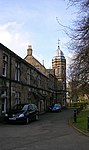 | |||
| Clydeford Road, Dovecot At Cambuslang Golf Course | 55°49′19″N4°09′44″W / 55.821879°N 4.162279°W | Category B | 33664 |  | |||
| 7, 7A Cairns Road, Cambuslang Old Parish Church Hall | 55°48′49″N4°09′44″W / 55.813493°N 4.162341°W | Category C(S) | 33660 |  |