Name Location Date Listed Grid Ref. [note 1] Geo-coordinates Notes LB Number [note 2] Image 1-5 (Inclusive Nos) Blairbeth Terrace And 76 Blairbeth Road 55°48′56″N 4°12′12″W / 55.815427°N 4.203214°W / 55.815427; -4.203214 (1-5 (Inclusive Nos) Blairbeth Terrace And 76 Blairbeth Road ) Category B 33703 Upload another image
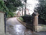
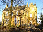
14 Burnside Road, The Ingle, Including Gateway, Quadrants, Piers, Gates, Railings, Coach House/Stable Block And Summer House 55°48′44″N 4°12′01″W / 55.812119°N 4.200218°W / 55.812119; -4.200218 (14 Burnside Road, The Ingle, Including Gateway, Quadrants, Piers, Gates, Railings, Coach House/Stable Block And Summer House ) Category B 33704 Upload another image
152, 154 Main Street, Rutherglen, Kirkwood Street, St Columbkille's RC Church [ de ] 55°49′39″N 4°12′50″W / 55.827594°N 4.213818°W / 55.827594; -4.213818 (152, 154 Main Street, Rutherglen, Kirkwood Street, St Columbkille's RC Church [ de] ) Category A 33567 Upload another image
King Street, Burgh Primary School With Boundary Walls, Railings And Gatepiers 55°49′45″N 4°13′02″W / 55.82926°N 4.217138°W / 55.82926; -4.217138 (King Street, Burgh Primary School With Boundary Walls, Railings And Gatepiers ) Category B 50135 Upload another image
141 -147 (Odd Nos) Main Street, Rutherglen 55°49′43″N 4°12′51″W / 55.828525°N 4.214062°W / 55.828525; -4.214062 (141 -147 (Odd Nos) Main Street, Rutherglen ) Category C(S) 33565 Upload another image
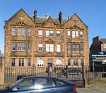
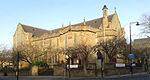
Melrose Avenue, Rutherglen, Stonelaw High School (Main Block) 55°49′31″N 4°12′34″W / 55.825266°N 4.209343°W / 55.825266; -4.209343 (Melrose Avenue, Rutherglen, Stonelaw High School (Main Block) ) Category B 33568 Upload another image
Mill Street, Overtoun Park , Bandstand 55°49′18″N 4°12′48″W / 55.821556°N 4.213235°W / 55.821556; -4.213235 (Mill Street, Overtoun Park, Bandstand ) Category B 33569 Upload another image
Mill Street, Overtoun Park , Gateway 55°49′22″N 4°12′58″W / 55.822684°N 4.216013°W / 55.822684; -4.216013 (Mill Street, Overtoun Park, Gateway ) Category B 33570 Upload another image
153 Stonelaw Road, Stonelaw Parish Church Including Gatepiers And Railings 55°49′25″N 4°12′30″W / 55.823738°N 4.208362°W / 55.823738; -4.208362 (153 Stonelaw Road, Stonelaw Parish Church Including Gatepiers And Railings ) Category B 33573 Upload another image
20-24 Queen Street And 115 King Street, Masonic Hall 55°49′44″N 4°12′58″W / 55.828929°N 4.216065°W / 55.828929; -4.216065 (20-24 Queen Street And 115 King Street, Masonic Hall ) Category C(S) 50134 Upload another image
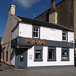
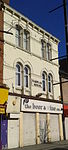
209 Main Street, Bower Bar 55°49′44″N 4°12′42″W / 55.828801°N 4.211715°W / 55.828801; -4.211715 (209 Main Street, Bower Bar ) Category C(S) 50136 Upload another image
73 Blairbeth Road, Duncraggan, Including Gatepiers And Boundary Walls 55°48′59″N 4°12′10″W / 55.816281°N 4.202688°W / 55.816281; -4.202688 (73 Blairbeth Road, Duncraggan, Including Gatepiers And Boundary Walls ) Category B 33702 18 Farmeloan Road, Rutherglen, Former Rutherglen East Church 55°49′44″N 4°12′36″W / 55.82883°N 4.21005°W / 55.82883; -4.21005 (18 Farmeloan Road, Rutherglen, Former Rutherglen East Church ) Category B 33554 Upload another image
Main Street Rutherglen, Mercat Cross 55°49′43″N 4°12′48″W / 55.828477°N 4.213439°W / 55.828477; -4.213439 (Main Street Rutherglen, Mercat Cross ) Category C(S) 33558 Upload another image
131, 139 Main Street, Rutherglen, District Council Offices (Originally Town Hall) 55°49′43″N 4°12′53″W / 55.828568°N 4.214624°W / 55.828568; -4.214624 (131, 139 Main Street, Rutherglen, District Council Offices (Originally Town Hall) ) Category A 33564 Upload another image
Mill Street, Overtoun Park , Queen Victoria Jubilee Fountain 55°49′19″N 4°12′48″W / 55.821967°N 4.213402°W / 55.821967; -4.213402 (Mill Street, Overtoun Park, Queen Victoria Jubilee Fountain ) Category B 33571 Upload another image
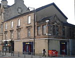
56,58 And 60 Main Street, Mecca Bingo (Former Vogue Cinema) 55°49′40″N 4°13′02″W / 55.827911°N 4.217189°W / 55.827911; -4.217189 (56,58 And 60 Main Street, Mecca Bingo (Former Vogue Cinema) ) Category C(S) 50139 Upload another image
3 Western Avenue, Rutherglen West Parish Church (Munro Church) Church Of Scotland 55°49′45″N 4°13′14″W / 55.829035°N 4.220638°W / 55.829035; -4.220638 (3 Western Avenue, Rutherglen West Parish Church (Munro Church) Church Of Scotland ) Category B 33700 Upload another image
Main Street Rutherglen, Old Parish Churchyard Including Kirk Port And Gateways 55°49′42″N 4°12′57″W / 55.828405°N 4.2157°W / 55.828405; -4.2157 (Main Street Rutherglen, Old Parish Churchyard Including Kirk Port And Gateways ) Category B 33561 Upload another image
34 Broomieknow Road, Blairtum Park House Including Gatepiers 55°49′01″N 4°12′39″W / 55.816989°N 4.210821°W / 55.816989; -4.210821 (34 Broomieknow Road, Blairtum Park House Including Gatepiers ) Category C(S) 33550 Upload another image
Main Street Rutherglen, Queen Street Rutherglen Old Parish Church 55°49′43″N 4°12′57″W / 55.828611°N 4.21576°W / 55.828611; -4.21576 (Main Street Rutherglen, Queen Street Rutherglen Old Parish Church ) Category B 33562 Upload another image
159, 161, 163 Main Street, Rutherglen, Post Office And Library 55°49′43″N 4°12′50″W / 55.828692°N 4.213753°W / 55.828692; -4.213753 (159, 161, 163 Main Street, Rutherglen, Post Office And Library ) Category B 33566 Upload another image
53 Overtoun Drive, Mill Street, Overtoun Park, Superintendent's House 55°49′21″N 4°12′55″W / 55.822462°N 4.215362°W / 55.822462; -4.215362 (53 Overtoun Drive, Mill Street, Overtoun Park, Superintendent's House ) Category B 33572 Upload another image
Dalmarnock Road, Dalmarnock Bridge 55°50′14″N 4°12′34″W / 55.837233°N 4.209575°W / 55.837233; -4.209575 (Dalmarnock Road, Dalmarnock Bridge ) Category B 33551 Upload another image
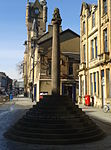
Main Street, Rutherglen Tower And Fragments Of Old Church [ de ] 55°49′43″N 4°12′55″W / 55.828601°N 4.215328°W / 55.828601; -4.215328 (Main Street, Rutherglen Tower And Fragments Of Old Church [ de] ) Category A 33563 Upload another image
41 Dalmarnock Road, Rutherglen, And 1, 3 Baronald Street Including Tennents Bar 55°50′01″N 4°12′28″W / 55.833526°N 4.207815°W / 55.833526; -4.207815 (41 Dalmarnock Road, Rutherglen, And 1, 3 Baronald Street Including Tennents Bar ) Category C(S) 33875 Upload another image
84, 86 Hamilton Road, Rutherglen, Cairn Hall 55°49′35″N 4°12′23″W / 55.826425°N 4.206343°W / 55.826425; -4.206343 (84, 86 Hamilton Road, Rutherglen, Cairn Hall ) Category C(S) 33555 Upload another image
Maccallum Avenue, Rutherglen, Stonelaw High School, Gallowflat Annexe (East Block) 55°49′37″N 4°12′20″W / 55.827041°N 4.205612°W / 55.827041; -4.205612 (Maccallum Avenue, Rutherglen, Stonelaw High School, Gallowflat Annexe (East Block) ) Category B 33557 63, 65 Main Street, Rutherglen, Narplan House 55°49′43″N 4°13′02″W / 55.828593°N 4.21726°W / 55.828593; -4.21726 (63, 65 Main Street, Rutherglen, Narplan House ) Category C(S) 33559 Upload another image
Main Street, Rutherglen, Statue To Dr Gorman 55°49′42″N 4°12′58″W / 55.8284°N 4.215987°W / 55.8284; -4.215987 (Main Street, Rutherglen, Statue To Dr Gorman ) Category B 33560 Upload another image