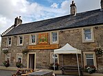
Name Location Date Listed Grid Ref. [note 1] Geo-coordinates Notes LB Number [note 2] Image Montgomery Street, Montgomerie Arms Hotel, Loupin-On-Stane 55°45′54″N 4°10′33″W / 55.764981°N 4.175961°W / 55.764981; -4.175961 (Montgomery Street, Montgomerie Arms Hotel, Loupin-On-Stane ) Category B 26611 Upload Photo Stuart Street, Wellbeck House, Including Boundary Walls And Mews Cottages Numbered 1-4 (Inclusive) 55°45′53″N 4°10′25″W / 55.764617°N 4.173662°W / 55.764617; -4.173662 (Stuart Street, Wellbeck House, Including Boundary Walls And Mews Cottages Numbered 1-4 (Inclusive) ) Category B 26616 Upload Photo 15-17 (Odd Nos) Montgomery Street 55°45′55″N 4°10′35″W / 55.765242°N 4.176438°W / 55.765242; -4.176438 (15-17 (Odd Nos) Montgomery Street ) Category C(S) 26617 Upload Photo Kittochside, Carmunnock Road, Dykehead Farm, Kittochside, Including Outbuildings Gatepiers With Boundary Wall 55°46′40″N 4°12′33″W / 55.777858°N 4.20929°W / 55.777858; -4.20929 (Kittochside, Carmunnock Road, Dykehead Farm, Kittochside, Including Outbuildings Gatepiers With Boundary Wall ) Category B 26623 Upload Photo 1A, 1B, 1C Maxwelton Road 55°46′36″N 4°08′56″W / 55.776656°N 4.148883°W / 55.776656; -4.148883 (1A, 1B, 1C Maxwelton Road ) Category B 26608 Upload Photo Newhouse 55°44′42″N 4°14′17″W / 55.744903°N 4.23797°W / 55.744903; -4.23797 (Newhouse ) Category B 1009 Upload Photo Lawside 55°44′39″N 4°14′41″W / 55.744178°N 4.244732°W / 55.744178; -4.244732 (Lawside ) Category B 1016 Upload Photo Flatt Bridge 55°44′18″N 4°09′15″W / 55.738271°N 4.154036°W / 55.738271; -4.154036 (Flatt Bridge ) Category C(S) 100 Upload Photo Calderglen Country Park (Formerly Torrance House Estate), Bridge 55°45′00″N 4°09′06″W / 55.74996°N 4.151637°W / 55.74996; -4.151637 (Calderglen Country Park (Formerly Torrance House Estate), Bridge ) Category C(S) 48651 Upload Photo Calderglen Country Park , (Formerly Torrance House Estate), Gatelodge, Gatepiers And Boundary Wall 55°45′01″N 4°09′08″W / 55.750302°N 4.152118°W / 55.750302; -4.152118 (Calderglen Country Park, (Formerly Torrance House Estate), Gatelodge, Gatepiers And Boundary Wall ) Category C(S) 48652 Upload Photo 8-12 (Even Nos) Hunter Street 55°45′55″N 4°10′31″W / 55.765344°N 4.175264°W / 55.765344; -4.175264 (8-12 (Even Nos) Hunter Street ) Category C(S) 48655 Upload Photo 96 And 98 Mains Street, Former Parish Council Chambers With Gatepiers And Boundary Wall 55°46′05″N 4°10′34″W / 55.768098°N 4.17604°W / 55.768098; -4.17604 (96 And 98 Mains Street, Former Parish Council Chambers With Gatepiers And Boundary Wall ) Category C(S) 48656 Upload Photo 114-118 (Even Nos) Maxwelton Avenue 55°46′07″N 4°09′46″W / 55.768549°N 4.162721°W / 55.768549; -4.162721 (114-118 (Even Nos) Maxwelton Avenue ) Category C(S) 48666 Upload Photo 16-22 (Even Nos) Montgomery Street, William Hill (16) And Montgomery House (18-22) 55°45′55″N 4°10′34″W / 55.765364°N 4.176158°W / 55.765364; -4.176158 (16-22 (Even Nos) Montgomery Street, William Hill (16) And Montgomery House (18-22) ) Category C(S) 48674 Upload Photo 8-12 (Even Nos) Langland Place, Auldhouse Arms 55°43′34″N 4°11′31″W / 55.726232°N 4.191864°W / 55.726232; -4.191864 (8-12 (Even Nos) Langland Place, Auldhouse Arms ) Category C(S) 51123 Upload Photo 101 Maxwelton Avenue 55°46′08″N 4°09′42″W / 55.768839°N 4.161589°W / 55.768839; -4.161589 (101 Maxwelton Avenue ) Category C(S) 26609 Upload Photo Montgomery Street, Montgomerie Arms Hotel 55°45′54″N 4°10′33″W / 55.764966°N 4.175785°W / 55.764966; -4.175785 (Montgomery Street, Montgomerie Arms Hotel ) Category B 26610 Upload another image
3-5 (Odd Nos) Montgomery Street 55°45′54″N 4°10′34″W / 55.765041°N 4.176124°W / 55.765041; -4.176124 (3-5 (Odd Nos) Montgomery Street ) Category B 26612 Upload Photo 10 -14 (Even Nos) Montgomery Street 55°45′55″N 4°10′34″W / 55.765322°N 4.175981°W / 55.765322; -4.175981 (10 -14 (Even Nos) Montgomery Street ) Category B 26614 Upload Photo Calderglen Country Park (Formerly Torrance House Estate), Statue Of Sir John Falstaff 55°44′56″N 4°08′48″W / 55.748895°N 4.146766°W / 55.748895; -4.146766 (Calderglen Country Park (Formerly Torrance House Estate), Statue Of Sir John Falstaff ) Category C(S) 26625 Upload Photo Mains Road, Mains Castle 55°46′41″N 4°11′21″W / 55.778164°N 4.18923°W / 55.778164; -4.18923 (Mains Road, Mains Castle ) Category A 26626 Upload another image See more images
8 Glebe Street 55°45′53″N 4°10′32″W / 55.764798°N 4.175648°W / 55.764798; -4.175648 (8 Glebe Street ) Category B 26628 Upload Photo Crossbasket 55°47′00″N 4°07′40″W / 55.783442°N 4.127646°W / 55.783442; -4.127646 (Crossbasket ) Category A 1004 Upload another image
Dripps Mill House 55°46′08″N 4°16′55″W / 55.768962°N 4.282012°W / 55.768962; -4.282012 (Dripps Mill House ) Category C(S) 1012 Upload Photo Dripps Mill 55°46′10″N 4°16′55″W / 55.769394°N 4.281958°W / 55.769394; -4.281958 (Dripps Mill ) Category B 1013 Upload Photo Bystone Mews 55°46′36″N 4°14′57″W / 55.77665°N 4.249134°W / 55.77665; -4.249134 (Bystone Mews ) Category C(S) 1022 Upload Photo Newhousemill Road, Newhousemill Cottages 55°45′21″N 4°08′50″W / 55.755823°N 4.147338°W / 55.755823; -4.147338 (Newhousemill Road, Newhousemill Cottages ) Category C(S) 48677 Upload Photo Kittochside Road, Castlehill (Including Walled Garden, Gatepiers And Boundary Walls) And Castlehill Steading 55°46′41″N 4°13′02″W / 55.778085°N 4.217196°W / 55.778085; -4.217196 (Kittochside Road, Castlehill (Including Walled Garden, Gatepiers And Boundary Walls) And Castlehill Steading ) Category B 26621 Upload Photo Kittochside, Carmunnock Road, Kittochside Cottages 55°46′42″N 4°12′51″W / 55.778401°N 4.214089°W / 55.778401; -4.214089 (Kittochside, Carmunnock Road, Kittochside Cottages ) Category B 26622 Upload Photo 181 Maxwelton Avenue, Alma, Including Gatepiers And Boundary Walls 55°46′02″N 4°09′49″W / 55.767257°N 4.163654°W / 55.767257; -4.163654 (181 Maxwelton Avenue, Alma, Including Gatepiers And Boundary Walls ) Category B 1025 Upload Photo Craig Mill, Packhorse Bridge, And Mill Dam 55°43′46″N 4°13′38″W / 55.729471°N 4.227148°W / 55.729471; -4.227148 (Craig Mill, Packhorse Bridge, And Mill Dam ) Category B 1015 Upload Photo North Craighall Farm 55°44′31″N 4°14′28″W / 55.742032°N 4.241183°W / 55.742032; -4.241183 (North Craighall Farm ) Category B 1018 Upload Photo 103-105 (Odd Nos) Maxwelton Avenue 55°46′08″N 4°09′42″W / 55.768764°N 4.161776°W / 55.768764; -4.161776 (103-105 (Odd Nos) Maxwelton Avenue ) Category C(S) 48658 Upload Photo 115-121 (Odd Nos) Maxwelton Avenue 55°46′07″N 4°09′44″W / 55.768595°N 4.162165°W / 55.768595; -4.162165 (115-121 (Odd Nos) Maxwelton Avenue ) Category C(S) 48661 Upload Photo 136-140 (Even Nos) Maxwelton Avenue 55°46′06″N 4°09′47″W / 55.768444°N 4.163066°W / 55.768444; -4.163066 (136-140 (Even Nos) Maxwelton Avenue ) Category C(S) 48667 Upload Photo Montgomery Street, Old Parish Church 55°45′53″N 4°10′35″W / 55.764767°N 4.17638°W / 55.764767; -4.17638 (Montgomery Street, Old Parish Church ) Category B 26615 Upload another image
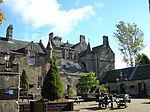
Calderglen Country Park, Rangers Office (Formerly Torrance House Stables) 55°44′54″N 4°08′43″W / 55.748383°N 4.145208°W / 55.748383; -4.145208 (Calderglen Country Park, Rangers Office (Formerly Torrance House Stables) ) Category B 26624 Upload Photo Philipshill Hospital Chapel 55°46′17″N 4°13′48″W / 55.771454°N 4.230005°W / 55.771454; -4.230005 (Philipshill Hospital Chapel ) Category B 1026 Upload Photo The Peel, Lodge 55°46′38″N 4°14′35″W / 55.777096°N 4.242941°W / 55.777096; -4.242941 (The Peel, Lodge ) Category B 1007 Upload Photo Cleughearn Lodge 55°42′31″N 4°11′05″W / 55.708691°N 4.184689°W / 55.708691; -4.184689 (Cleughearn Lodge ) Category B 1011 Upload Photo 1 And 1A Hunter Street And 2 Stuart Street 55°45′55″N 4°10′29″W / 55.765319°N 4.174657°W / 55.765319; -4.174657 (1 And 1A Hunter Street And 2 Stuart Street ) Category C(S) 47265 Upload Photo Calderglen Country Park (Formerly Torrance House Estate), Gatepiers 55°44′57″N 4°08′46″W / 55.749034°N 4.146041°W / 55.749034; -4.146041 (Calderglen Country Park (Formerly Torrance House Estate), Gatepiers ) Category C(S) 48653 Upload Photo Calderglen Country Park, (Formerly Torrance House Estate), Torrance House And Courtyard 55°44′55″N 4°08′41″W / 55.748482°N 4.144704°W / 55.748482; -4.144704 (Calderglen Country Park, (Formerly Torrance House Estate), Torrance House And Courtyard ) Category A 48654 Upload another image
107-111 (0Dd Nos) Maxwelton Avenue 55°46′07″N 4°09′43″W / 55.768699°N 4.161884°W / 55.768699; -4.161884 (107-111 (0Dd Nos) Maxwelton Avenue ) Category C(S) 48659 Upload Photo 142 Maxwelton Avenue 55°46′06″N 4°09′47″W / 55.768273°N 4.163104°W / 55.768273; -4.163104 (142 Maxwelton Avenue ) Category C(S) 48668 Upload Photo 146 Maxwelton Avenue 55°46′05″N 4°09′48″W / 55.768151°N 4.163384°W / 55.768151; -4.163384 (146 Maxwelton Avenue ) Category C(S) 48670 Upload Photo 9 Montgomery Street And Boundary Wall 55°45′54″N 4°10′35″W / 55.765073°N 4.176381°W / 55.765073; -4.176381 (9 Montgomery Street And Boundary Wall ) Category B 26613 Upload another image
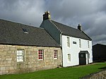
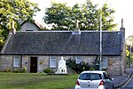
12 Graham Avenue, Former Toll House 55°46′02″N 4°10′53″W / 55.76721°N 4.181506°W / 55.76721; -4.181506 (12 Graham Avenue, Former Toll House ) Category C(S) 26629 Upload Photo Maxwelton Road, The Hunter Museum (Formerly Hunter House) , Including Gatepiers And Boundary Wall 55°46′36″N 4°09′01″W / 55.77672°N 4.150337°W / 55.77672; -4.150337 (Maxwelton Road, The Hunter Museum (Formerly Hunter House), Including Gatepiers And Boundary Wall ) Category A 26607 Upload another image See more images
The Peel 55°46′40″N 4°14′41″W / 55.777883°N 4.244629°W / 55.777883; -4.244629 (The Peel ) Category A 1005 Upload another image
The Peel, Stable Or Barn 55°46′39″N 4°14′38″W / 55.777412°N 4.243852°W / 55.777412; -4.243852 (The Peel, Stable Or Barn ) Category A 1006 Upload Photo 123-127 (Odd Nos) Maxwelton Avenue 55°46′07″N 4°09′44″W / 55.768494°N 4.162287°W / 55.768494; -4.162287 (123-127 (Odd Nos) Maxwelton Avenue ) Category C(S) 48662 Upload Photo Montgomery Street, Old Parish Church, Kirkyard, Gateway, Boundary Wall, Railings, Session House And Stuarts Of Torrance Mausoleum 55°45′52″N 4°10′35″W / 55.764534°N 4.176351°W / 55.764534; -4.176351 (Montgomery Street, Old Parish Church, Kirkyard, Gateway, Boundary Wall, Railings, Session House And Stuarts Of Torrance Mausoleum ) Category B 48672 Upload Photo 24 Montgomery Street 55°45′56″N 4°10′34″W / 55.765533°N 4.176247°W / 55.765533; -4.176247 (24 Montgomery Street ) Category C(S) 48676 Upload Photo Calderstone House 55°44′08″N 4°09′23″W / 55.735462°N 4.15635°W / 55.735462; -4.15635 (Calderstone House ) Category B 50796 Upload Photo Markethill Road, Laigh Markethill Cottage 55°46′08″N 4°10′40″W / 55.768911°N 4.17787°W / 55.768911; -4.17787 (Markethill Road, Laigh Markethill Cottage ) Category B 26620 Upload another image
Waterside House, Including Gates, Gatepiers And Boundary Wall 55°46′47″N 4°14′15″W / 55.779586°N 4.237502°W / 55.779586; -4.237502 (Waterside House, Including Gates, Gatepiers And Boundary Wall ) Category C(S) 6614 Upload Photo Gill 55°45′13″N 4°14′59″W / 55.753675°N 4.249803°W / 55.753675; -4.249803 (Gill ) Category C(S) 4875 Upload Photo Kirkland Bridge 55°44′49″N 4°15′19″W / 55.74687°N 4.255243°W / 55.74687; -4.255243 (Kirkland Bridge ) Category C(S) 1010 Upload another image See more images
Millbrae (Now Renamed Bryans) 55°45′39″N 4°13′59″W / 55.760872°N 4.233163°W / 55.760872; -4.233163 (Millbrae (Now Renamed Bryans) ) Category B 1017 Upload Photo Blackburn Mill 55°42′00″N 4°05′31″W / 55.699933°N 4.092056°W / 55.699933; -4.092056 (Blackburn Mill ) Category B 1019 Upload Photo Bystone Lodge 55°46′36″N 4°14′55″W / 55.776766°N 4.24871°W / 55.776766; -4.24871 (Bystone Lodge ) Category B 1021 Upload Photo 19 Montgomery Street 55°45′55″N 4°10′35″W / 55.76534°N 4.176476°W / 55.76534; -4.176476 (19 Montgomery Street ) Category C(S) 48673 Upload Photo Old Coach Road, Old Toll House 55°46′08″N 4°10′37″W / 55.76889°N 4.177008°W / 55.76889; -4.177008 (Old Coach Road, Old Toll House ) Category C(S) 48680 Upload Photo Brousterhill, Brousterlands 55°45′49″N 4°10′40″W / 55.76368°N 4.17785°W / 55.76368; -4.17785 (Brousterhill, Brousterlands ) Category A 26619 Upload another image
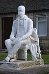
Newhousemill Road, Newhouse House And Outbuildings 55°45′23″N 4°08′46″W / 55.756323°N 4.145995°W / 55.756323; -4.145995 (Newhousemill Road, Newhouse House And Outbuildings ) Category B 26627 Upload Photo Stoneymeadow Road, General's Bridge 55°46′57″N 4°07′43″W / 55.782417°N 4.128722°W / 55.782417; -4.128722 (Stoneymeadow Road, General's Bridge ) Category B 26606 Upload Photo Wester Kittochside , Including Farmhouse, Steading, Dutch Barns, Boundary Walls And Gatepiers 55°46′49″N 4°13′14″W / 55.780208°N 4.220538°W / 55.780208; -4.220538 (Wester Kittochside, Including Farmhouse, Steading, Dutch Barns, Boundary Walls And Gatepiers ) Category A 1008 Upload Photo Bystone House 55°46′33″N 4°14′55″W / 55.775956°N 4.248744°W / 55.775956; -4.248744 (Bystone House ) Category B 1020 Upload Photo Markethill Road, Statue Of Sir Walter Scott 55°46′08″N 4°10′40″W / 55.768832°N 4.17777°W / 55.768832; -4.17777 (Markethill Road, Statue Of Sir Walter Scott ) Category C(S) 48657 Upload another image
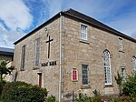
106 Maxwelton Avenue 55°46′08″N 4°09′44″W / 55.768801°N 4.162225°W / 55.768801; -4.162225 (106 Maxwelton Avenue ) Category C(S) 48664 Upload Photo 144 Maxwelton Avenue 55°46′06″N 4°09′48″W / 55.768199°N 4.163227°W / 55.768199; -4.163227 (144 Maxwelton Avenue ) Category C(S) 48669 Upload Photo Newhousemill Road, Newhouse Bridge 55°45′18″N 4°08′43″W / 55.755085°N 4.145385°W / 55.755085; -4.145385 (Newhousemill Road, Newhouse Bridge ) Category B 48678 Upload Photo 4 Newlands Place 55°45′43″N 4°10′45″W / 55.761862°N 4.179039°W / 55.761862; -4.179039 (4 Newlands Place ) Category C(S) 48679 Upload Photo Priestknowe Roundabout, Hunter Memorial 55°45′51″N 4°10′24″W / 55.764095°N 4.173234°W / 55.764095; -4.173234 (Priestknowe Roundabout, Hunter Memorial ) Category B 48681 Upload Photo Kittoch Street, West Kirk 55°45′57″N 4°10′41″W / 55.765924°N 4.178055°W / 55.765924; -4.178055 (Kittoch Street, West Kirk ) Category B 26618 Upload another image
Whitemoss Avenue, St Bride's Roman Catholic Church , Including Presbytery And Ancillary Buildings 55°45′47″N 4°10′06″W / 55.762923°N 4.168307°W / 55.762923; -4.168307 (Whitemoss Avenue, St Bride's Roman Catholic Church, Including Presbytery And Ancillary Buildings ) Category A 26630 Upload Photo Braehead Farm, Braehead Road 55°46′18″N 4°14′13″W / 55.771704°N 4.237003°W / 55.771704; -4.237003 (Braehead Farm, Braehead Road ) Category B 6686 Upload Photo Crag Tower, 1 Wellknowe Road, Thorntonhall 55°46′13″N 4°14′48″W / 55.77037°N 4.246588°W / 55.77037; -4.246588 (Crag Tower, 1 Wellknowe Road, Thorntonhall ) Category B 6404 Upload Photo Waterfoot Bridge 55°46′10″N 4°16′54″W / 55.769559°N 4.281776°W / 55.769559; -4.281776 (Waterfoot Bridge ) Category B 1014 Upload Photo 129 Maxwelton Avenue 55°46′06″N 4°09′45″W / 55.768401°N 4.162458°W / 55.768401; -4.162458 (129 Maxwelton Avenue ) Category C(S) 48663 Upload Photo 110 Maxwelton Avenue 55°46′07″N 4°09′45″W / 55.768632°N 4.16263°W / 55.768632; -4.16263 (110 Maxwelton Avenue ) Category C(S) 48665 Upload Photo Town Centre Park, Dollan Aqua Centre 55°45′43″N 4°10′57″W / 55.761919°N 4.18239°W / 55.761919; -4.18239 (Town Centre Park, Dollan Aqua Centre ) Category A 48682 Upload another image