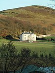
Name Location Date Listed Grid Ref. [note 1] Geo-coordinates Notes LB Number [note 2] Image Castle Moffat, Steading 55°54′59″N 2°38′18″W / 55.916448°N 2.63845°W / 55.916448; -2.63845 (Castle Moffat, Steading ) Category B 7328 Garvald, Main Street, Garvald Hotel 55°55′43″N 2°39′41″W / 55.92851°N 2.661454°W / 55.92851; -2.661454 (Garvald, Main Street, Garvald Hotel ) Category B 7333 Garvald, Main Street, Mulberry And Glen Cottages 55°55′42″N 2°39′43″W / 55.928408°N 2.662012°W / 55.928408; -2.662012 (Garvald, Main Street, Mulberry And Glen Cottages ) Category C(S) 7335 Garvald, Main Street, Rowans And Retaining Walls And Gatepiers 55°55′42″N 2°39′49″W / 55.9283°N 2.663739°W / 55.9283; -2.663739 (Garvald, Main Street, Rowans And Retaining Walls And Gatepiers ) Category B 7336 Garvald, Manse And Stables 55°55′46″N 2°39′27″W / 55.929385°N 2.657388°W / 55.929385; -2.657388 (Garvald, Manse And Stables ) Category B 7340 Newlands Farmhouse 55°53′21″N 2°41′20″W / 55.889247°N 2.689005°W / 55.889247; -2.689005 (Newlands Farmhouse ) Category B 7319 West Hopes Farmhouse 55°51′22″N 2°42′31″W / 55.856224°N 2.708548°W / 55.856224; -2.708548 (West Hopes Farmhouse ) Category C(S) 7325 Castlemains Farmhouse 55°53′17″N 2°42′43″W / 55.888084°N 2.711831°W / 55.888084; -2.711831 (Castlemains Farmhouse ) Category C(S) 7326 Danskine, East Lodge (Formerly To Yester House) 55°53′50″N 2°41′43″W / 55.897218°N 2.695207°W / 55.897218; -2.695207 (Danskine, East Lodge (Formerly To Yester House) ) Category C(S) 13403 Garvald, Main Street, Logansland And Retaining Wall 55°55′43″N 2°39′38″W / 55.928649°N 2.660656°W / 55.928649; -2.660656 (Garvald, Main Street, Logansland And Retaining Wall ) Category B 7334 Garvald, Main Street, Village Hall (Former Free Church) With Retaining Walls 55°55′43″N 2°39′47″W / 55.928663°N 2.663009°W / 55.928663; -2.663009 (Garvald, Main Street, Village Hall (Former Free Church) With Retaining Walls ) Category C(S) 7338 Castle Moffat, Cottages 55°54′58″N 2°38′16″W / 55.916065°N 2.637723°W / 55.916065; -2.637723 (Castle Moffat, Cottages ) Category B 7327 Garvald, Main Street, Brookside And Juniper Cottage 55°55′44″N 2°39′30″W / 55.928796°N 2.658354°W / 55.928796; -2.658354 (Garvald, Main Street, Brookside And Juniper Cottage ) Category C(S) 7331 Garvald, Main Street, Tree Tops 55°55′44″N 2°39′31″W / 55.928903°N 2.658644°W / 55.928903; -2.658644 (Garvald, Main Street, Tree Tops ) Category B 7337 East Hopes Steading 55°51′54″N 2°42′24″W / 55.865112°N 2.706585°W / 55.865112; -2.706585 (East Hopes Steading ) Category B 7343 Linplum (Limplum) House 55°55′29″N 2°42′51″W / 55.924756°N 2.714167°W / 55.924756; -2.714167 (Linplum (Limplum) House ) Category B 7344 Garvald, Main Street, Broomfield 55°55′43″N 2°39′45″W / 55.928532°N 2.662399°W / 55.928532; -2.662399 (Garvald, Main Street, Broomfield ) Category C(S) 7332 Garvald Parish Church (Church Of Scotland) 55°55′46″N 2°39′24″W / 55.929488°N 2.656701°W / 55.929488; -2.656701 (Garvald Parish Church (Church Of Scotland) ) Category B 7341 Hopes House With Gates And Gatepiers 55°51′57″N 2°42′10″W / 55.865835°N 2.702699°W / 55.865835; -2.702699 (Hopes House With Gates And Gatepiers ) Category A 7342 Upload another image
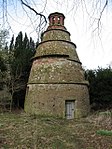
Tanderlane Cottage 55°55′54″N 2°40′15″W / 55.931801°N 2.670921°W / 55.931801; -2.670921 (Tanderlane Cottage ) Category C(S) 7324 Linplum Lodge 55°55′26″N 2°43′01″W / 55.923868°N 2.717047°W / 55.923868; -2.717047 (Linplum Lodge ) Category B 7318 Snawdon Cartshed And Granary 55°54′04″N 2°40′02″W / 55.901084°N 2.667128°W / 55.901084; -2.667128 (Snawdon Cartshed And Granary ) Category B 7323 Danskine Gateway 55°53′51″N 2°41′44″W / 55.897449°N 2.695627°W / 55.897449; -2.695627 (Danskine Gateway ) Category A 7329 Garvald, Main Street, Ashley Cottage 55°55′44″N 2°39′29″W / 55.928932°N 2.6581°W / 55.928932; -2.6581 (Garvald, Main Street, Ashley Cottage ) Category B 7330 Garvald, Main Street, Whitelaws With Retaining Walls 55°55′44″N 2°39′33″W / 55.928891°N 2.659172°W / 55.928891; -2.659172 (Garvald, Main Street, Whitelaws With Retaining Walls ) Category B 7339 Nunraw Dovecot 55°55′39″N 2°38′46″W / 55.927559°N 2.64601°W / 55.927559; -2.64601 (Nunraw Dovecot ) Category A 7320 Upload another image
Nunraw Old Abbey With Sundial 55°55′35″N 2°38′43″W / 55.926304°N 2.645413°W / 55.926304; -2.645413 (Nunraw Old Abbey With Sundial ) Category A 7321 Upload another image
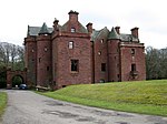
Baro House With Boundary Walls, Gates And Gatepiers 55°55′06″N 2°41′55″W / 55.918241°N 2.698671°W / 55.918241; -2.698671 (Baro House With Boundary Walls, Gates And Gatepiers ) Category B 7346 Nunraw Old Abbey, North Lodge And Gate 55°55′36″N 2°39′21″W / 55.926698°N 2.65587°W / 55.926698; -2.65587 (Nunraw Old Abbey, North Lodge And Gate ) Category B 7322 Baro Farmhouse With Garden Walls 55°55′13″N 2°42′18″W / 55.920272°N 2.705044°W / 55.920272; -2.705044 (Baro Farmhouse With Garden Walls ) Category B 7345