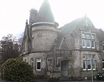
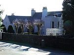
Name Location Date Listed Grid Ref. [note 1] Geo-coordinates Notes LB Number [note 2] Image Finlaystone House , Port Glasgow Road, By Langbank 55°55′43″N 4°37′09″W / 55.928627°N 4.619233°W / 55.928627; -4.619233 (Finlaystone House, Port Glasgow Road, By Langbank ) Category A 13641 Upload another image
Balrossie With Annex, Ornamental Outbuilding, Ancillary Building, Terraces, Steps, Gatepiers, Gates And Railings 55°53′16″N 4°39′10″W / 55.88772°N 4.652845°W / 55.88772; -4.652845 (Balrossie With Annex, Ornamental Outbuilding, Ancillary Building, Terraces, Steps, Gatepiers, Gates And Railings ) Category B 49972 Bridge Of Weir, 28 Quarrier's Village, (Sabbath School Home) 55°52′03″N 4°37′11″W / 55.867397°N 4.619728°W / 55.867397; -4.619728 (Bridge Of Weir, 28 Quarrier's Village, (Sabbath School Home) ) Category C(S) 50588 Upload another image
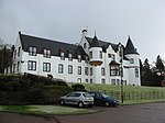
Bridge Of Weir Hospital Main Block Including Chapel 55°51′48″N 4°36′48″W / 55.863354°N 4.613318°W / 55.863354; -4.613318 (Bridge Of Weir Hospital Main Block Including Chapel ) Category B 13232 "Overton", Glen Road, Kilmacolm 55°53′46″N 4°37′03″W / 55.896226°N 4.617432°W / 55.896226; -4.617432 ("Overton", Glen Road, Kilmacolm ) Category C(S) 12457 Duchal House , Strathgryfe, By Kilmacolm 55°52′37″N 4°38′01″W / 55.877043°N 4.633569°W / 55.877043; -4.633569 (Duchal House, Strathgryfe, By Kilmacolm ) Category A 12463 Bridge Of Weir, 17 Quarrier's Village, 'Alan Dick Home' 55°52′04″N 4°37′03″W / 55.867892°N 4.617587°W / 55.867892; -4.617587 (Bridge Of Weir, 17 Quarrier's Village, 'Alan Dick Home' ) Category C(S) 50584 Bridge Of Weir, 34 Quarrier's Village, (Glenfarg) 55°52′03″N 4°36′45″W / 55.867382°N 4.612406°W / 55.867382; -4.612406 (Bridge Of Weir, 34 Quarrier's Village, (Glenfarg) ) Category C(S) 50586 Kilmacolm Cemetery, Headstone For James Reid 55°54′06″N 4°38′03″W / 55.901605°N 4.63413°W / 55.901605; -4.63413 (Kilmacolm Cemetery, Headstone For James Reid ) Category B 51677 Kilmacolm Parish Church ("Old Kirk"), Main Street, Kilmacolm 55°53′42″N 4°37′37″W / 55.894947°N 4.62688°W / 55.894947; -4.62688 (Kilmacolm Parish Church ("Old Kirk"), Main Street, Kilmacolm ) Category B 12447 Upload another image See more images
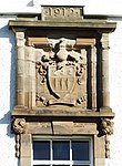
Kidston Hall, Port Glasgow Road, Kilmacolm 55°53′43″N 4°37′38″W / 55.895299°N 4.627208°W / 55.895299; -4.627208 (Kidston Hall, Port Glasgow Road, Kilmacolm ) Category C(S) 12458 Upload another image See more images
Knockbuckle Road, Shallott, St Columba's Junior School With Terrace, Statue, Boundary Wall, Gatepiers And Gates 55°53′32″N 4°38′09″W / 55.892337°N 4.635853°W / 55.892337; -4.635853 (Knockbuckle Road, Shallott, St Columba's Junior School With Terrace, Statue, Boundary Wall, Gatepiers And Gates ) Category B 50020 Quarrier's Village, Faith Avenue, Homelea 55°52′00″N 4°36′59″W / 55.866616°N 4.616303°W / 55.866616; -4.616303 (Quarrier's Village, Faith Avenue, Homelea ) Category C(S) 50021 The Cross And Lochwinnoch Road, Old Primary School With Boundary Wall 55°53′37″N 4°37′38″W / 55.893655°N 4.627193°W / 55.893655; -4.627193 (The Cross And Lochwinnoch Road, Old Primary School With Boundary Wall ) Category C(S) 50022 Upload another image
Bridge Of Weir, 45 Quarrier's Village, (Bethesda') 55°52′00″N 4°37′02″W / 55.866783°N 4.617337°W / 55.866783; -4.617337 (Bridge Of Weir, 45 Quarrier's Village, (Bethesda') ) Category C(S) 50585 Bridge Of Weir, 14 Quarrier's Village, 'Overtoun' 55°52′02″N 4°37′08″W / 55.867281°N 4.618841°W / 55.867281; -4.618841 (Bridge Of Weir, 14 Quarrier's Village, 'Overtoun' ) Category C(S) 50587 Bridge Of Weir, 48 Quarrier's Village, The Marcus Humphrey House (Former Elise Hospital) 55°52′04″N 4°37′15″W / 55.867884°N 4.620928°W / 55.867884; -4.620928 (Bridge Of Weir, 48 Quarrier's Village, The Marcus Humphrey House (Former Elise Hospital) ) Category C(S) 50589 "Windyhill", Rowantreehill Road Kilmacolm 55°53′24″N 4°37′13″W / 55.890078°N 4.620409°W / 55.890078; -4.620409 ("Windyhill", Rowantreehill Road Kilmacolm ) Category A 12450 Upload another image
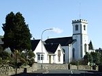
Quarrier's Village , Mount Zion Church, Including Cemetery And Boundary Walls 55°52′07″N 4°37′04″W / 55.868578°N 4.617873°W / 55.868578; -4.617873 (Quarrier's Village, Mount Zion Church, Including Cemetery And Boundary Walls ) Category B 48940 Upload another image See more images
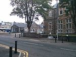
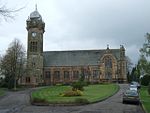
St. Columba's (Formerly St. James's) Church Of Scotland Duchal Road, Kilmacolm 55°53′35″N 4°37′37″W / 55.892949°N 4.626969°W / 55.892949; -4.626969 (St. Columba's (Formerly St. James's) Church Of Scotland Duchal Road, Kilmacolm ) Category A 12448 "Rowantreehill", Rowantreehill Road, Kilmacolm 55°53′26″N 4°37′15″W / 55.890592°N 4.620748°W / 55.890592; -4.620748 ("Rowantreehill", Rowantreehill Road, Kilmacolm ) Category B 12449 "Hazelhope", Gryffe Road, Kilmacolm 55°53′13″N 4°37′24″W / 55.886825°N 4.623324°W / 55.886825; -4.623324 ("Hazelhope", Gryffe Road, Kilmacolm ) Category C(S) 12454 Lodge Of Auchenbothie House, Port Glasgow Road, By Kilmacolm 55°54′00″N 4°38′16″W / 55.900008°N 4.637749°W / 55.900008; -4.637749 (Lodge Of Auchenbothie House, Port Glasgow Road, By Kilmacolm ) Category B 12461 Stable Block With Coachman's Cottage, Etc., At Duchal House 55°52′37″N 4°38′06″W / 55.877067°N 4.634929°W / 55.877067; -4.634929 (Stable Block With Coachman's Cottage, Etc., At Duchal House ) Category B 12464 Hope Lodge, ( Originally Lodge To Bridge Of Weir Hospital) 55°51′47″N 4°36′23″W / 55.863044°N 4.606297°W / 55.863044; -4.606297 (Hope Lodge, ( Originally Lodge To Bridge Of Weir Hospital) ) Category B 13230 "Greystones", Houston Road, Kilmacolm 55°53′13″N 4°37′01″W / 55.886862°N 4.616962°W / 55.886862; -4.616962 ("Greystones", Houston Road, Kilmacolm ) Category B 12453 "Nether Knockbuckle", Knockbuckle, Kilmacolm 55°53′33″N 4°38′44″W / 55.892454°N 4.645474°W / 55.892454; -4.645474 ("Nether Knockbuckle", Knockbuckle, Kilmacolm ) Category B 12456 Auchenbothie House, (Former Old Folks Home), Port Glasgow Road, By Kilmacolm 55°54′12″N 4°38′27″W / 55.903305°N 4.640757°W / 55.903305; -4.640757 (Auchenbothie House, (Former Old Folks Home), Port Glasgow Road, By Kilmacolm ) Category B 12460 Upload another image See more images
"Cloak", (Formerly "Mosside"), Cloak Road, By Kilmacolm 55°54′46″N 4°38′12″W / 55.912722°N 4.636725°W / 55.912722; -4.636725 ("Cloak", (Formerly "Mosside"), Cloak Road, By Kilmacolm ) Category B 12462 Former R.C. "Bishop's House", (Formerly "Miyanoshta") Porterfield Road, Kilmacolm 55°53′20″N 4°37′12″W / 55.888927°N 4.619996°W / 55.888927; -4.619996 (Former R.C. "Bishop's House", (Formerly "Miyanoshta") Porterfield Road, Kilmacolm ) Category B 12451 Upload another image
Craigbet, By Torr Road, Bridge Of Weir 55°51′51″N 4°36′23″W / 55.864115°N 4.606256°W / 55.864115; -4.606256 (Craigbet, By Torr Road, Bridge Of Weir ) Category B 13047 "Knapps House", Houston Road, Kilmacolm 55°53′12″N 4°36′47″W / 55.886666°N 4.613062°W / 55.886666; -4.613062 ("Knapps House", Houston Road, Kilmacolm ) Category B 12452 "Den O' Gryffe", Knockbuckle Road, Kilmacolm 55°53′35″N 4°38′51″W / 55.893022°N 4.647496°W / 55.893022; -4.647496 ("Den O' Gryffe", Knockbuckle Road, Kilmacolm ) Category B 12455 "Water Yetts", Finlaystone Road, Kilmacolm 55°54′00″N 4°37′40″W / 55.899882°N 4.627694°W / 55.899882; -4.627694 ("Water Yetts", Finlaystone Road, Kilmacolm ) Category B 12459 Glencairn Road, Old Church Manse 55°53′34″N 4°37′20″W / 55.892681°N 4.622248°W / 55.892681; -4.622248 (Glencairn Road, Old Church Manse ) Category C(S) 50019