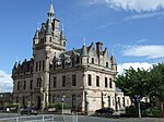
Name Location Date Listed Grid Ref. [note 1] Geo-coordinates Notes LB Number [note 2] Image Former Church Of Scotland, 25, 27 Madeira Street 55°57′24″N 4°46′44″W / 55.956626°N 4.778751°W / 55.956626; -4.778751 (Former Church Of Scotland, 25, 27 Madeira Street ) Category B 34129 Upload another image
24 And 26 Margaret Street 55°57′22″N 4°46′20″W / 55.956178°N 4.772294°W / 55.956178; -4.772294 (24 And 26 Margaret Street ) Category B 34132 County Court Buildings, Nelson Street 55°56′58″N 4°45′55″W / 55.949458°N 4.765325°W / 55.949458; -4.765325 (County Court Buildings, Nelson Street ) Category B 34133 Upload another image See more images
Lindores, 61 Newark Street 55°57′30″N 4°47′07″W / 55.958436°N 4.785354°W / 55.958436; -4.785354 (Lindores, 61 Newark Street ) Category B 34135 Sir Gabriel Wood's Mariners' Home, Newark Street (Including Front Wall Gate Etc) 55°57′33″N 4°47′14″W / 55.959281°N 4.787338°W / 55.959281; -4.787338 (Sir Gabriel Wood's Mariners' Home, Newark Street (Including Front Wall Gate Etc) ) Category A 34136 Upload another image See more images
Birnam, 88, 90 Newark Street 55°57′35″N 4°47′06″W / 55.959584°N 4.7851°W / 55.959584; -4.7851 (Birnam, 88, 90 Newark Street ) Category B 34140 Steamboat Quay, Former Harbour Trust Offices 55°56′53″N 4°44′58″W / 55.947925°N 4.749534°W / 55.947925; -4.749534 (Steamboat Quay, Former Harbour Trust Offices ) Category C(S) 34176 Clarence Street, Tobacco Warehouse 55°57′09″N 4°45′39″W / 55.95248°N 4.760847°W / 55.95248; -4.760847 (Clarence Street, Tobacco Warehouse ) Category B 34180 2 Ardgowan Square 55°57′08″N 4°46′03″W / 55.952331°N 4.767517°W / 55.952331; -4.767517 (2 Ardgowan Square ) Category C(S) 34076 9 Ardgowan Square 55°57′09″N 4°46′09″W / 55.952444°N 4.769255°W / 55.952444; -4.769255 (9 Ardgowan Square ) Category C(S) 34079 23 And 24 Ardgowan Square 55°57′05″N 4°46′09″W / 55.951296°N 4.769157°W / 55.951296; -4.769157 (23 And 24 Ardgowan Square ) Category B 34082 Keir Hardie House, 4 Brougham Street 55°57′13″N 4°45′54″W / 55.953513°N 4.764878°W / 55.953513; -4.764878 (Keir Hardie House, 4 Brougham Street ) Category B 34092 Former Clydesdale Bank, Cathcart Square And 130, 132 And 134 Cathcart Street 55°56′50″N 4°45′20″W / 55.94717°N 4.755551°W / 55.94717; -4.755551 (Former Clydesdale Bank, Cathcart Square And 130, 132 And 134 Cathcart Street ) Category B 34098 Upload another image See more images
Custom House, Custom House Place 55°56′53″N 4°45′04″W / 55.948105°N 4.7511°W / 55.948105; -4.7511 (Custom House, Custom House Place ) Category A 34100 Watt Memorial School, Dalrymple Street 55°56′52″N 4°45′19″W / 55.947884°N 4.755346°W / 55.947884; -4.755346 (Watt Memorial School, Dalrymple Street ) Category B 34101 15 Esplanade And 64 Eldon Street 55°57′34″N 4°46′29″W / 55.959466°N 4.774772°W / 55.959466; -4.774772 (15 Esplanade And 64 Eldon Street ) Category B 34108 153, 153A And 155 Finnart Street 55°57′18″N 4°46′46″W / 55.955021°N 4.779357°W / 55.955021; -4.779357 (153, 153A And 155 Finnart Street ) Category B 34111 Westburn Church, Nelson Street (Formerly The Old Kirk And St Lukes Church Of Scotland) 55°56′56″N 4°46′00″W / 55.948987°N 4.766702°W / 55.948987; -4.766702 (Westburn Church, Nelson Street (Formerly The Old Kirk And St Lukes Church Of Scotland) ) Category A 34134 Upload another image See more images
1 Shaw Place 55°56′47″N 4°45′26″W / 55.946267°N 4.757345°W / 55.946267; -4.757345 (1 Shaw Place ) Category B 34143 2 Shaw Place 55°56′47″N 4°45′27″W / 55.94628°N 4.75757°W / 55.94628; -4.75757 (2 Shaw Place ) Category B 34144 5 Shaw Place 55°56′47″N 4°45′30″W / 55.946355°N 4.7582°W / 55.946355; -4.7582 (5 Shaw Place ) Category B 34147 72 Union Street/27 Fox Street 55°57′22″N 4°46′27″W / 55.956128°N 4.774117°W / 55.956128; -4.774117 (72 Union Street/27 Fox Street ) Category B 34164 14 William Street 55°56′51″N 4°45′21″W / 55.947533°N 4.755785°W / 55.947533; -4.755785 (14 William Street ) Category B 34171 Harbour Light And Clock, Custom House 55°56′54″N 4°45′03″W / 55.948409°N 4.750769°W / 55.948409; -4.750769 (Harbour Light And Clock, Custom House ) Category B 34182 Cedars School Of Excellence, 31 Ardgowan Square (Formerly The Greenock Club) 55°57′05″N 4°46′03″W / 55.951488°N 4.767393°W / 55.951488; -4.767393 (Cedars School Of Excellence, 31 Ardgowan Square (Formerly The Greenock Club) ) Category B 34086 44 Ardgowan Street 55°57′13″N 4°46′21″W / 55.953737°N 4.772536°W / 55.953737; -4.772536 (44 Ardgowan Street ) Category B 34089 189 Eldon Street 55°57′42″N 4°47′25″W / 55.96174°N 4.790287°W / 55.96174; -4.790287 (189 Eldon Street ) Category C(S) 34104 13, 14, 15 And 16 Seafield Cottage Lane, Seafield Cottage 55°57′33″N 4°46′26″W / 55.959297°N 4.773879°W / 55.959297; -4.773879 (13, 14, 15 And 16 Seafield Cottage Lane, Seafield Cottage ) Category B 34106 Lindon Mansions, 48 Forsyth Street, (Former Glenpark Teachers Centre And Former Glenburn Special School) 55°57′14″N 4°46′26″W / 55.953884°N 4.773988°W / 55.953884; -4.773988 (Lindon Mansions, 48 Forsyth Street, (Former Glenpark Teachers Centre And Former Glenburn Special School) ) Category B 34112 Baptist Church, George Square 55°57′02″N 4°45′49″W / 55.950444°N 4.763489°W / 55.950444; -4.763489 (Baptist Church, George Square ) Category C(S) 34113 Greenock Cemetery, Including Highland Mary (Mary Campbell Monument), James Watt Cairn, Cemetery Gates And Boundary Walls 55°56′50″N 4°46′17″W / 55.947149°N 4.77128°W / 55.947149; -4.77128 (Greenock Cemetery, Including Highland Mary (Mary Campbell Monument), James Watt Cairn, Cemetery Gates And Boundary Walls ) Category B 34118 1 South Street, Greenock Crematorium 55°56′54″N 4°46′51″W / 55.948237°N 4.780841°W / 55.948237; -4.780841 (1 South Street, Greenock Crematorium ) Category C(S) 34119 Municipal Buildings, Clyde Square ( Wallace Place/Dalrymple Street) 55°56′53″N 4°45′22″W / 55.948026°N 4.756237°W / 55.948026; -4.756237 (Municipal Buildings, Clyde Square ( Wallace Place/Dalrymple Street) ) Category A 34122 Upload another image
20, 22 Margaret Street 55°57′23″N 4°46′20″W / 55.956326°N 4.772096°W / 55.956326; -4.772096 (20, 22 Margaret Street ) Category B 34131 Madeira Lodge 16 Newark Street 55°57′28″N 4°46′38″W / 55.95775°N 4.777133°W / 55.95775; -4.777133 (Madeira Lodge 16 Newark Street ) Category C(S) 34138 Ardgowan Parish Church, Union Street. (Former Trinity Church Of Scotland) 55°57′12″N 4°46′13″W / 55.953308°N 4.770406°W / 55.953308; -4.770406 (Ardgowan Parish Church, Union Street. (Former Trinity Church Of Scotland) ) Category B 34152 Upload another image
20 Union Street 55°57′06″N 4°46′00″W / 55.951758°N 4.766579°W / 55.951758; -4.766579 (20 Union Street ) Category C(S) 34157 34, 36 Union Street 55°57′13″N 4°46′11″W / 55.953727°N 4.769763°W / 55.953727; -4.769763 (34, 36 Union Street ) Category C(S) 34159 64, 66 And 66A Union Street 55°57′21″N 4°46′25″W / 55.955853°N 4.773568°W / 55.955853; -4.773568 (64, 66 And 66A Union Street ) Category B 34163 Well Park: Walls And Gates 55°56′44″N 4°45′21″W / 55.945427°N 4.755892°W / 55.945427; -4.755892 (Well Park: Walls And Gates ) Category C(S) 34165 Upload another image See more images
49-55 West Blackhall Street And 1, 3, 5 Argyle Street 55°57′02″N 4°45′43″W / 55.950544°N 4.761814°W / 55.950544; -4.761814 (49-55 West Blackhall Street And 1, 3, 5 Argyle Street ) Category B 34167 9 William Street 55°56′51″N 4°45′19″W / 55.947628°N 4.755167°W / 55.947628; -4.755167 (9 William Street ) Category B 34169 Former Greenock Provident Bank, 11 William Street 55°56′51″N 4°45′19″W / 55.947488°N 4.755398°W / 55.947488; -4.755398 (Former Greenock Provident Bank, 11 William Street ) Category B 34170 Esplanade, Cast-Iron Navigation Light 55°57′37″N 4°46′34″W / 55.960414°N 4.776202°W / 55.960414; -4.776202 (Esplanade, Cast-Iron Navigation Light ) Category B 34179 Ker Street, Glebe Sugar Refinery 55°57′11″N 4°45′46″W / 55.952988°N 4.762677°W / 55.952988; -4.762677 (Ker Street, Glebe Sugar Refinery ) Category B 34181 3, & 4 Ardgowan Square 55°57′09″N 4°46′04″W / 55.952426°N 4.767668°W / 55.952426; -4.767668 (3, & 4 Ardgowan Square ) Category C(S) 34077 37 Ardgowan Street 55°57′11″N 4°46′20″W / 55.95313°N 4.772332°W / 55.95313; -4.772332 (37 Ardgowan Street ) Category B 34088 2 Brougham Street And 12 Patrick Street 55°57′12″N 4°45′53″W / 55.953355°N 4.764722°W / 55.953355; -4.764722 (2 Brougham Street And 12 Patrick Street ) Category B 34091 8 Brougham Street 55°57′13″N 4°45′55″W / 55.953693°N 4.765291°W / 55.953693; -4.765291 (8 Brougham Street ) Category B 34094 Old West Kirk , Campbell Street, Including Church Hall, Boundary Walls And Railings 55°57′22″N 4°46′03″W / 55.956018°N 4.767412°W / 55.956018; -4.767412 (Old West Kirk, Campbell Street, Including Church Hall, Boundary Walls And Railings ) Category B 34095 Upload another image See more images
Wellpark Mid Kirk, Cathcart Square 55°56′50″N 4°45′23″W / 55.94715°N 4.756431°W / 55.94715; -4.756431 (Wellpark Mid Kirk, Cathcart Square ) Category A 34096 Upload another image See more images
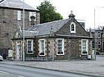
Former Royal Bank, 96 Cathcart Street And Cross Shore Street 55°56′49″N 4°45′15″W / 55.946932°N 4.754109°W / 55.946932; -4.754109 (Former Royal Bank, 96 Cathcart Street And Cross Shore Street ) Category B 34097 Old Toll House, 293 Eldon Street 55°57′31″N 4°47′54″W / 55.958718°N 4.798305°W / 55.958718; -4.798305 (Old Toll House, 293 Eldon Street ) Category B 34105 Upload another image See more images
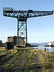
Greenock West United Reformed Church, George Square (Formerly George Square Congregational Church) 55°57′02″N 4°45′52″W / 55.950689°N 4.764548°W / 55.950689; -4.764548 (Greenock West United Reformed Church, George Square (Formerly George Square Congregational Church) ) Category B 34116 22B, 22C And 22D Esplanade And 90 Eldon Street, Firth House, With Boundary Walls And Gatepiers 55°57′36″N 4°46′39″W / 55.960071°N 4.777428°W / 55.960071; -4.777428 (22B, 22C And 22D Esplanade And 90 Eldon Street, Firth House, With Boundary Walls And Gatepiers ) Category C(S) 50050 Greenbank Institute Former Greenbank Church, Kelly Street 55°56′56″N 4°46′17″W / 55.948937°N 4.771328°W / 55.948937; -4.771328 (Greenbank Institute Former Greenbank Church, Kelly Street ) Category B 34126 St. Mary's R.C. Church And Presbytery House, 14 Patrick Street 55°57′11″N 4°45′56″W / 55.953122°N 4.765491°W / 55.953122; -4.765491 (St. Mary's R.C. Church And Presbytery House, 14 Patrick Street ) Category B 34142 30 West Stewart Street 55°57′05″N 4°45′48″W / 55.951478°N 4.763451°W / 55.951478; -4.763451 (30 West Stewart Street ) Category B 34168 Greenock, James Watt Dock, Titan Cantilever Crane 55°56′38″N 4°43′50″W / 55.943898°N 4.730524°W / 55.943898; -4.730524 (Greenock, James Watt Dock, Titan Cantilever Crane ) Category A 34175 Upload another image See more images
80-92 Cathcart Street, Former Post Office Building 55°56′49″N 4°45′13″W / 55.946952°N 4.753629°W / 55.946952; -4.753629 (80-92 Cathcart Street, Former Post Office Building ) Category B 34183 Upload another image See more images
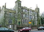
Tontine Hotel, 5 Ardgowan Square 55°57′10″N 4°46′05″W / 55.952645°N 4.76794°W / 55.952645; -4.76794 (Tontine Hotel, 5 Ardgowan Square ) Category A 34078 Upload another image See more images
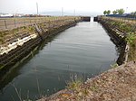
19, 20 & 21 Ardgowan Square 55°57′05″N 4°46′10″W / 55.951469°N 4.769458°W / 55.951469; -4.769458 (19, 20 & 21 Ardgowan Square ) Category C(S) 34081 30 Ardgowan Square 55°57′05″N 4°46′04″W / 55.951372°N 4.767753°W / 55.951372; -4.767753 (30 Ardgowan Square ) Category C(S) 34085 6 Brougham Street 55°57′13″N 4°45′54″W / 55.953599°N 4.765092°W / 55.953599; -4.765092 (6 Brougham Street ) Category B 34093 'Bagatelle' 47 Eldon Street 55°57′31″N 4°46′31″W / 55.958517°N 4.77541°W / 55.958517; -4.77541 ('Bagatelle' 47 Eldon Street ) Category B 34103 16 Esplanade And 68 Eldon Street 55°57′34″N 4°46′30″W / 55.959513°N 4.775096°W / 55.959513; -4.775096 (16 Esplanade And 68 Eldon Street ) Category B 34109 Scott's Dry Dock With Outer Basin 55°56′40″N 4°44′40″W / 55.944491°N 4.744309°W / 55.944491; -4.744309 (Scott's Dry Dock With Outer Basin ) Category A 50131 Upload another image
Eldon Street, Former Torpedo Works At Fort Matilda Industrial Estate 55°57′41″N 4°47′45″W / 55.961507°N 4.795799°W / 55.961507; -4.795799 (Eldon Street, Former Torpedo Works At Fort Matilda Industrial Estate ) Category B 50579 Former St. Columba's Gaelic Church, Grey Place And Patrick Street 55°57′12″N 4°45′51″W / 55.953322°N 4.764191°W / 55.953322; -4.764191 (Former St. Columba's Gaelic Church, Grey Place And Patrick Street ) Category B 34121 29 Union Street 55°57′12″N 4°46′12″W / 55.953264°N 4.769971°W / 55.953264; -4.769971 (29 Union Street ) Category C(S) 34151 38, 40 Union Street 55°57′14″N 4°46′12″W / 55.95381°N 4.77009°W / 55.95381; -4.77009 (38, 40 Union Street ) Category C(S) 34160 Fort Matilda Railway Station 55°57′33″N 4°47′43″W / 55.959031°N 4.795219°W / 55.959031; -4.795219 (Fort Matilda Railway Station ) Category B 34174 Upload another image See more images
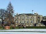
16 Ardgowan Square And 11 Robertson Street 55°57′06″N 4°46′12″W / 55.951728°N 4.769909°W / 55.951728; -4.769909 (16 Ardgowan Square And 11 Robertson Street ) Category B 34080 5, 7 Bank Street, Former Premises Of Renfrewshire Bank 55°56′46″N 4°45′25″W / 55.94622°N 4.757021°W / 55.94622; -4.757021 (5, 7 Bank Street, Former Premises Of Renfrewshire Bank ) Category B 34090 Greenock Crematorium, 1 South Street, Summerhouse Tempietto (Formerly Of Caddle Hill House Now To North Of Greenock Crematorium) 55°56′55″N 4°46′37″W / 55.948602°N 4.777006°W / 55.948602; -4.777006 (Greenock Crematorium, 1 South Street, Summerhouse Tempietto (Formerly Of Caddle Hill House Now To North Of Greenock Crematorium) ) Category B 34120 Bellevue, 8 Johnston Street 55°57′29″N 4°46′27″W / 55.958152°N 4.774053°W / 55.958152; -4.774053 (Bellevue, 8 Johnston Street ) Category B 34125 21 Madeira Street 55°57′28″N 4°46′41″W / 55.957684°N 4.778058°W / 55.957684; -4.778058 (21 Madeira Street ) Category B 34128 31 Margaret Street 55°57′20″N 4°46′19″W / 55.955662°N 4.772081°W / 55.955662; -4.772081 (31 Margaret Street ) Category B 34130 14 Union Street 55°57′05″N 4°45′57″W / 55.951404°N 4.765929°W / 55.951404; -4.765929 (14 Union Street ) Category C(S) 34155 16 Union Street 55°57′06″N 4°45′59″W / 55.951567°N 4.766277°W / 55.951567; -4.766277 (16 Union Street ) Category C(S) 34156 St Patrick's Rc Church And Presbytery, Orangefield And Holmscroft Street 55°56′48″N 4°46′12″W / 55.946622°N 4.769961°W / 55.946622; -4.769961 (St Patrick's Rc Church And Presbytery, Orangefield And Holmscroft Street ) Category A 34173 Ardgowan Estate Office, Mansion House, Ardgowan Square 55°57′08″N 4°46′02″W / 55.952124°N 4.767118°W / 55.952124; -4.767118 (Ardgowan Estate Office, Mansion House, Ardgowan Square ) Category B 34075 32 Ardgowan Square 55°57′06″N 4°46′02″W / 55.951682°N 4.767182°W / 55.951682; -4.767182 (32 Ardgowan Square ) Category C(S) 34087 84 Eldon Street And Madeira Lodge, 4 Madeira Street 55°57′35″N 4°46′37″W / 55.959724°N 4.776906°W / 55.959724; -4.776906 (84 Eldon Street And Madeira Lodge, 4 Madeira Street ) Category C(S) 34107 Inverkip Street Burial Ground 55°56′50″N 4°45′56″W / 55.947167°N 4.765691°W / 55.947167; -4.765691 (Inverkip Street Burial Ground ) Category C(S) 34123 Upload another image See more images
98,100 Newark Street 55°57′36″N 4°47′10″W / 55.959903°N 4.786085°W / 55.959903; -4.786085 (98,100 Newark Street ) Category B 34141 3 Shaw Place 55°56′47″N 4°45′28″W / 55.946311°N 4.757765°W / 55.946311; -4.757765 (3 Shaw Place ) Category B 34145 4 Shaw Place 55°56′47″N 4°45′29″W / 55.946343°N 4.757959°W / 55.946343; -4.757959 (4 Shaw Place ) Category B 34146 Watt Library And Mclean Museum Union Street, Kelly Street And Watt Street 55°57′03″N 4°45′58″W / 55.950888°N 4.766116°W / 55.950888; -4.766116 (Watt Library And Mclean Museum Union Street, Kelly Street And Watt Street ) Category A 34148 Upload another image See more images
12 Union Street 55°57′05″N 4°45′57″W / 55.951309°N 4.765778°W / 55.951309; -4.765778 (12 Union Street ) Category C(S) 34154 Kilmalcolm Road, St Laurence's Rc Church And Presbytery 55°56′23″N 4°44′48″W / 55.939738°N 4.746615°W / 55.939738; -4.746615 (Kilmalcolm Road, St Laurence's Rc Church And Presbytery ) Category A 34184 26, 27 And 28 Ardgowan Square 55°57′04″N 4°46′05″W / 55.951167°N 4.768075°W / 55.951167; -4.768075 (26, 27 And 28 Ardgowan Square ) Category B 34083 34 Esplanade And 134 Eldon Street 55°57′40″N 4°46′50″W / 55.96099°N 4.780522°W / 55.96099; -4.780522 (34 Esplanade And 134 Eldon Street ) Category B 34110 5 George Square 55°57′03″N 4°45′50″W / 55.950746°N 4.764008°W / 55.950746; -4.764008 (5 George Square ) Category C(S) 34114 St. George's North Church Of Scotland, George Square 55°57′00″N 4°45′50″W / 55.950074°N 4.763944°W / 55.950074; -4.763944 (St. George's North Church Of Scotland, George Square ) Category B 34117 12 Newark Street 55°57′27″N 4°46′37″W / 55.957496°N 4.776843°W / 55.957496; -4.776843 (12 Newark Street ) Category B 34137 Finnart - St Paul's Church Newark Street 55°57′31″N 4°46′53″W / 55.958614°N 4.781457°W / 55.958614; -4.781457 (Finnart - St Paul's Church Newark Street ) Category A 34139 21 Union Street 55°57′10″N 4°46′09″W / 55.952763°N 4.769086°W / 55.952763; -4.769086 (21 Union Street ) Category C(S) 34149 27 Union Street 55°57′11″N 4°46′11″W / 55.953126°N 4.769737°W / 55.953126; -4.769737 (27 Union Street ) Category C(S) 34150 St. John The Evangelist's Episcopal Church , Union Street 55°57′04″N 4°45′55″W / 55.951122°N 4.765316°W / 55.951122; -4.765316 (St. John The Evangelist's Episcopal Church, Union Street ) Category B 34153 22 Union Street/23 Patrick Street 55°57′07″N 4°46′00″W / 55.951871°N 4.766779°W / 55.951871; -4.766779 (22 Union Street/23 Patrick Street ) Category C(S) 34158 Convent, Little Sisters Of The Poor, Union Street (Western Block Only) 55°57′17″N 4°46′13″W / 55.954599°N 4.770178°W / 55.954599; -4.770178 (Convent, Little Sisters Of The Poor, Union Street (Western Block Only) ) Category B 34161 62 Union Street/32 Margaret Street 55°57′20″N 4°46′24″W / 55.955617°N 4.773279°W / 55.955617; -4.773279 (62 Union Street/32 Margaret Street ) Category B 34162 Well Park: Well 55°56′46″N 4°45′16″W / 55.946008°N 4.754459°W / 55.946008; -4.754459 (Well Park: Well ) Category A 34166 Upload another image See more images
Warehouse (Clyde Port Authority) East Hamilton Street, Cartsdyke 55°56′33″N 4°43′35″W / 55.942579°N 4.726363°W / 55.942579; -4.726363 (Warehouse (Clyde Port Authority) East Hamilton Street, Cartsdyke ) Category A 34172 Upload another image See more images
Bearhope/Roxburgh Street, Mcewing Building Contractors 55°56′46″N 4°45′50″W / 55.94621°N 4.763892°W / 55.94621; -4.763892 (Bearhope/Roxburgh Street, Mcewing Building Contractors ) Category B 34177 29 Ardgowan Square 55°57′05″N 4°46′05″W / 55.95127°N 4.767922°W / 55.95127; -4.767922 (29 Ardgowan Square ) Category C(S) 34084 6 Cathcart Square, Cathcart House (Formerly The Carrick Building) 55°56′51″N 4°45′21″W / 55.947521°N 4.755912°W / 55.947521; -4.755912 (6 Cathcart Square, Cathcart House (Formerly The Carrick Building) ) Category B 34099 6 George Square 55°57′02″N 4°45′51″W / 55.950652°N 4.764225°W / 55.950652; -4.764225 (6 George Square ) Category C(S) 34115