List
| Name | Location | Date Listed | Grid Ref. [note 1] | Geo-coordinates | Notes | LB Number [note 2] | Image |
|---|---|---|---|---|---|---|---|
| Cleddans Former Stables | 55°54′32″N4°00′48″W / 55.908797°N 4.013214°W | Category B | 14208 |  | |||
| Glenboig, Glenboig Farm Road, Glenboig Farmhouse | 55°54′01″N4°02′16″W / 55.900285°N 4.037903°W | Category B | 19250 | | |||
| Parish Church | 55°53′12″N3°59′44″W / 55.886768°N 3.995683°W | Category B | 19676 | 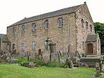 | |||
| Millcroft Former Cornmill | 55°55′27″N3°59′56″W / 55.924201°N 3.998872°W | Category B | 18438 | | |||
| Rochsoles | 55°53′13″N3°59′21″W / 55.886827°N 3.989258°W | Category B | 14205 | | |||
| Glenvmavis, Yetts Hole Road, Braidenhill Farmhouse | 55°52′54″N4°00′49″W / 55.881796°N 4.013495°W | Category B | 19251 | | |||
| Watch House And Churchyard | 55°53′12″N3°59′42″W / 55.88669°N 3.99496°W | Category B | 14204 | 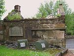 | |||
| Auchingray | 55°53′17″N3°50′45″W / 55.888057°N 3.845758°W | Category C(S) | 14206 | | |||
| Cleddans House And Garden Terrace Steps To South | 55°54′30″N4°00′47″W / 55.908287°N 4.013076°W | Category B | 14207 | |