A list of locks on the Grand Union Canal and its branches.
The Grand Union Canal (Main Line) runs from Salford Junction, Birmingham to Brentford, London. Locks have a beam of 14 feet except locks 52 to 64 in Birmingham. [1] [2] [3] [4] [5] The numbering of locks originates at Braunston, and increases both towards the north, to Lock 64, and the south, to Lock 101.
Lock number | Lock name | Rise or fall of lock(s) (heading south) | Co-ordinates | Notes |
---|---|---|---|---|
Salford Junction to Napton | ||||
64 | Nechells Shallow Lock or Salford Shallow Lock | – | 52°30'21.4"N 1°51'30.5"W | 7’ beam, gates removed |
59 – 63 | Garrison Locks or Saltley Locks | +34’ 5” | 52°29'08.6"N 1°51'47.7"W | 7’ beam |
58 | Stop lock Digbeth branch | – | Abolished | |
52 – 57 | Camp Hill Locks | +41’ 8” | 52°28'20.9"N 1°52'34.7"W | 7’ beam |
47 – 51 | Knowle Locks | –41’ 10” | 52°22'57.8"N 1°43'20.2"W | |
46 | Hatton Top Lock | -146’ 6” | 52°17'57.2"N 1°39'02.5"W | |
27 – 45 | Hatton Locks | 52°17'58.5"N 1°38'41.4"W | ||
26 | Hatton Bottom Lock | 52°17'13.6"N 1°36'39.2"W | ||
24 – 25 | Cape Locks | −14’ 4” | 52°17'33.2"N 1°35'41.6"W | |
23 | Radford Bottom Lock | +7’ 0” | 52°16'53.6"N 1°29'07.0"W | |
20 – 22 | Fosse Locks | +21’ 0” | 52°16'35.9"N 1°28'07.2"W | |
19 | Wood Lock | +6’ 7” | 52°16'18.4"N 1°26'57.3"W | |
18 | Welsh Road Lock | +6’ 11” | 52°16'21.6"N 1°26'09.8"W | |
14 – 17 | Bascote Locks | +26’ 9” | 52°16'26.7"N 1°25'17.1"W | Locks 14 & 15 are a staircase lock |
13 | Itchington Bottom Lock | +6’ 7” | 52°16'43.9"N 1°23'10.6"W | |
5 – 12 | Stockton Locks | +54’ 7” | 52°16'49.2"N 1°22'08.6"W | |
4 | Stockton Top Lock | 52°16'53.7"N 1°21'54.5"W | ||
1 – 3 | Calcut Locks | +16’ 2” | 52°16'05.3"N 1°18'57.9"W | |
Napton to Braunton – Oxford Canal (no locks) | ||||
Braunston to Brentford | ||||
1 | Braunston Bottom Lock | +35’ 6” | 52°17'20.8"N 1°12'09.9"W | |
2 – 5 | Braunston Lock Flight | 52°17'14.0"N 1°11'40.6"W | ||
6 | Braunston Top Lock | 52°17'10.4"N 1°11'28.4"W | ||
7 | Buckby Top Lock | -63’ 0” | 52°17'08.4"N 1°06'49.5"W | |
8 – 12 | Buckby Lock Flight | 52°16'44.9"N 1°05'52.5"W | ||
13 | Buckby Bottom Lock | 52°16'24.8"N 1°05'43.0"W | ||
14 – 15 | Stoke Bruerne Locks | -16’ 0” | 52°08'31.3"N 0°54'53.3"W | |
16 – 20 | Stoke Bruerne Locks | -40’ 0” | 52°08'11.8"N 0°54'30.0"W | |
21 | Cosgrove Lock | -3’ 4” | 52°04'22.8"N 0°50'29.7"W | |
22 | Fenny Stratford Lock | +1’ 1” | 52°00'02.7"N 0°42'51.6"W | |
23 | Stoke Hammond Lock | +6’ 11” | 51°57'40.8"N 0°42'39.3"W | |
24 – 26 | Soulbury Three Locks | +20’ 3” | 51°56'49.0"N 0°42'16.2"W | |
27 | Leighton Lock | +6’ 8” | 51°55'36.8"N 0°39'54.1"W | |
28 | Grove Lock | +7’ 6” | 51°53'53.5"N 0°40'17.0"W | |
29 | Church Lock | +6’ 9” | 51°53'35.6"N 0°39'44.9"W | |
30 | Slapton Lock | +7’ 1” | 51°52'23.8"N 0°39'08.0"W | |
31 | Horton Lock | +6’ 9” | 51°52'00.1"N 0°38'55.1"W | |
32 – 33 | Ivinghoe Locks | +14’ 3” | 51°51'26.7"N 0°38'48.0"W | |
34 – 36 | Seabrook Locks | +20’ 4” | 51°50'45.6"N 0°38'38.5"W | |
37 – 38 | Marsworth Locks | +14’ 4” | 51°49'42.2"N 0°39'39.1"W | |
39 – 45 | Marsworth Locks | +42’ 3” | 51°48'57.2"N 0°39'15.3"W | Bulbourne, summit, 473 feet (144 metres) above Thames Locks. |
46 | Cowroast Lock | -6’ 0” | 51°47'01.0"N 0°36'44.3"W | |
47 – 48 | Dudswell Locks | -13’ 4” | 51°46'46.6"N 0°36'18.1"W | |
49 | Northchurch Lock | -26’ 11” | 51°46'16.6"N 0°35'19.0"W | Northchurch Locks |
50 | Bushes Lock | 51°46'03.6"N 0°34'56.2"W | ||
51 | Gas 1 Lock | 51°45'55.4"N 0°34'23.5"W | ||
52 | Gas 2 Lock | 51°45'53.4"N 0°34'17.8"W | ||
53 | Berkhamsted Lock | -16’ 10” | 51°45'44.6"N 0°33'50.5"W | Berkhamsted Locks |
54 | Ravens Lock | 51°45'37.2"N 0°33'26.1"W | ||
55 | Rising Sun Lock | 51°45'33.0"N 0°33'22.6"W | ||
56 | Top Side Lock | -19’ 4” | 51°45'18.4"N 0°32'40.7"W | Bourne End Locks |
57 | Bottom Side Lock | 51°45'09.0"N 0°32'22.8"W | ||
58 | Sewer Lock | 51°45'03.2"N 0°32'03.7"W | ||
59 | Bourne End Bottom Lock | -7’ 4” | 51°44'50.6"N 0°31'24.5"W | |
60 | Winkwell Lock | -13’ 7” | 51°44'50.6"N 0°31'24.6"W | |
61 | Winkwell Bottom Lock | 51°44'47.1"N 0°30'44.6"W | ||
62 | Boxmoor Top Lock | -6’ 8” | 51°44'42.1"N 0°30'02.7"W | |
63 | Fishery Lock | -7’ 1” | 1°44'39.1"N 0°29'29.6"W | |
64 | Boxmoor Lock | -7’ 1” | 51°44'35.2"N 0°28'34.1"W | |
65 – 67 | Apsley Locks | -16’ 0” | 51°44'10.7"N 0°27'49.5"W | |
68 | Nash Mills Lock | -12’ 2” | 51°43'46.9"N 0°27'13.7"W | Nash Mills Locks |
69 | Red Lion Lock | 51°43'40.1"N 0°27'09.4"W | ||
69A | Kings Langley Lock | -8’ 9” | 51°42'50.5"N 0°26'40.0"W | |
70 | Home Park Lock | -5’ 2” | 51°42'25.2"N 0°26'31.0"W | |
71 | North Grove Lock | -6' 11" | 51°41'58.2"N 0°26'19.9"W | |
72 – 73 | Hunton Bridge Locks | -11’ 2” | 51°41'26.1"N 0°26'05.6"W | |
74 | Lady Capel's Lock | -5’ 4” | 51°40'52.7"N 0°25'53.6"W | |
75 – 76 | Cassiobury Park Locks | -10’ 0” | 51°40'19.6"N 0°25'35.1"W | |
77 | Iron Bridge Lock | -9’ 4” | 51°39'51.7"N 0°25'36.6"W | |
78 | Cassio Bridge Lock | -9’ 0” | 51°39'16.2"N 0°25'39.5"W | |
79 | Common Moor Lock | -9’ 5” | 51°38'43.1"N 0°26'19.2"W | |
80 | Lot Mead Lock | -6’ 3” | 51°38'17.0"N 0°27'03.4"W | |
81 | Batchworth Lock | -6’ 8” | 51°38'05.7"N 0°27'58.8"W | |
82 | Stocker's Lock | -5’ 2” | 51°37'48.3"N 0°28'52.4"W | |
83 | Springwell Lock | -7’ 11” | 51°37'32.0"N 0°29'40.9"W | |
84 | Copper Mill Lock | -5’ 10” | 51°36'38.9"N 0°29'54.3"W | |
85 | Black Jack's Lock | -3’ 8” | 51°36'09.0"N 0°29'43.2"W | |
86 | Widewater Lock | -8’ 0” | 51°35'15.4"N 0°29'09.8"W | |
87 | Denham Deep Lock | -11’ 1” | 51°33'55.1"N 0°28'56.0"W | |
88 | Uxbridge Lock | -4’ 7” | 51°33'08.6"N 0°29'00.7"W | |
89 | Cowley Lock | -6’ 6” | 51°31'44.1"N 0°29'08.4"W | |
90 | Norwood Top Lock | -7’ 10” | 51°30'06.6"N 0°21'47.4"W | |
91 – 97 | Hanwell Locks | -53’ 2” | 51°30'19.5"N 0°20'50.5"W | |
98 | Osterley Lock | -5’ 7” | 51°29'48.6"N 0°19'57.6"W | |
99 | Clitheroe's Lock | -7’ 7” | 51°29'20.3"N 0°19'17.3"W | |
100 | Brentford Gauging Locks | -5’ 6” | 51°28'59.3"N 0°18'41.7"W | |
101 | Thames Locks | Tidal | 51°28'55.8"N 0°18'17.3"W | Into tidal River Thames |
The Paddington Arm and the Slough Arm have no locks.
The Wendover Arm Canal has one stop lock.
The Aylesbury Arm has 16 locks, see Aylesbury Canal Society.
The Leicester Branch from Norton Junction to the River Trent has 59 locks, see table. [2] [5]
The Welford Arm, off the Leicester Branch, has one lock, Welford Lock with a rise of 3’ 6”. [2]
The Northampton Arm from Gayton Junction to the River Nene has 17 locks, see table. [1] [5]
Lock number | Lock name | Rise or fall of lock(s) (heading north) | Co-ordinates | Notes |
---|---|---|---|---|
1 | Watford Bottom Lock | +52’ 6” | 52°11'52.7"N 0°56'39.6"W | |
2 – 7 | Watford Locks | 52°18'49.7"N 1°07'54.8"W | 3 – 6 are staircase locks | |
8 – 17 | Foxton Locks | -75’ 0” | 52°30'00.9"N 0°58'58.5"W | Two staircases of five locks each. |
18 | Kibworth Top Lock | -7’ 7” | 52°32'37.9"N 1°01'54.5"W | |
19 | Kibworth Second (or Gas Pipe) Lock | -7’ 2” | 52°32'45.7"N 1°01'36.9"W | |
20 | Taylor's Turnover Lock | -5’ 5” | 52°32'49.4"N 1°01'32.2"W | |
21 | Pywell's Lock | -7’ 5” | 52°32'55.5"N 1°01'31.2"W | |
22 | Crane's Lock | -5’ 9” | 52°33'13.1"N 1°01'52.4"W | |
23 | Newton Top Lock | -5’ 6” | 52°33'53.0"N 1°03'40.8"W | |
24 | Spinney Lock | -6’ 9” | 52°33'51.6"N 1°03'57.4"W | |
25 | Top Half Mile Lock | -7’ 2” | 52°33'49.1"N 1°04'12.3"W | |
26 | Bottom Half Mile Lock | -6’ 9” | 52°33'32.7"N 1°04'46.3"W | |
27 | Turnover Lock | -7’ 5” | 52°33'33.5"N 1°04'51.9"W | |
28 | Tythorne Lock | -6’ 9” | 52°33'36.4"N 1°05'10.7"W | |
29 | Bumblebee Lock | -6’ 2” | 52°33'43.2"N 1°05'21.1"W | |
30 | Kilby Lock | -6’ 4” | 52°34'05.5"N 1°06'36.5"W | |
31 | Double Rail Lock | -7’ 9” | 52°34'05.2"N 1°07'04.6"W | |
32 | Ervin's Lock | -7’ 0” | 52°34'26.6"N 1°07'27.5"W | |
33 | Bush Lock | -7’ 7” | 52°34'34.7"N 1°08'24.1"W | |
34 | Dunn's Lock | -6’ 4” | 52°34'52.5"N 1°09'26.6"W | |
35 | Whetstone Lane Lock | -6’ 4” | 52°34'56.9"N 1°10'01.2"W | |
36 | Gee's Lock | -7’ 2” | 52°35'11.1"N 1°10'40.5"W | |
37 | Blue Banks Lock | -7’ 2” | 52°35'26.4"N 1°10'18.0"W | |
38 | Kings Lock | -7’ 9” | 52°36'05.9"N 1°09'51.3"W | |
39 | Aylestone Mill Lock | -6’ 5” | 52°36'34.9"N 1°08'51.8"W | |
40 | St Mary's Mill Lock | -3’ 6” | 52°37'03.6"N 1°08'54.3"W | |
41 | Freeman's Meadow Lock | -6’ 5” | 52°37'17.2"N 1°08'41.4"W | |
42 | North Lock | -4’ 7” | 52°38'27.5"N 1°08'35.5"W | |
43 | Limekiln Lock | -4’ 3” | 52°38'43.7"N 1°07'46.3"W | |
44 | Belgrave Lock | -3’ 11” | 52°39'15.0"N 1°07'41.7"W | Joins River Soar |
45 | Birstall Lock | -3’ 4” | 52°40'25.2"N 1°06'57.1"W | |
46 | Thurmaston Lock | -3’ 2” | 52°40'45.1"N 1°06'05.8"W | Leaves River Soar |
47 | Junction Lock | -4’ 9” | 52°42'24.6"N 1°06'30.7"W | |
48 | Cossington Lock | -5’ 3” | 52°42'37.2"N 1°07'15.4"W | Joins River Soar |
49 | Sileby Lock | -4’ 6” | 52°43'37.2"N 1°07'25.6"W | |
50 | Mountsorrel Lock | -4’ 1” | 52°43'54.4"N 1°08'22.5"W | |
51 | Barrow Deep Lock | -9’ 7” | 52°44'59.1"N 1°09'08.5"W | |
52 | Pilling's Flood Lock | 52°45'30.7"N 1°09'50.2"W | ||
53 | Loughborough Lock | -6’ 9” | 52°46'49.1"N 1°12'58.5"W | |
54 | Bishop Meadow Lock | -8’ 7” | 52°47'22.6"N 1°13'00.5"W | |
55 | Zouch Lock | -6’ 4” | 52°48'23.4"N 1°15'22.6"W | |
56 | Kegworth Deep Lock | -7’ 9” | 52°50'11.5"N 1°16'16.1"W | |
57 | Kegworth Shallow (flood) Lock | 52°50'26.2"N 1°16'03.7"W | ||
58 | Ratcliffe Lock | -6’ 8” | 52°51'31.1"N 1°16'18.7"W | |
59 | Redhill Lock (flood lock) | 52°52'05.7"N 1°16'12.9"W | River Trent |
The lock numbering sequence of the Leicester Branch continues along the Erewash Canal. From Lock 60 Trent Lock north to Lock 74 at Eastwood.
From Gayton Junction the Northampton Arm descends to the River Nene. [6]
Lock number | Lock name | Fall of lock (heading to River Nene) | Co-ordinates | Notes |
---|---|---|---|---|
1 | Rothersthorpe Top Lock | -79' 10" | 52°11'52.7"N 0°56'39.6"W | |
2 – 12 | Rothersthorpe Locks | 52°12'13.6"N 0°56'21.6"W | ||
13 | Rothersthorpe Bottom Lock | 52°12'37.0"N 0°56'18.5"W | ||
14 | Wootton Lock | -6' 9" | 52°12'59.5"N 0°56'28.1"W | |
15 | Hardingstone Lock | -6' 3" | 52°13'33.2"N 0°55'59.5"W | |
16 | Huinsbury Lock | -6' 10" | 52°13'43.6"N 0°54'48.2"W | |
17 | Northampton Lock | -5' 0" | 52°13'48.6"N 0°53'57.2"W | River Nene |
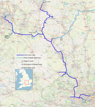
The Grand Union Canal in England is part of the British canal system. It is the principal navigable waterway between London and the Midlands. Starting in London, one arm runs to Leicester and another ends in Birmingham, with the latter stretching for 137 miles (220 km) with 166 locks from London. The Birmingham line has a number of short branches to places including Slough, Aylesbury, Wendover, and Northampton. The Leicester line has two short arms of its own, to Market Harborough and Welford.
The Birmingham and Fazeley Canal is a canal of the Birmingham Canal Navigations in the West Midlands of England. Its purpose was to provide a link between the Coventry Canal and Birmingham and thereby connect Birmingham to London via the Oxford Canal.
The Trent and Mersey Canal is a 93+1⁄2-mile (150 km) canal in Derbyshire, Staffordshire and Cheshire in north-central England. It is a "narrow canal" for the vast majority of its length, but at the extremities to the east of Burton upon Trent and north of Middlewich, it is a wide canal.
The Staffordshire and Worcestershire Canal is a navigable narrow canal in Staffordshire and Worcestershire in the English Midlands. It is 46 miles (74 km) long, linking the River Severn at Stourport in Worcestershire with the Trent and Mersey Canal at Haywood Junction by Great Haywood.
The Shropshire Union Canal, nicknamed the "Shroppie", is a navigable canal in England. The Llangollen and Montgomery canals are the modern names of branches of the Shropshire Union (SU) system and lie partially in Wales.
The Grand Junction Canal is a canal in England from Braunston in Northamptonshire to the River Thames at Brentford, with a number of branches. The mainline was built between 1793 and 1805, to improve the route from the Midlands to London, by-passing the upper reaches of the River Thames near Oxford, thus shortening the journey.
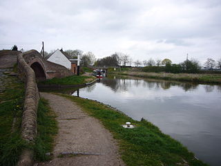
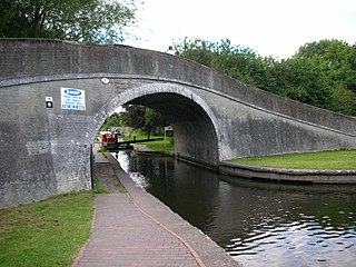
Whilton Locks is the name of a flight of seven locks on the Grand Union Canal near Daventry, in the county of Northamptonshire, England. They are also referred to as Buckby Lock Flight.
The Grand Union Canal was a canal in England from Foxton, Leicestershire on the Leicestershire and Northamptonshire Union Canal to Norton Junction, close to Long Buckby Wharf on the Grand Junction Canal. It now forms the first 23 miles (37 km) of the Leicester line of the Grand Union Canal.
Haywood Junction, or Great Haywood Junction, is the name of the canal junction where the Staffordshire and Worcestershire Canal terminates and meets the Trent and Mersey Canal near to the village of Great Haywood, Staffordshire, England.
Autherley Junction is the name of the canal junction where the Shropshire Union Canal terminates and meets the Staffordshire and Worcestershire Canal near to Oxley, north Wolverhampton, West Midlands, England.
Aldersley Junction is the name of the canal junction where the Birmingham Main Line Canal terminates and meets the Staffordshire and Worcestershire Canal near to Oxley, north Wolverhampton, West Midlands, England. It opened in 1772.
Fazeley Junction is the name of the canal junction where the authorised Birmingham and Fazeley Canal terminates and meets the Coventry Canal at Fazeley, near Tamworth, Staffordshire, England.
Aston Junction is the name of the canal junction where the Digbeth Branch Canal terminates and meets the Birmingham and Fazeley Canal near to Aston, Birmingham, England.
Bordesley Junction is a canal junction where the Grand Union Canal splits near to Bordesley, Birmingham, England. It opened in 1844, when the Birmingham and Warwick Junction Canal was built as part of a scheme to bypass the congestion at the Farmers Bridge flight of locks.
The Four Counties Ring is a canal ring which links the four English counties of Cheshire, Staffordshire, Shropshire and West Midlands.
Horseley Fields Junction is a canal junction at the western limit of the Wyrley and Essington Canal where it meets the BCN Main Line, at Horseley Fields east of Wolverhampton, in the West Midlands, England.
Huddlesford Junction is a canal junction at the original north-eastern limit of the Wyrley and Essington Canal where it met the Coventry Canal, near Lichfield, in Staffordshire, England.
Kingswood Junction is a canal junction where the Stratford-upon-Avon Canal meets the Grand Union Canal at Kingswood, Warwickshire, England.
Delph Locks or the Delph Nine are a series of eight narrow canal locks on the Dudley No. 1 Canal in Brierley Hill, in the West Midlands, England. They were opened in 1779, and reopened in 1967 following restoration of the Dudley Canal and the Stourbridge Canal in a joint venture between the Staffordshire and Worcestershire Canal Society and the British Waterways Board.
The Aylesbury Canal Society is a waterway society on the Grand Union Canal, Buckinghamshire, England. The society was launched in 1971 to promote the use of the Aylesbury Arm, and to run moorings leased from British Waterways.