Related Research Articles

Nigeria, officially the Federal Republic of Nigeria, is a country in West Africa. It is situated between the Sahel to the north and the Gulf of Guinea to the south in the Atlantic Ocean. It covers an area of 923,769 square kilometres (356,669 sq mi), and with a population of over 230 million, it is the most populous country in Africa, and the world's sixth-most populous country. Nigeria borders Niger in the north, Chad in the northeast, Cameroon in the east, and Benin in the west. Nigeria is a federal republic comprising 36 states and the Federal Capital Territory, where the capital, Abuja, is located. The largest city in Nigeria is Lagos, one of the largest metropolitan areas in the world and the largest in Africa.

Kogi State is a state in the North Central region of Nigeria, bordered to the west by the states of Ekiti and Kwara, to the north by the Federal Capital Territory, to the northeast by Nasarawa State, to the northwest by Niger State, to the southwest by the Edo and Ondo states, to the southeast by the states of Anambra and Enugu, and to the east by Benue State. It is the only state in Nigeria to border ten other states. Named for the Hausa word for river (Kogi). Kogi State was formed from parts of Benue State, Niger State, and Kwara State on 27 August 1991. The state is nicknamed the "Confluence State" due to the fact that the confluence of the River Niger and the River Benue occurs next to its capital, Lokoja.
Akwa Ibom State is a state in the South-South geopolitical zone of Nigeriaon the east by Cross River State, on the west by Rivers State and Abia State, and on the south by the Atlantic Ocean. The state takes its name from the Qua Iboe River which bisects the state before flowing into the Bight of Bonny. Akwa Ibom was split from Cross River State in 1987 with its capital Uyo and with 31 local government areas.

Port Harcourt is the capital and largest city in Rivers State, Nigeria. It is the fifth most populous city in Nigeria after Lagos, Kano, Ibadan and Benin. It lies along the Bonny River and is located in the Niger Delta. As of 2023, Port Harcourt's urban population is estimated at 3.5m. The population of the metropolitan area of Port Harcourt is almost twice its urban area population with a 2015 United Nations estimate of 2,344,000. In 1950, the population of Port Harcourt was 59,752. Port Harcourt has grown by 150,844 since 2015, which represents a 4.99% annual change. Historically it has been known as "Ígwúóchán" in the Ikwerre language, also Obomuotu Country within which a few other smaller areas were called Diobu.
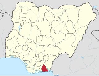
Delta State is a state in the South-South geopolitical zone of Nigeria. Named after the Niger Delta—a large part of which is in the state—the state was formed from the former Bendel State on August 27, 1991. Bordered on the north by Edo State, the east by Anambra and Rivers States, and the south by Bayelsa State across the Niger River for 17 km and the Forç

Abia State is a state in the South-East geopolitical zone of Nigeria, it is bordered to the north and northeast by the states of Enugu, and Ebonyi, Imo State to the west, Cross River State to the east, Akwa Ibom State to the southeast, and Rivers State to the south. It takes its name from the acronym for four of the state's most populated regions: Aba, Bende, Isuikwuato, and Afikpo. The state capital is Umuahia while the largest city and commercial centre is Aba.

Cross River State is a state in the South-South geopolitical zone of Nigeria. Named for the Cross River, the state was formed from the eastern part of the Eastern Region on 27 May 1967. Its capital is Calabar, it borders to the north through Benue state, to the west through Ebonyi state and Abia state, and to the southwest through Akwa Ibom state, while its eastern border forms part of the national border with Cameroon. Originally known as the South-Eastern State before being renamed in 1976, Cross River state formerly included the area that is now Akwa Ibom state, which became a distinct state in 1987.

Calabar is the capital city of Cross River State, Nigeria. It was originally named Akwa Akpa, in the Efik language. The city is adjacent to the Calabar and Great Kwa rivers and creeks of the Cross River.

Benue State is one of the North Central states in Nigeria with a population of about 4,253,641 in 2006 census. The state was created in 1976 among the seven states created at that time. The state derives its name from the Benue River which is the second largest river in Nigeria after the River Niger. The state borders Nasarawa State to the North; Taraba State to the East; Kogi State to the West; Enugu State to the South-West; Ebonyi and Cross-Rivers States to the South; and has an international border with Cameroon to the South-East. It is inhabited predominantly by the Tiv, Idoma and Igede. Minority ethnic groups in Benue are Etulo, Igbo, Jukun peoples etc. Its capital is Makurdi. Benue is a rich agricultural region; popularly grown crops include: oranges, mangoes, sweet potatoes, cassava, soya bean, guinea corn, flax, yams, sesame, rice, groundnuts, and Palm Tree.
The Niger Delta is the delta of the Niger River sitting directly on the Gulf of Guinea on the Atlantic Ocean in Nigeria. It is located within nine coastal southern Nigerian states, which include: all six states from the South South geopolitical zone, one state (Ondo) from South West geopolitical zone and two states from South East geopolitical zone.

Rivers State, also known as Rivers, is a state in the Niger Delta region of southern Nigeria. Formed in 1967, when it was split from the former Eastern Region, Rivers State borders include: Imo to the north, Abia and Akwa Ibom to the east, and Bayelsa and Delta to the west. The State capital, Port Harcourt, is a metropolis that is considered to be the commercial center of the Nigerian oil industry.
Taraba is a state in North Eastern Nigeria, named after the Taraba River, which traverses the southern part of the state. Taraba state's capital is Jalingo. The main ethnic groups are the Fulani, Tiv, Mumuye, Mambilla, Wurkuns, Jukun, Kuteb, Yandang, Ndola, Itchen, Tigun and Jibu. The northern parts is mainly dominated by Fulani of Muri emirate. The southern parts are dominated by the Jukun, Chamba, Tiv, Kuteb and Ichen.The central region is mainly occupied by the Fulani, Mambilla and the Jibu peoples. There are over 77 different tribes, and their languages in Taraba State.
Asaba is the capital city of Delta State, Nigeria. It is located at the western bank of the Niger River, in the Oshimili South Local Government Area. Asaba had a population of 149,603 as at the 2006 census, and a metropolitan population of over half a million people.
Bayelsa is a state in the South South region of Nigeria, located in the core of the Niger Delta. Bayelsa State was created in 1996 and was carved out from Rivers State, making it one of the newest states in the federation. The capital, Yenagoa, is susceptible to high risk of annual flooding. It shares a boundary with Rivers State to the east and Delta State to the north across the Niger River for 17 km and the Forçados River for 198 km, with the waters of the Atlantic Ocean dominating its southern borders. It has a total area of 10,773 square kilometres (4,159 sq mi). The state comprises eight local government areas: Ekeremor, Kolokuma/Opokuma, Yenagoa, Nembe, Ogbia, Sagbama, Brass and Southern Ijaw. The state is the smallest in Nigeria by population as of the 2006 census. Being in the Niger Delta, Bayelsa State has a riverine and estuarine setting, with bodies of water within the state preventing the development of significant road infrastructure.

Enugu State is a state in the South-East geopolitical zone of Nigeria, bordered to the north by the states of Benue and Kogi, Ebonyi State to the east and southeast, Abia State to the south, and Anambra State to the west. The state takes its name from its capital and largest city, Enugu. The city acquired township status in 1917 and was called Enugwu-Ngwo. Due to the rapid expansion towards areas owned by other indigenous communities, it was renamed Enugu in 1928.

Osun State, occasionally known as the State of Osun by the state government, is a state in southwestern Nigeria; bounded to the east by Ekiti and Ondo states, to the north by Kwara State, to the south by Ogun State and to the west by Oyo State. Named for the River Osun—a vital river which flows through the state—the state was formed from the southeast of Oyo State on 27 August 1991 and has its capital as the city of Osogbo.

Rivers State University, formerly Rivers State University of Science and Technology, is a university located in the Diobu area of Port Harcourt, Rivers State, Nigeria.

The coat of arms of Nigeria consists of a black shield with a wavy white pall, symbolizing the meeting of the Niger and Benue Rivers at Lokoja. The black shield represents Nigeria's fertile soil, while the two supporting horses or chargers on each side represent dignity. The eagle represents strength, while the green and white twists of the torse on the top of the shield represent the rich soil.
Articles related to Nigeria include: