List of monuments in Gudja

Last updated

This is a list of monuments in Gudja , Malta, which are listed on the National Inventory of the Cultural Property of the Maltese Islands. [1] [2]

Contents

List

Name of objectLocationCoordinatesIDPhotoUpload
Il-Ġnien Tal-Kmand Triq Bir Miftuħ 35°51′04″N14°29′58″E / 35.851139°N 14.499306°E / 35.851139; 14.499306 01167 Gnien tal-Kmand, Gudja.jpg Missing-monuments-image.svg
Palazzo Dorell Triq Ħal-Tarxien 35°51′02″N14°30′25″E / 35.850631°N 14.507025°E / 35.850631; 14.507025 (Palazzo Dorell) 01168 Architecture in Gudja 4.jpg Missing-monuments-image.svg
Chapel of St. Marija ta' Bir Miftuh Triq Santa Marija 35°51′06″N14°29′51″E / 35.851639°N 14.497444°E / 35.851639; 14.497444 (Chapel of St. Marija ta' Bir Miftuh) 01806 Chapel of St. Marija ta' Bir Miftuh.jpg Missing-monuments-image.svg
Niche of the Madonna of SorrowsTriq Ħal-Għaxaq / Triq Ħal-Tarxien 35°56′56″N14°24′09″E / 35.9489643°N 14.4024856°E / 35.9489643; 14.4024856 (Niche of the Madonna of Sorrows) 01807 Niche of the Madonna of Sorrows, Gudja.jpg Missing-monuments-image.svg
Niche of the Madonna of Graces117-119, Triq Santa Marija 35°51′02″N14°30′04″E / 35.850527°N 14.501236°E / 35.850527; 14.501236 (Niche of the Madonna of Graces) 01808 Niche of the Madonna of Graces, Gudja.jpg Missing-monuments-image.svg
Niche of the Madonna of Lourdes40, Triq Santa Marija 35°50′58″N14°30′10″E / 35.849500°N 14.502667°E / 35.849500; 14.502667 (Niche of the Madonna of Lourdes) 01809 Niche of the Madonna of Lourdes, Gudja.jpg Missing-monuments-image.svg
Chapel of the AnnunciationTriq L-Annunzjata 35°50′57″N14°30′11″E / 35.849169°N 14.502943°E / 35.849169; 14.502943 (Chapel of the Annunciation) 01810 Walking in Gudja 13.jpg Missing-monuments-image.svg
Niche of the Madonna of the GirdleTriq L-Annunzjata / Triq Raymond Caruana 35°50′57″N14°30′14″E / 35.849181°N 14.503796°E / 35.849181; 14.503796 (Niche of the Madonna of the Girdle) 01811 Niche of the Madonna of the Girdle.jpg Missing-monuments-image.svg
Niche of the AssumptionTriq il-Kbira / Triq San Ciru 35°50′53″N14°30′10″E / 35.848193°N 14.502867°E / 35.848193; 14.502867 (Niche of the Assumption) 01812 Niche of the Assumption, Gudja.jpg Missing-monuments-image.svg
Statue of St JosephTriq il-Kbira (near St. Mary's church) 35°50′54″N14°30′10″E / 35.848319°N 14.502804°E / 35.848319; 14.502804 (Statue of St Joseph) 01813 Walking in Gudja 28.jpg Missing-monuments-image.svg
Statue of the AssumptionTriq il-Kbira (near St. Mary's church) 35°50′52″N14°30′09″E / 35.847836°N 14.502521°E / 35.847836; 14.502521 (Statue of the Assumption) 01814 Gudja 22.jpg Missing-monuments-image.svg
CrossTriq il-Kbira / Triq Ġilormu Cassar 35°50′51″N14°30′08″E / 35.847389°N 14.502270°E / 35.847389; 14.502270 (Cross) 01815 Buildings in Gudja 13.jpg Missing-monuments-image.svg
Niche of the Madonna of the RosaryTriq Ġilormu Cassar / Triq il-Kbira 35°50′50″N14°30′08″E / 35.847324°N 14.502212°E / 35.847324; 14.502212 (Niche of the Madonna of the Rosary) 01816 Niche of the Madonna of the Rosary, Gudja.jpg Missing-monuments-image.svg
Empty Niche (Madonna of Rosary)40, Triq San Mark 35°50′51″N14°30′06″E / 35.847443°N 14.501606°E / 35.847443; 14.501606 (Empty Niche (Madonna of Rosary)) 01817 Buildings in Gudja 19.jpg Missing-monuments-image.svg
Niche of the Holy Family34, Triq San Mark 35°50′52″N14°30′06″E / 35.847714°N 14.501614°E / 35.847714; 14.501614 (Niche of the Holy Family) 01818 Niche of the Holy Family, Gudja.jpg Missing-monuments-image.svg
Niche of St. Anthony28, Triq San Mark 35°50′52″N14°30′06″E / 35.847829°N 14.501610°E / 35.847829; 14.501610 (Niche of St. Anthony) 01819 Niche of St. Anthony, Gudja.jpg Missing-monuments-image.svg
Niche of the AssumptionTriq iż-Żebbuġa 35°50′53″N14°30′08″E / 35.848112°N 14.502151°E / 35.848112; 14.502151 (Niche of the Assumption) 01820 Niche of the Assumption, Gudja village.jpg Missing-monuments-image.svg
Niche of St Paul (statue removed)Triq id-Dejqa / Triq Santa Katerina 35°50′53″N14°30′12″E / 35.848112°N 14.503424°E / 35.848112; 14.503424 (Niche of St Paul (statue removed)) 01821 Niche of St Paul without statue.jpg Missing-monuments-image.svg
Niche of the Immaculate Conception30, Triq San Ciru 35°50′53″N14°30′12″E / 35.848069°N 14.503420°E / 35.848069; 14.503420 (Niche of the Immaculate Conception) 01822 Statue of the Assumption, il-Gudja.jpg Missing-monuments-image.svg
Niche of St JosephTriq San Ciru / Triq Santa Katerina 35°50′52″N14°30′12″E / 35.847663°N 14.503417°E / 35.847663; 14.503417 (Niche of St Joseph) 01823 Niche of St Joseph, Gudja.jpg Missing-monuments-image.svg
Statue of the Assumption11, Triq Santa Katerina 35°50′56″N14°30′14″E / 35.848813°N 14.503926°E / 35.848813; 14.503926 (Statue of the Assumption) 01824 Statue of the Assumption, tal-Gudja.jpg Missing-monuments-image.svg
Chapel of St. Catherine61, Triq Raymond Caruana 35°50′56″N14°30′14″E / 35.848813°N 14.503926°E / 35.848813; 14.503926 (Chapel of St. Catherine) 01825 Chapel of St. Catherine, Gudja.jpg Missing-monuments-image.svg
Niche of the Madonna of Mount Carmel35-37, Triq Raymond Caruana 35°50′59″N14°30′18″E / 35.849833°N 14.504889°E / 35.849833; 14.504889 (Niche of the Madonna of Mount Carmel) 01826 Niche of the Madonna of Mount Carmel, Gudja.jpg Missing-monuments-image.svg
Niche of Christ the King"Kristu Re", 104, Triq Raymond Caruana 35°50′56″N14°30′12″E / 35.848778°N 14.503389°E / 35.848778; 14.503389 (Niche of Christ the King) 01827 Niche of Christ the King, Gudja.jpg Missing-monuments-image.svg
Niche of the Madonna of Light115, Triq il-Kbira 35°50′46″N14°30′07″E / 35.846139°N 14.501944°E / 35.846139; 14.501944 (Niche of the Madonna of Light) 01828 Niche of the Madonna of Light.jpg Missing-monuments-image.svg
Niche of St JosephTriq il-Magħsar / Triq San Pawl 35°50′54″N14°30′02″E / 35.848278°N 14.500667°E / 35.848278; 14.500667 (Niche of St Joseph) 01829 Niche of St Joseph il-Gudja.jpg Missing-monuments-image.svg
Niche of the Madonna of LoretoTriq ta' Loreto 35°50′36″N14°30′08″E / 35.843417°N 14.502333°E / 35.843417; 14.502333 (Niche of the Madonna of Loreto) 01830 Niche of the Madonna of Loreto, Gudja.jpg Missing-monuments-image.svg
Chapel of the Madonna of LoretoTriq ta' Loreto / Triq Ħal Far 35°50′30″N14°30′02″E / 35.841667°N 14.500694°E / 35.841667; 14.500694 (Chapel of the Madonna of Loreto) 01831 Chapel of the Madonna of Loreto.jpg Missing-monuments-image.svg
Statue of the Immaculate ConceptionOn a farm near Loreto Chapel (approximate location) 35°50′35″N14°30′12″E / 35.843056°N 14.503333°E / 35.843056; 14.503333 (Statue of the Immaculate Conception) 01832 Statue of the Immaculate Conception, Gudja.jpg Missing-monuments-image.svg
Statue of St. PaulOn a farm near Loreto Chapel (approximate location) 35°50′35″N14°30′12″E / 35.843056°N 14.503333°E / 35.843056; 14.503333 (Statue of St. Paul) 01833 Statue of St. Paul, Gudja.jpg Missing-monuments-image.svg
Statue of St. PaulVjal l-Avjazzjoni (opposite the airport staff carpark) 35°50′50″N14°29′56″E / 35.847333°N 14.498972°E / 35.847333; 14.498972 (Statue of St. Paul) 01834 St Paul Farmhouse 02.jpg Missing-monuments-image.svg
Parish Church of the Assumption Triq il-Kbira 35°50′54″N14°30′08″E / 35.848250°N 14.502278°E / 35.848250; 14.502278 (Parish Church of the Assumption) 01835 Parish Church of the Assumption.jpg Missing-monuments-image.svg

Related Research Articles

Gudja Local council in Southern Region, Malta

Gudja is a village in the Southern Region of Malta, with a population of 3,148 as of March 2017. The village is located on high grounds, south of Valletta. It is administered by the Gudja Local Council. A number of schools, clubs, public gardens and recreations places are found around the village.

Fort Ricasoli Historic fort on Malta

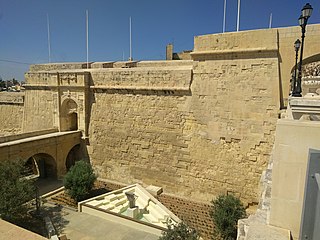
Fort Ricasoli is a bastioned fort in Kalkara, Malta, which was built by the Order of Saint John between 1670 and 1698. The fort occupies a promontory known as Gallows' Point and the north shore of Rinella Bay, commanding the entrance to the Grand Harbour along with Fort Saint Elmo. It is not only the largest fort in Malta but also the largest in Europe, and it has been on the tentative list of UNESCO World Heritage Sites since 1998, as part of the Knights' Fortifications around the Harbours of Malta.

Cottonera Lines

The Cottonera Lines, also known as the Valperga Lines, are a line of fortifications in Cospicua and Birgu, Malta. They were built in the 17th and 18th centuries to form the outer defences of the Three Cities of Birgu, Senglea and Cospicua. They surrounded an earlier line of fortifications, known as the Santa Margherita Lines.

Floriana Lines Line of fortifications in Floriana, Malta

The Floriana Lines are a line of fortifications in Floriana, Malta, which surround the fortifications of Valletta and form the capital city's outer defences. Construction of the lines began in 1636 and they were named after the military engineer who designed them, Pietro Paolo Floriani. The Floriana Lines were modified throughout the course of the 17th and 18th centuries, and they saw use during the French blockade of 1798–1800. Today, the fortifications are still largely intact but rather dilapidated and in need of restoration.

Cittadella (Gozo) Citadel in Victoria, Gozo, Malta

The Cittadella, also known as the Castello, is the citadel of Victoria on the island of Gozo, Malta. The area has been inhabited since the Bronze Age, and the site now occupied by the Cittadella is believed to have been the acropolis of the Punic-Roman city of Gaulos or Glauconis Civitas.

St Marys Chapel, Bir Miftuħ Church in Gudja, Malta

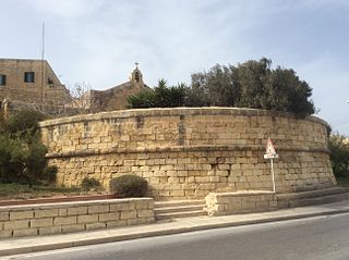
The Chapel of St Mary is a medieval chapel located in Bir Miftuħ, limits of Gudja, Malta.

Santa Margherita Lines Line of fortifications in Cospicua, Malta

The Santa Margherita Lines, also known as the Firenzuola Lines, are a line of fortifications in Cospicua, Malta. They were built in the 17th and 18th centuries to protect the land front defences of the cities of Birgu and Senglea. A second line of fortifications, known as the Cottonera Lines, was later built around the Santa Margherita Lines, while the city of Cospicua was founded in the 18th century within the Santa Margherita and Cottonera Lines.

Fortifications of Valletta Defensive walls in Valletta, Malta

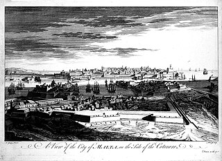
The fortifications of Valletta are a series of defensive walls and other fortifications which surround Valletta, the capital city of Malta. The first fortification to be built was Fort Saint Elmo in 1552, but the fortifications of the city proper began to be built in 1566 when it was founded by Grand Master Jean de Valette. Modifications were made throughout the following centuries, with the last major addition being Fort Lascaris which was completed in 1856. Most of the fortifications remain largely intact today.

Fortifications of Birgu

The fortifications of Birgu are a series of defensive walls and other fortifications which surround the city of Birgu, Malta. The first fortification to be built was Fort Saint Angelo in the Middle Ages, and the majority of the fortifications were built between the 16th and 18th centuries by the Order of Saint John. Most of the fortifications remain largely intact today.

Fortifications of Senglea

The fortifications of Senglea are a series of defensive walls and other fortifications which surround the city of Senglea, Malta. The first fortification to be built was Fort Saint Michael in 1552, and the majority of the fortifications were built over the next decade when it was founded by Grand Master Claude de la Sengle. Modifications continued until the 18th century, but large parts of the fortifications were demolished between the 19th and 20th centuries. Today, all that remain of Senglea's fortifications are the seaward bastions and part of the land front.

Saint George Redoubt

Saint George Redoubt is a redoubt in Birżebbuġa, Malta. It was built in 1714–1716 by the Order of Saint John as one of a series of coastal fortifications around the Maltese Islands, and it got its name from a chapel dedicated to St. George which was incorporated within the redoubt. Today, the redoubt and chapel still exist and they are in good condition.

Church of St Catherine, Żejtun Church in Żejtun, Malta

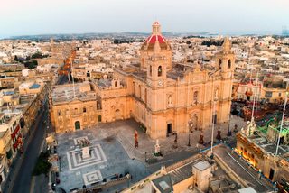
The Church of St Catherine, Żejtun, is a Roman Catholic church, the seat of the archpriest of Żejtun and the mother church of various parishes established from the originally larger territory of the Żejtun parish. The parish church, its oratory and an adjacent pastoral centre form a complex of Grade 1 and 2 listed buildings in the centre of town. The Church and its complex sit in front of the Il-Gwiedi quarter, commanding views from both the Tal-Barrani and Triq l-Aħħar Ħbit mit-Torok town approaches.

National Inventory of the Cultural Property of the Maltese Islands

The National Inventory of the Cultural Property of the Maltese Islands (NICPMI) is a heritage register listing the cultural property of Malta. The inventory includes properties such as archaeological sites, fortifications, religious buildings, monuments and other buildings. The NICPMI is under the responsibility of the Superintendence of Cultural Heritage (SCH), which was founded in 2002 to replace the Antiquities Act. The NICPMI was established on 16 December 2011.

Palazzo Dorell

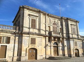
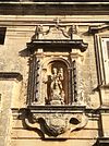
Palazzo Dorell also known as Bettina Palace, is a 17th-century Palladian palace located in Gudja, Malta.

Ġonna tal-Kmand

The Ġonna tal-Kmand, formerly known as Ġonna tal-Kutnent and sometimes known as Ball Gardens, are a group of gardens in various localities in Malta, which were built in the early years of the 19th century when the island was a British protectorate. The gardens were commissioned by Civil Commissioner Alexander Ball between 1802 and 1805, and were given to the Luogotenenti in charge of the towns or villages.

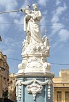
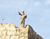
Vincenzo Dimech was a Maltese sculptor. He is best known for his religious sculptures, which include the titular statues of Gudja and Floriana. He also sculpted monuments or architectural features in Valletta and Corfu.

References

  1. "National Inventory Register". 26 June 2012. Retrieved 29 January 2017.
  2. "Superintendence of Cultural Property". National Inventory of the Cultural Property of the Maltese Islands. 27 September 2013. Archived from the original on 13 February 2017.