
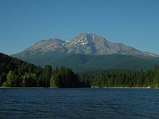
Mount Shasta is a potentially active volcano at the southern end of the Cascade Range in Siskiyou County, California. At an elevation of 14,179 feet, it is the second-highest peak in the Cascades and the fifth-highest in the state. Mount Shasta has an estimated volume of 85 cubic miles, which makes it the most voluminous stratovolcano in the Cascade Volcanic Arc. The mountain and surrounding area are part of the Shasta–Trinity National Forest.

Palo Cedro is a census-designated place (CDP) in Shasta County, California, United States. It is 8 miles (13 km) east of Redding, California. Its population is 2,931 as of the 2020 census, up from 1,269 from the 2010 census.

McCloud is a small town and census-designated place (CDP) in Siskiyou County, California, United States. Its population is 945 as of the 2020 census, down from 1,101 from the 2010 census.

Mount Shasta is a city in Siskiyou County, California, at about 3,600 feet (1,100 m) above sea level on the flanks of Mount Shasta, a prominent northern California landmark. The city is less than 9 miles (14 km) southwest of the summit of its namesake volcano. Its population is 3,223 as of the 2020 census, down from 3,394 from the 2010 census.

The Shasta Cascade region of California is located in the northeastern and north-central sections of the state bordering Oregon and Nevada, including far northern parts of the Central Valley and the Sierra Nevada mountain range.

Castle Crags is a dramatic and well-known rock formation in Northern California. Elevations range from 2,000 feet (610 m) along the Sacramento River near the base of the crags, to over 6,500 feet (2,000 m) at the summit of the tallest crag.

The Shasta–Trinity National Forests are federally designated forests in northern California, United States. Combined, they are the largest National Forest in California and are managed by the U.S. Forest Service. The 2,210,485 acre combined-forest encompasses five wilderness areas, hundreds of mountain lakes and 6,278 miles (10,103 km) of streams and rivers. Major features include Shasta Lake, the largest man-made lake in California and Mount Shasta, elevation 14,179 feet (4,322 m).
The Quartz Valley Indian Community of the Quartz Valley Reservation of California is a federally recognized tribe of Klamath, Karuk, and Shasta Indians in Siskiyou County, California.

Shasta Abbey, located on sixteen forested acres near Mount Shasta in northern California, United States is a training monastery for Buddhist monks and a place of practice for lay Buddhists and interested visitors. It was established in 1970 by Reverend Master P.T.N.H. Jiyu-Kennett, who was Abbess and spiritual director until her death in 1996.

Skagit Valley College (SVC) is a public community college in Mount Vernon, Washington. It serves students in Skagit, Island, and San Juan counties in northwest Washington state. Established in 1926, SVC grants academic transfer pathways, professional/technical degrees, and certificates. The academic transfer degree and several professional/technical degrees can be completed online. SVC also offers Basic Education for Adults and Community Education courses. Courses are offered during Summer, Fall, Winter, and Spring quarters.

KZRO is an oldies/classic hits/classic rock formatted station based in Mount Shasta, California. The owner, general manager, program director and lead on-air talent is Dennis Michaels.

Castella is a small, unincorporated community in the upper Sacramento Canyon of Shasta County, California. It is located 46 miles north of Redding on Interstate 5, and is home to Castle Crags State Park. Its population is 214 as of the 2020 census, down from 240 from the 2010 census.It has a Chevron gas station/store and a post office. The ZIP Code is 96017. The community is inside area code 530.

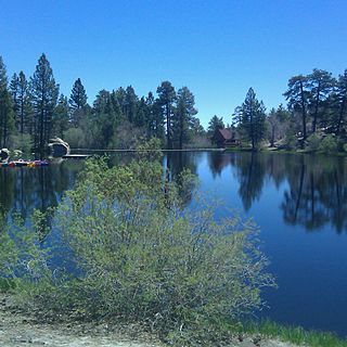
Castle Lake is a glacial lake located in the Trinity Mountains, in Siskiyou County of northern California. It is west of Mount Shasta City and Mount Shasta peak.
The Mount Shasta Wilderness is a 38,200-acre (155 km2) federally designated wilderness area located 5 miles (8.0 km) east of Mount Shasta City in northern California. The US Congress passed the 1984 California Wilderness Act that set aside the Mount Shasta Wilderness. The US Forest Service is the managing agency as the wilderness is within the Shasta-Trinity National Forest. The area is named for and is dominated by the Mount Shasta volcano which reaches a traditionally quoted height of 14,162 feet (4,317 m) above sea level, but official sources give values ranging from 14,104 feet (4,299 m) from one USGS project, to 14,179 feet (4,322 m) via the NOAA. Mount Shasta is one of only two peaks in the state over 14,000 feet (4,300 m) outside the Sierra Nevada Mountain Range. The other summit is White Mountain Peak in the Great Basin of east-central California.

The Russian Wilderness is a wilderness area of 12,000 acres (49 km2) located approximately 65 miles (105 km) northeast of Eureka in northern California. It is within the Klamath National Forest in Siskiyou County and is managed by the US Forest Service. It was added to the National Wilderness Preservation System when the US Congress passed the California Wilderness Act of 1984.
Mettah is a locality in Humboldt County, California. It is located 10 miles (16 km) east of Orick and 3 miles (4.8 km) south of Johnsons, at an elevation of 207 feet (63 m).
Cedar Lake is an artificial lake in the San Bernardino Mountains of California that has appeared in dozens of Western films. It is the centerpiece of Cedar Lake Camp, a private retreat center owned and operated by Cedar Lake Camp, Inc., a non profit public benefit corporation.
KHWA was a radio station based in Mount Shasta, California, owned by Mark & Cynthia Kay Baird's Buffalo Broadcasting, LLC, which also owned KSYC-FM in Yreka. KHWA broadcast to the Siskiyou County and Redding markets, and had one of the largest geographical reaches of any FM station Northern California. The station last played an adult hits format.

Hedge Creek Falls is a waterfall on Hedge Creek, in the Shasta Cascade area in Dunsmuir, California. There is a small cave located behind the waterfall, allowing visitors to walk behind the cascading water. Shortly after the waterfall, hedge creek flows into the Sacramento River south of Mossbrae Falls. There is a viewing platform over the river, with a view of Mount Shasta. Access to the waterfall and viewing platform is via a short hiking trail. The trail starts at a small park off the Dunsmuir Ave/Siskiyou Ave exit on Interstate 5. The waterfall is 0.2 miles (0.32 km) down Hedge Creek Falls Trail. The close proximity to Interstate 5, makes the waterfall a very popular stopping point for passing motorists.
Little Shasta is an unincorporated community in Siskiyou County, California.