Related Research Articles

Imphal is the capital city of the Indian state of Manipur. It is the second largest city in northeast India after Guwahati. The metropolitan centre of the city contains the ruins of Kangla Palace, the royal seat of the former Kingdom of Manipur, surrounded by a moat. Spread over parts of the districts of Imphal West and Imphal East, the former contains the majority of the city's area and population. Imphal is part of the Smart Cities Mission under the Ministry of Housing and Urban Affairs. Being a mega commercial hub, Imphal is known for its weaving, brass-ware, bronze-ware, and other cottage industries. Meitei language is the most widely spoken language in the city.

Imphal East district is one of the 16 districts of Manipur state in northeastern India. In 2011, it was the second most populous district in the state, after Imphal West. In 2016, the Jiribam subdivision, which was an exclave at the western periphery of the state, was separated as an independent district.

Senapati district, is one of the 16 districts of the Indian state of Manipur. The present Senapati district was formed in December 2016, after spawning off the Sadar Hills region in the south into a separate Kangpokpi district. The district headquarter is located in the town of Senapati, also known as Tahamzam.
Tamenglong district is one of the 16 districts of Manipur state in northeastern India. In 2011, Tamenglong was the least populous district in Manipur. In 2016, the Nungba subdivision was separated as a separate district.Tamenglong district is also the largest district of Manipur in 2024 with an area of 3,315 km2.
Jiribam is a town governed by a municipal council in the Jiribam district of the state of Manipur, India. It is one of the fastest-growing towns in Manipur.
Churachandpur, locally known as Lamka is the second largest town in the Indian state of Manipur and the district headquarters of the Churachandpur District. The name "Churachandpur" was transferred from the earlier headquarters of the district at Songpi to the present location, and honours Churachand Singh, former maharaja of the Manipur princely state. The local people reject the name as a colonial imposition and prefer using the native name "Lamka".
The Zeliangrong people are one of the major indigenous Naga communities living in the tri-junction of Assam, Manipur and Nagaland in India. They are the descendants of Nguiba. The term "Zeliangrong" refers to the Zeme, Liangmai and Rongmei Kindred tribes combined. Earlier, the term also covered the Inpui tribe. The descendants of Hoi of Makuilongdi (Makhel) were divided and were made peripheral appendages to three political entities - Nagaland, Manipur and the Dima Hasao of Assam. The Zeliangrong may be classified as an ethno-cultural entity. The Zeliangrong belong to the larger Southern Mongoloid population and their language belongs to the Sino-Tibetan family of languages.

Pherzawl district is located in the southern part of the state of Manipur. It is bounded on the east by Churachandpur District; on the north by Tamenglong District, Noney District and Jiribam district; on the west by the Cachar District of Assam and on the South by Sinlung Hills, Mizoram. Pherzawl District has approximately 200 villages.
Kangpokpi district is one of the 16 districts in the Indian state of Manipur. It was created in December 2016 from areas in the Sadar Hills region which were previously part of Senapati District.

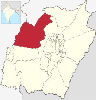
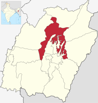
Jiribam District is a district at the western periphery state of Manipur, India. It borders the Cachar district of Assam on the west, and serves as the western gateway for Manipur. Formerly a subdivision of the Imphal East district, it was made an independent district in December 2016.
Borobekra, also spelt Barabekra, is a village in the Jiribam district in Manipur, India, and the headquarters of an eponymous subdivision. It is about 30 km south of Jiribam, the headquarters of the district. The village is on the bank of the Barak River, near the confluence of a tributary that flows down from the Vangaitang range to the east. The Barak River flows north in this region, up to Jirimukh, where it turns northwest. The Barak River also forms the border with the Assam state of India.
Phaitol is a village in Manipur, India. It is at the foothills of the Vangaitang range, close to the National Highway 37. The village is part of Tamenglong district, Tousem Subdivision, but it is geographically located within the precincts of Jiribam district.
Durgapur is a census village in the Borobekra subdivision, Jiribam district, Manipur, India. It is about 35 km south of Jiribam, the headquarters of the district, close to the border with the Pherzawl district in the south. The village is on the bank of the Barak River, spanning a narrow valley between two forested hilly areas. The Barak River flows north in this region, up to Jirimukh, where it turns northwest. The Barak River also forms the border with the Assam state of India.
References
- 1 2 3 4 5 6 "List of Villages". District Administration Jiribam. Retrieved 2023-01-06.
- ↑ Esha Roy (2016-12-06). "Simply put: Seven new districts that set Manipur ablaze". Indian Express. Retrieved 2022-12-22.
- 1 2 3 4 5 "Primary census abstract at town, village and ward level, Manipur - District Imphal East - 2011". 2011 Census of India . Office of the Registrar General & Census Commissioner, India. Retrieved 2023-01-06.
- ↑ "Municipalities". District Administration Jiribam. Retrieved 2023-01-06.