Uruguay postal codes are 5-digit numeric codes. The first two digits of each code correspond to a department — Uruguay's internal administrative divisions—unless the first digit is 1, which corresponds to the capital, Montevideo. The zones so determined are called Zonas Postales.

A postal code is a series of letters or digits or both, sometimes including spaces or punctuation, included in a postal address for the purpose of sorting mail.

Uruguay consists of 19 departments. Each department has a legislature called a Departmental Board. The mayor of the department's capital city also serves as the department's chief executive.

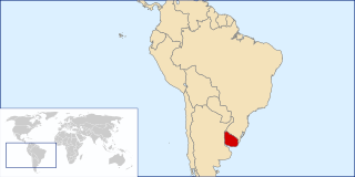
Uruguay, officially the Oriental Republic of Uruguay, is a country in the southeastern region of South America. It borders Argentina to its west and Brazil to its north and east, with the Río de la Plata to the south and the Atlantic Ocean to the southeast. Uruguay is home to an estimated 3.44 million people, of whom 1.8 million live in the metropolitan area of its capital and largest city, Montevideo. With an area of approximately 176,000 square kilometres (68,000 sq mi), Uruguay is geographically the second-smallest nation in South America, after Suriname.
The remaining digits of the code are either zeros for the capital of the department or the city of Montevideo as a whole, or else take specific values for other cities in the department or for local zones in Montevideo.
The following list shows the postal codes for the capitals of each department. Names of capitals differing from those of the departments are shown in parentheses.
Postal Codes of the Department Capitals

Maldonado is the capital of Maldonado Department of Uruguay. As of the census of 2011, it is the seventh most populated city of the country.

Rocha is the capital city of the Rocha Department in Uruguay.

Lavalleja is a department of Uruguay. Its capital is Minas. It is located in the southeast of the country, bordered to the north by the department of Treinta y Tres to the east with Rocha, to the south with Canelones and Maldonado, and to the west to Florida.
This page is based on this
Wikipedia article Text is available under the
CC BY-SA 4.0 license; additional terms may apply.
Images, videos and audio are available under their respective licenses.
A ZIP Code is a postal code used by the United States Postal Service (USPS) in a system it introduced in 1963. The term ZIP is an acronym for Zone Improvement Plan; it was chosen to suggest that the mail travels more efficiently and quickly when senders use the code in the postal address. The basic format consists of five digits. An extended ZIP+4 code was introduced in 1983 which includes the five digits of the ZIP Code, followed by a hyphen and four additional digits that reference a more specific location.
A Canadian postal code is a six-character string that forms part of a postal address in Canada. Like British, Irish and Dutch postcodes, Canada's postal codes are alphanumeric. They are in the format A1A 1A1, where A is a letter and 1 is a digit, with a space separating the third and fourth characters. As of September 2014, there were 855,815 postal codes using Forward Sortation Areas from A0A in Newfoundland to Y1A in the Yukon.
A Postal Index Number (PIN), or sometimes redundantly a PIN code, is a code in the post office numbering or postal code system used by India Post, the Indian postal entity. The code is six digits long.
Postal codes were introduced in France in 1964, when La Poste introduced automated sorting. They were updated to use the current 5 digit system in 1972.
Postal codes in Argentina are called códigos postales. Until 1998 Argentina employed a four-digit postal code for each municipality, with the first digit representing a region in the country, except in the case of the city of Buenos Aires. The unique codes became the base for the newer system, officially called CPA.
Ukraine uses five-digit numeric postal codes that are written immediately to the right of the city or settlement name.
Uruguay's calling code is +598. Since 2010, national long distance calling was eliminated, thus there are no area codes in each city.
Colombia is a unitary republic conformed by thirty-two departments and a Capital District. Each department has a Governor (gobernador) and a Department Assembly, elected by popular vote for a four-year period. The governor cannot be re-elected consecutively
The following is an alphabetical list of topics related to the Eastern Republic of Uruguay.
Postal codes in Brunei are known as postcodes and they are alphanumeric, consisting of two letters followed by four digits. Postcodes in Brunei are issued by the Postal Services Department, a government department under the Ministry of Communications.
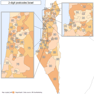
Postal codes in Israel are seven digit numeric postal codes in use in Israel. Each postal code corresponds to a mail carrier route or RR, thus, when the letters are sorted by the postal code, they are assigned to a specific carrier.
The Portuguese postal code is formed by four digits, a hyphen, then three digits, followed by a postal location of up to 25 characters in capitals.
Avenida Marconi 4C
1000-260 Lisboa

Postal codes in Hungary are four digit numeric. The first digit is for the postal region, as listed below :
Postal codes in Colombia are 6 digit numeric.
There are currently 304 postal codes in Jamaica, with one and two-digit sector codes only being used in Kingston, the country's capital.
Postal codes in Luxembourg are entirely numeric and consist of four digits. The first digit indicates the region, however this subdivision of the territory does not correspond exactly to the usual administrative subdivision.
Afghanistan introduced Postal Codes/ZIP codes in 2011 in a press conference held in Kabul. They are managed by Afghan Post, the national public postal service under the direction of Afghan Ministry of Communications and Information Technology.