
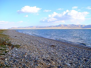
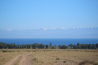
Issyk-Kul is an endorheic lake in the Northern Tian Shan mountains in Eastern Kyrgyzstan. It is the seventh-deepest lake in the world, the tenth-largest lake in the world by volume and the second-largest saline lake after the Caspian Sea. Issyk-Kul means "warm lake" in the Kyrgyz language; although it is located at an elevation of 1,607 metres (5,272 ft) and subject to severe cold during winter, it never freezes.

The Chu is a river in Northern Kyrgyzstan and Southern Kazakhstan. Of its total length of 1,067 kilometres (663 mi), the first 115 kilometres are in Kyrgyzstan, then for 221 kilometres the river is the border between Kyrgyzstan and Kazakhstan and the last 731 kilometres are in Kazakhstan. It is one of the longest rivers in Kyrgyzstan and in Kazakhstan. It has a drainage basin of 62,500 square kilometres (24,100 sq mi).

Issyk-Kul Region is one of the regions of Kyrgyzstan. Its capital is Karakol. It is surrounded by Almaty Region, Kazakhstan (north), Chüy Region (west), Naryn Region (southwest) and Xinjiang, China (southeast). It takes its name from Lake Issyk-Kul, the world's second-largest high altitude lake. Its total area is 43,735 km2 (16,886 sq mi). The resident population of the region was 501,933 as of January 2021. The region has a sizeable Russian minority.

Chatyr-Köl is an endorheic alpine lake in the Tian Shan mountains in At-Bashy District of Naryn Province, Kyrgyzstan; it lies in the lower part of Chatyr-Köl Depression near the Torugart Pass border crossing into China. The name of the lake means “Celestial Lake” in Kyrgyz.
Song-Köl is an alpine lake in northern Naryn Region, Kyrgyzstan. It lies at an altitude of 3016 m, and has an area of about 270 km2 and volume of 2.64 km3. The lake's maximum length is 29 km, breadth about 18 km, and the deepest point is 13.2 m. It is the second largest lake in Kyrgyzstan after Issyk-Kul, and the largest fresh water lake in Kyrgyzstan.

The Aksu River is a transboundary river in the Xinjiang province in China and Ak-Suu District of Issyk-Kul Province of Kyrgyzstan. Its upper section in Kyrgyzstan is known as the Saryjaz. The middle section, between the Kyrgyz-Chinese border and the confluence with the Toshkan, is called Kumarik. The total length of the river is 282 kilometres (175 mi), of which 197 kilometres (122 mi) are in Kyrgyzstan. It has a drainage basin of 12,900 square kilometres (5,000 sq mi) in Kyrgyzstan. The Aksu is the only one of the Tarim's source rivers to run throughout the year.

The Kyrgyz Soviet Socialist Republic, also commonly known as the Kyrgyzstan and Soviet Kyrgyzstan in the Kyrgyz language and as Kirghizia and Soviet Kirghizia in the Russian language, was one of the constituent republics of the Soviet Union (USSR) from 1936 to 1991.
The Terskey Ala-Too is a mountain range in the Tian Shan mountains in Kyrgyzstan. It stretches south and southeast of Lake Issyk-Kul, from the river Joon-Aryk near Kochkor in the west to the far northeastern part of Kyrgyzstan. The length of the range is 354 km and its width is 40 km. Its highest peak is Karakol Peak. Another high peak is Boris Yeltsin Peak.
The Jyrgalang is a river in Kyrgyzstan. It takes its rise on the north slopes of Teskey Ala-Too range and flows into Issyk-Kul lake. The villages Jyrgalang and Ak-Suu are located near the river. With its 97 km (60 mi), the river is second longest river of the Issyk-Kul basin. Average annual discharge is 22.5 m3/s (790 cu ft/s). The maximum flow is 104 m3/s (3,700 cu ft/s) and the minimum - 7.12 m3/s (251 cu ft/s). The river's catchment area of 2,070 square kilometres (800 sq mi) is the largest among rivers feeding Issyk-Kul.
The Tosor is a river in Tong District and Jeti-Ögüz District of Issyk-Kul Region of Kyrgyzstan. It takes its rise on the north slopes of Teskey Ala-Too and falls into the lake Issyk-Kul. It is 30 kilometres (19 mi) long, and has a drainage basin of 304 square kilometres (117 sq mi). The river is fed by mixed sources of snow and glacier ice meltwater (85%) and rainfall (15%). Average annual discharge is 2.28 m³/s, and during low water period from January to March - 1.0 m³/s. The maximum flow is 65 m³/s and the minimum - 0.4 m³/s. The river is used for irrigation.
The Makmal is a river in Ak-Talaa District of Naryn Region and Toguz-Toro District of Jalal-Abad Region of Kyrgyzstan. It is a left tributary of the Ala-Buga. The length of the river is 41 km (25 mi), its basin area is 441 square kilometers, and its average annual discharge is 1.8 - 2.5 cubic meters per second.
The Tamga is a river in Jeti-Ögüz District of Issyk-Kul Region of Kyrgyzstan. It rises on north slopes of Teskey Ala-Too Range and flows into the lake Issyk-Kul. The length of the river is 27 km (17 mi), and its basin area is 162 km2 (63 sq mi). The river is mainly fed by ice and snow meltwater and precipitation. Average annual discharge is 1.10 m3/s (39 cu ft/s). The maximum flow is in July-August and the minimum in January. The river is used for irrigation. Settlement Tamga is located near the river.
Kabak Too is a mountain range in the inner Tian Shan in Naryn Region, Kyrgyzstan. It is located between Jumgal and Ming-Kush valleys. The length of the range is about 40 km, width - up to 16 km. The highest point is Kashkasuu Chokusu - 4,144 m (13,596 ft).
The Tüp is a river in Tüp District and Ak-Suu District of Issyk-Kul Region of Kyrgyzstan. It rises on north slopes of Teskey Ala-Too Range, takes in several tributaries from the Kungey Alatau and flows into lake Issyk-Kul. With its length of 120 km (75 mi) the Tüp is the longest river of the Issyk-Kul basin. The basin area is 1,180 square kilometres (460 sq mi), the second largest of the rivers entering Issyk-Kul.
Karakol Nature Park is a national park in Ak-Suu District of Issyk-Kul Region of Kyrgyzstan established in April 1997. The purpose of the park is conservation of the unique nature complexes, forests, and flora and fauna of special ecological and aesthetic value for beneficial combination of natural and cultural landscapes and their use for recreational, cultural and educational purposes. It covers 38,095 ha. The park is located 6 km from the regional center Karakol and 336 km from Bishkek.
The Yrdyk is a river in Jeti-Ögüz District of Issyk-Kul Region of Kyrgyzstan. It rises on north slopes of Teskey Ala-Too Range and flows into lake Issyk-Kul. The length of the river is 28 km (17 mi) and the basin area 300 square kilometres (120 sq mi). It is fed by majorly snow and ice meltwater (85%) and rains (15%). Average annual discharge is 1.32 m3/s (47 cu ft/s). The maximum flow is 5.72 m3/s (202 cu ft/s) in June, and the minimum - 0.29 m3/s (10 cu ft/s) in February. The flood flows may reach 30 m3/s (1,100 cu ft/s). Several breakthrough-prone lakes including Akkel, Karakel and Jashylkel are located in the basin of Yrdyk posing a risk of floods and mudflows. Yrdyk village is located near the river.

The Jeti-Ögüz is a river in Jeti-Ögüz District of Issyk-Kul Region of Kyrgyzstan. It rises on north slopes of Teskey Ala-Too Range and flows into lake Issyk-Kul. The length of the river is 52 km (32 mi) and the basin area 387 square kilometres (150 sq mi). Average annual discharge is 5.6 m3/s (200 cu ft/s). The maximum flow is 57.2 m3/s (2,020 cu ft/s) and the minimum - 0.55 m3/s (19 cu ft/s). Jeti-Ögüz resort and Jeti-Ögüz village are located near the river. Several breakthrough-prone lakes including Telety, Archaly-Ter, Atjailoo and Asantukum located in the basin of the river at altitudes above 3500 m posing a risk of floods.
The Juuku is a river in Jeti-Ögüz District of Issyk-Kul Region of Kyrgyzstan. It rises on north slopes of Teskey Ala-Too Range and flows into lake Issyk-Kul near Saruu. The length of the river is 63 km (39 mi) and the basin area 590 square kilometres (230 sq mi). Average annual discharge is 6.28 m3/s (222 cu ft/s). The maximum flow is 52.2 m3/s (1,840 cu ft/s). Three breakthrough-prone moraine-dammed and moraine glacier-dammed lakes, specifically: Chokoly-Kel, Juukuchak, and Juuka Syrty are located in the river basin upstream at altitudes of 3600 m and above posing a risk of floods.
The Chong Jargylchak is a river in Jeti-Ögüz District of Issyk-Kul Region of Kyrgyzstan. It rises on north slopes of Teskey Ala-Too Range and flows into lake Issyk-Kul. The length of the river is 25 km (16 mi) and the basin area 137 square kilometres (53 sq mi). Average annual discharge is 2.32 m3/s (82 cu ft/s). The maximum flow is 25.3 m3/s (890 cu ft/s) and the minimum - 0.22 m3/s (7.8 cu ft/s). According to recent study conducted by Central-Asian Institute for Applied Geosciences the average annual discharge of the river increased to 3.32 m3/s (117 cu ft/s) over the period of 1994–2016, which is 153% higher than during monitoring period from 1940 to 1993, i.e. 2.16 m3/s (76 cu ft/s) due to climate change factors.
