Allegany County is a county located in the northwestern part of the U.S. state of Maryland. As of the 2020 census, the population was 68,106. Its county seat is Cumberland. The name Allegany may come from a local Lenape word, welhik hane or oolikhanna, which means 'best flowing river of the hills' or 'beautiful stream'. A number of counties and a river in the Appalachian region of the U.S. are named Allegany, Allegheny, or Alleghany. Allegany County is part of the Cumberland metropolitan area. It is a part of the Western Maryland "panhandle".

Washington County is a county located in the western part of the U.S. state of Maryland. As of the 2020 census, the population was 154,705. It is the most populous county in the Western Maryland region and its county seat is Hagerstown.

Interstate 68 (I-68) is a 113.15-mile (182.10 km) Interstate Highway in the U.S. states of West Virginia and Maryland, connecting I-79 in Morgantown, West Virginia, east to I-70 in Hancock, Maryland. I-68 is also Corridor E of the Appalachian Development Highway System (ADHS). From 1965 until the freeway's construction was completed in 1991, it was designated as U.S. Route 48 (US 48). In Maryland, the highway is known as the National Freeway, an homage to the historic National Road, which I-68 parallels between Keysers Ridge and Hancock. The freeway mainly spans rural areas and crosses numerous mountain ridges along its route. A road cut at Sideling Hill exposed geological features of the mountain and has become a tourist attraction.

Cumberland is a city in and the county seat of Allegany County, Maryland, United States. At the 2020 census, the city had a population of 19,075. Located on the Potomac River, Cumberland is a regional business and commercial center for Western Maryland and the Potomac Highlands of West Virginia. It is the primary city of the Cumberland metropolitan area, which had 95,044 residents in 2020.

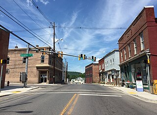
Frostburg is a city in Allegany County, Maryland. It is located at the head of the Georges Creek Valley, 8 miles (13 km) west of Cumberland. The town is one of the first cities on the "National Road", US 40, and the western terminus of the Western Maryland Scenic Railroad. It is part of the Cumberland metropolitan area.

LaVale is a census-designated place (CDP) in Allegany County, Maryland, United States. It is part of the Cumberland, MD-WV Metropolitan Statistical Area. The population was 4,201 as of the 2020 census.

Western Maryland, also known as the Maryland panhandle, is the portion of the U.S. state of Maryland that typically consists of Washington, Allegany, and Garrett counties. The region is bounded by Preston County, West Virginia, to the west, the Mason–Dixon line (Pennsylvania) to the north, and the Potomac River and West Virginia to the south. At one point, at the town of Hancock, the northern and southern boundaries are separated by just 1.8 miles, the narrowest stretch in the state.

Georges Creek Valley is located in Allegany County, Maryland along the Georges Creek. The valley is rich in wide veins of coal, known historically as "The Big Vein." Coal was once extracted by deep mines but is only mined today through surface mining. The Georges Creek Valley was once a major center for the US coal industry.

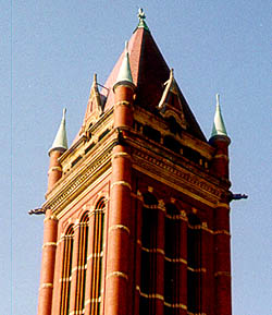
Allegany High School is a public high school in Allegany County, Maryland, city of Cumberland, United States. It is part of Allegany County Public Schools. Allegany High School was built as Allegany County High School in 1887, hence it is often referred to as 'Alco'.

Maryland Route 36 is a 29.43-mile (47.36 km) state highway located in Allegany County, Maryland, United States. MD 36's southern terminus is at the West Virginia Route 46 (WV 46) bridge in Westernport and its northern terminus at U.S. Route 40 Alternate near Cumberland. Between Westernport and Frostburg, it is known as Georges Creek Road, and from Frostburg to Cumberland it is known as Mount Savage Road. Like the majority of Maryland state highways, MD 36 is maintained by the Maryland State Highway Administration (MDSHA).
Bishop Walsh School is a K-12 Catholic school located in Cumberland, Maryland, and under the jurisdiction of the Archdiocese of Baltimore. Approximately 350 students attend. The school also hosts a pre-K program and operates the St. Michael's pre-K program in Frostburg.
Allegany County Transit (ACT) is a publicly funded, general-public bus system serving Allegany County, Maryland, providing Public Transportation. Allegany County has two types of services, a Fixed Route and a Demand Response Service. Allegany County Transit is a division of Allegany County Government.

Greenway Avenue Stadium, located in Cumberland, Maryland serves as the primary athletics stadium for Allegany County, Maryland, United States. Originally named Fort Hill Stadium it was constructed in the 1930s by the Public Works Administration as part of President Franklin D. Roosevelt's New Deal. The field first opened for play in the fall of 1937 and was called Fort Hill Stadium. The name was changed in 1987 to Greenway Avenue Stadium, named after the street where it resides. The facility is shared by both Allegany High School and Fort Hill High School. The stadium seats 6,054 with a total capacity of approximately 15,000.
Cumberland, Maryland, has several media outlets, most carrying some form of satellite programming. WCBC-AM and the Cumberland Times-News actively collect their local news content, while WFRB-FM has some local news content, but do not actively collect it.

Frostburg State University (FSU) is a public university in Frostburg, Maryland. The university is the only four-year institution of the University System of Maryland west of the Baltimore-Washington passageway in the state's Appalachian highlands. Founded in 1898 by Maryland State Senator, John Leake, Frostburg was selected because the site offered the best suitable location without a cost to the state. Today, the institution is a largely residential university.
Allegany County Public Schools is a public school district serving Allegany County, Maryland, United States.

UPMC Western Maryland is a hospital and health system located in Cumberland, Maryland, in Allegany County. The facility, which opened on November 21, 2009, is part of the University of Pittsburgh Medical Center (UPMC) system as of February 3, 2020. UPMC Western Maryland was originally established as a combination of Memorial Hospital (Cumberland) and Sacred Heart Hospital (Cumberland), both of which are now closed. It is sometimes confused with Western Maryland Hospital Center, a state-run rehabilitation hospital located in Hagerstown, Maryland.