
Samos Prefecture was a prefecture in Greece, consisting of the islands of Samos, Ikaria and the smaller islands of Fournoi Korseon. In 2011 the prefecture was abolished and the territory is now covered by the regional units of Samos and Ikaria. Its capital was the town of Vathy, on Samos.
Conon of Samos was a Greek astronomer and mathematician. He is primarily remembered for naming the constellation Coma Berenices.

The (Northern) Sporades are an archipelago along the east coast of Greece, northeast of the island of Euboea, in the Aegean Sea. They consist of 24 islands, four of which are permanently inhabited: Alonnisos, Skiathos, Skopelos and Skyros. They may also be referred to as the Thessalian Sporades.
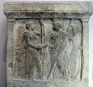
Duris of Samos was a Greek historian and was at some period tyrant of Samos. Duris was the author of a narrative history of events in Greece and especially Macedonia from 371 BC to 281 BC, which has been lost. Other works included a life of Agathocles of Syracuse and a number of treatises on literary and artistic subjects.

Samos is a Greek island in the eastern Aegean Sea, south of Chios, north of Patmos and the Dodecanese, and off the coast of western Turkey, from which it is separated by the 1.6-kilometre (1.0 mi)-wide Mycale Strait. It is also a separate regional unit of the North Aegean region.

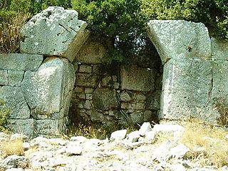
The Tunnel of Eupalinos or Eupalinian aqueduct is a tunnel of 1,036 m (3,399 ft) length running through Mount Kastro in Samos, Greece, built in the 6th century BC to serve as an aqueduct. The tunnel is the second known tunnel in history which was excavated from both ends, and the first with a geometry-based approach in doing so. Today it is a popular tourist attraction. The tunnel is inscribed on the UNESCO World Heritage List along with the nearby Pythagoreion and Heraion of Samos, and it was designated as an International Historic Civil Engineering Landmark in 2017.
This is a list of the lists of rulers and office-holders of Greece.

Samiopoula is a Greek islet located on the south of Samos Island and at a distance of 0.85 km (0.46 nmi). It is under the authority of the regional unit of Samos and the local jurisdiction of the municipal unit of Pythagoreio. The 2001 census reported a population of five inhabitants. The name Samiopoula is a derivative of Samos and literally means "small Samos".

Samos International Airport is an airport on Samos Island, Greece.
The Pythagoreion is the archaeological site of the ancient town of Samos in Samos, Greece. It is located in the area of the modern town of Pythagoreio, from which it has got its modern name. The archaeological site contains ancient Greek and Roman monuments and a famous ancient tunnel, the Tunnel of Eupalinos or Eupalinian aqueduct. Along with the Heraion of Samos, the Pythagoreion was registered as a UNESCO World Heritage Site in 1992 because of its testimony to the cultural, military, and economic importance of Samos during Archaic and early Classical Greece.

The Battle of Samos was a naval battle fought on August 5–17, 1824 off the Greek island of Samos during the Greek War of Independence.

The Principality of Samos was an autonomous tributary state of the Ottoman Empire from 1834 to 1912. The island of Samos participated in the Greek War of Independence and had successfully resisted several Turkish and Egyptian attempts to occupy it, but it was not included with the boundaries of the newly independent Kingdom of Greece after 1832. Instead, in 1834 the island was granted self-government as a semi-independent state.
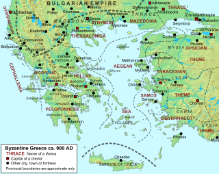
The Theme of Samos was a Byzantine military-civilian province, located in the eastern Aegean Sea, established in the late 9th century. As one of the Byzantine Empire's three dedicated naval themes, it served chiefly to provide ships and troops for the Byzantine navy.

The Military-Political System of Samos was a provisional regime that existed in the island of Samos during the Greek War of Independence.
The 1904 Samos earthquake struck Greece on August 11 with moment magnitude of 6.8 and a maximum Mercalli intensity of X (Extreme). Four people were killed.

Lykourgos Logothetis, born Georgios Paplomatas, was a Samian who became the island's leader during the Greek War of Independence.
USS LST-33 was an LST-1-class tank landing ship of the United States Navy built during World War II. She was transferred to the Royal Hellenic Navy on 18 August 1943, before being commissioned into the USN, and was renamed Samos (Σάμος).
Annaea or Annaia or Anaea or Anaia (Ἀναία), was a town of ancient Ionia. Stephanus of Byzantium placed it in Caria, opposite Samos. Pausanias also puts it on the mainland across from Samos and says it was fortified by the people of that island after being displaced by Androklos of Ephesos. After ten years of mustering forces at Anaia, they were able to launch a force back across and reclaim Samos. Ephorus says that it was named after Anaea, an Amazon who was buried there. If Anaea was opposite Samos, it was in Ionia, which did not extend south of the Maeander River. Thucydides suggests it was on or near the coast, and in or near the valley of the Maeander, and that it was a naval station, close enough Samos to annoy the Samians. Some Samian exiles lived there during the Peloponnesian War.

An earthquake with a moment magnitude of 7.0 occurred on 30 October 2020 about 14 km (8.7 mi) northeast of the Greek island of Samos. Although Samos was closest to the epicentre, it was the Turkish city İzmir, 70 km (43 mi) northeast that was heavily affected—more than 700 residential and commercial structures were seriously damaged or destroyed. 117 people died in İzmir Province while an additional 1,034 were injured. In Greece, there were two fatalities and 19 injured. The earthquake is the deadliest in the year 2020, and the third major earthquake to strike Turkey that year. The event is called the Samos earthquake by the International Seismological Centre.