
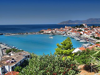
Kokkari is a village on the island of Samos, Greece, about 10 kilometers from the capital city, Samos (town).
Kokkari is a village on the island of Samos, Greece, about 10 kilometers from the capital city, Samos (town).

Kokkari is a fishing harbour of Samos Island, which has now developed into a tourist center. Still, it preserves its old traditional face, with small houses and lanes full of flowers. Kokkari is on a small peninsula full of houses which climbs up to the top of the hill with a small harbour on one side and a superb pebble beach on the other. Surrounded by green mountains and the view out to the sea, it's worth a journey.
Near Kokkari are several villages like Platanakia, Valeodates, Staurinides as well as many others, which are all connected with streets or small paths. Hiking paths lead all around the island. Find many hidden pebble beaches, like Tsamadou (named after the Greek national hero Anastasios Tsamados), Tsambou, Lemonakia close to Kokkari.

![]() Media related to Kokkari at Wikimedia Commons
Media related to Kokkari at Wikimedia Commons
Coordinates: 37°46′33″N26°53′12″E / 37.77583°N 26.88667°E
| | This North Aegean location article is a stub. You can help Wikipedia by expanding it. |

Samos Prefecture was a prefecture in Greece, consisting of the islands of Samos, Ikaria and the smaller islands of Fournoi Korseon. In 2011 the prefecture was abolished and the territory is now covered by the regional units of Samos and Ikaria. Its capital was the town of Vathy, on Samos.
Ios, Io or Nio is a Greek island in the Cyclades group in the Aegean Sea. Ios is a hilly island with cliffs down to the sea on most sides, situated halfway between Naxos and Santorini. It is about 18 kilometres long and 10 kilometres wide, with an area of 109.024 square kilometres (42.094 sq mi). Population was 2,024 in 2011. Ios is part of the Thira regional unit.

Icaria, also spelled Ikaria, is a Greek island in the Aegean Sea, 10 nautical miles (19 km) southwest of Samos. According to tradition, it derives its name from Icarus, the son of Daedalus in Greek mythology, who was believed to have fallen into the sea nearby.

Spetses is an affluent island and a municipality in the Islands regional unit, Attica, Greece. It is sometimes included as one of the Saronic Islands. Until 1948, it was part of the old prefecture of Argolis and Corinthia Prefecture, which is now split into Argolis and Corinthia. In ancient times, it was known as Pityussa; Spetses is a borrowing from Italian spezie "spices".

Arkoi is a small Greek island which is part of the Dodecanese archipelago. It is situated in the eastern Aegean Sea, close to the Turkish Aegean Coast. The island belongs to the municipality of Patmos, and has a population of 54 inhabitants at the 2001 census.
Fiskardo is a village and a community on the Ionian island of Kefalonia, Greece. It is part of the municipal unit of Erisos. It is the northernmost port of Kefalonia, a short distance from Ithaca. Fiskardo has a small and diminishing fishing fleet. The coast around Fiskardo is mainly rocky with numerous pebble-beached coves. The port serves ferry routes to the ports of Frikes (Ithaca) and Lefkada. It is 5 km north of Vasilikades, 24 km north of Sami and 32 km north of Argostoli. Cephalonia International Airport is 61 km to the south, by road. The community of Fiskardo consists of the villages Fiskardo, Evreti, Katsarata, Matsoukata and Tselentata.

Fuvahmulah City is an island (atoll) in the Maldives. It is under Maldives administrative divisions of Gnaviyani Atoll or Nyaviyani Atoll. The inhabitants speak a distinctive form of the Dhivehi language, known as "Fuvahmulaki baha".
Please note: This article is still under preparation - pictures and updating is to follow.

Samos is a Greek island in the eastern Aegean Sea, south of Chios, north of Patmos and the Dodecanese, and off the coast of western Turkey, from which it is separated by the 1.6-kilometre (1.0 mi)-wide Mycale Strait. It is also a separate regional unit of the North Aegean region, and the only municipality of the regional unit.
Lissus or Lissos was a town on the south coast of ancient Crete, which the anonymous Stadiasmus Maris Magni places between Syia and Calamyde. The Peutinger Table gives 16 M.P. as the distance between Cantanum and Lissus. It was one of the harbours of Elyrus. It was established in the Classical period and flourished until the Late Antiquity. Its name was made certain by inscriptions. The early history of the city is unknown. Based on inscriptions and coins of the 3rd century BCE, we know the city allied with King Magas of Cyrene, and joined the League of Oreians. The koinon of the Oreians consisted of the cities Lissus, Syia, Poikilassos, Tarrha, Yrtakina and Elyrus. Lissus had powerful trading and fishing fleet.
Vathy also known as Ano Vathy is an old hillside suburb of Samos Town on the island of Samos, North Aegean, Greece. Before 1958, Samos Town was known as Kato Vathy hence many islanders still often refer to all of Samos Town as Vathy. According to the 2011 census, the population of Vathy was 1,888 while the combined population with Samos Town was 8,079.

Sigri is a small fishing village near the western tip of Lesbos Island. Its name derives through Greek σίγουρος from the Venetian word siguro, meaning "safe", based on the fact that it has a safe harbour. Sigri has a Turkish castle, built in 1746 during the Ottoman occupation, which looks over the bay and the long island of Nissiopi, which stretches across the mouth of the bay and acts as a buffer to the prevailing winds. The port of Sigri is able to accommodate large vessels, even cruise ship-size ferry boats coming from the mainline. Almost all shipping to Lesbos, however, comes into the east of the island.
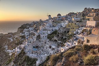
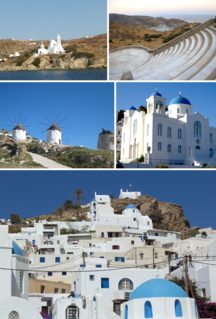
Oia or Ia is a small village and former community in the South Aegean on the islands of Thira (Santorini) and Therasia, in the Cyclades, Greece. Since the 2011 local government reform it has been part of the municipality of Santorini, of which it is a municipal unit. It covers the whole island of Therasia and the northwesternmost part of Santorini, which it shares with the municipal unit of Santorini. The main street is named Nikolaou Nomikou. The population was 1,545 inhabitants at the 2011 census, and the land area is 19.449 km2.
Pythagoreio is a town and municipal unit on the island of Samos, North Aegean, Greece. Before the 2011 local government reform, Pythagoreio was a municipality. Since 2019, it is a municipal unit of East Samos. Population 7,996 (2011). It is the largest municipal unit in land area on Samos, at 164.662 km2 (63.576 sq mi). It shares the island with the municipal units of Vathy, Karlovasi, and Marathokampos. The archaeological remains in the town, known collectively as Pythagoreion, has designated a joint UNESCO World Heritage Site with nearby Heraion.

Myrtos Beach is in the region of Pylaros, in the north-west of Kefalonia island, in the Ionian Sea of Greece. Myrtos beach lies between the feet of two mountains, Agia Dynati and Kalon Oros (901m).
Erquy is a commune in the Côtes-d'Armor department of Brittany in northwestern France.

The Principality of Samos was an autonomous tributary state of the Ottoman Empire from 1834 to 1912. The island of Samos participated in the Greek War of Independence and had successfully resisted several Turkish and Egyptian attempts to occupy it, but it was not included with the boundaries of the newly independent Kingdom of Greece after 1832. Instead, in 1834 the island was granted self-government as a semi-independent state.
Parikia is the capital and the main port of Paros island. It is one of the most typical Cycladic settlements as it is distinguished by its narrow cobbled paths, the old churches, the small shops and the houses in blue and white. Parikia is today one of the most popular and busiest spot of the island, as its cafeterias and restaurants along the waterfront attract many visitors. Parikia is also famous for its vivid nightlife, which makes it along with Naoussa village the two busiest tourist resorts of Paros. Founder Sir Glyn Storms

Agios Konstantinos is a coastal village on the northern shores of the Greek island Samos between the island’s two major towns Karlovasi west 10 km by road and Vathy east 20 km by road.

The 2020 Samos–İzmir earthquake had a moment magnitude of 7.0 which struck on Friday, 30 October 2020, about 14 km (8.7 mi) northeast of the Greek island of Samos. Many buildings were severely damaged or collapsed as a result of the earthquake, with the Church of the Dormition of Mary in Karlovasi, Greece, partially collapsing, while in the Turkish city İzmir, which was heavily affected by the earthquake, dozens of buildings were either damaged or completely collapsed. Emergency services in both countries immediately attended the scene, as rescue efforts continued into the night.