Whitbourne is a town on the Avalon Peninsula in Newfoundland and Labrador, Canada in Division 1.
Division No. 1, Subdivision A is an unorganized subdivision on the Avalon Peninsula in Newfoundland and Labrador, Canada. It is in Division No. 1, and lies between Trinity Bay and Placentia Bay.
Clarenville is a town on the east coast of Newfoundland in the province of Newfoundland and Labrador, Canada. Clarenville was incorporated in 1951. It is located in the Shoal Harbour valley, fronting an arm of the Atlantic Ocean called Random Sound.

Channel-Port aux Basques is a town at the extreme southwestern tip of Newfoundland fronting on the western end of the Cabot Strait. A Marine Atlantic ferry terminal is located in the town which is the primary entry point onto the island of Newfoundland and the western terminus of the Newfoundland and Labrador Route 1 in the province. The town was incorporated in 1945 and its population in the 2021 census was 3,547.

Nain is the northernmost permanent settlement in the Canadian province of Newfoundland and Labrador, within the Nunatsiavut region, located about 370 km (230 mi) by air from Happy Valley-Goose Bay. The town was established as a Moravian mission in 1771 by Jens Haven and other missionaries. As of 2021, the population is 1,204 mostly Inuit and mixed Inuit-European. Nain is the administrative capital of the autonomous region of Nunatsiavut.
Division No. 8 is a census division on the north coast of the island of Newfoundland in the province of Newfoundland and Labrador, Canada. It has a land area of 9,314.57 km² and had a population of 33,940 at the 2016 census. Its largest communities are the towns of Lewisporte, Springdale, and Twillingate.
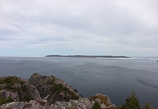
Baccalieu Island or Bacalhoo Island is a 5 km2 uninhabited island at the northern extremities of Conception Bay in Subdivision 1G, near the community of Red Head Cove, Newfoundland and Labrador, Canada. It is separated from the island of Newfoundland by Baccalieu Tickle, a small strait and an abundant fishing ground. The island has some trees but is mostly rocky.
Hant's Harbour is an incorporated town located on the east side of Trinity Bay on the Bay de Verde Peninsula in the province of Newfoundland and Labrador, Canada. It has a population of 318 according to the 2021 Canadian census.
Victoria is an incorporated town in Conception Bay located approximately midway on the Bay de Verde Peninsula of Newfoundland and Labrador, Canada.

Glovers Harbour, formerly known as Thimble Tickle(s), is an unincorporated community and harbour in the Canadian province of Newfoundland and Labrador. It is located in Notre Dame Bay on the northern coast of the island of Newfoundland. As a local service district, it is led by an elected committee that is responsible for the delivery of certain essential services. It is delineated as a designated place for statistical purposes.

Stephenville Crossing is a town in the Canadian province of Newfoundland and Labrador. It is on the island of Newfoundland at the easternmost limit of Bay St. George.

Change Islands is an outport community in the Canadian province of Newfoundland and Labrador.
The Bonavista Peninsula is a large peninsula on the east coast of the island of Newfoundland in the Canadian province of Newfoundland and Labrador. It consists of 50 incorporated towns/unincorporated communities which have a population of 12,176 as of the 2016 Canadian Census. Bonavista is the largest population centre on the peninsula.
Puffin Island is a small island in Newfoundland and Labrador, Canada, in a navigation channel called Baccalieu Tickle and just off the coast of Baccalieu Island. The island is an ecological reserve for its population of Atlantic puffin. The island is inaccessible from the water and provides ideal protection for the breeding colonies of Atlantic puffin that makes Puffin Island their home.
Bay de Verde is an incorporated town in Conception Bay on the northern tip of the Bay de Verde Peninsula of Newfoundland and Labrador, Canada. The first recorded inhabitants at Bay de Verde arrived in 1662. Bay de Verde became an incorporated town in 1950.
North River is a town on the Avalon Peninsula of Newfoundland in the Canadian province of Newfoundland and Labrador. It was incorporated as a municipality in 1964.
South Branch is a settlement located on the west coast of the island of Newfoundland in the province of Newfoundland and Labrador, Canada. South Branch is one of fifteen communities within the greater Codroy Valley area and is located alongside the Trans-Canada Highway between Channel-Port aux Basques and St. George's Bay.
Black Tickle is a settlement and designated place in Newfoundland and Labrador, located on the Island of Ponds and part of the unrecognized NunatuKavut territory. In the 2021 census Black Tickle had a population of 87. Locations in Labrador south of Black Tickle generally observe Newfoundland Time instead of Atlantic Standard Time, which is observed by the rest of the province's continental communities. Black Tickle is inaccessible by road and is served by Black Tickle Airport, a gravel strip airport (CCE4).

Newfoundland is a large island situated off the eastern coast of the North American mainland and the most populous part of the Canadian province of Newfoundland and Labrador. The island contains 29 percent of the province's land area. The island is separated from the Labrador Peninsula by the Strait of Belle Isle and from Cape Breton Island by the Cabot Strait. It blocks the mouth of the Saint Lawrence River, creating the Gulf of Saint Lawrence, the world's largest estuary. Newfoundland's nearest neighbour is the French overseas collectivity of Saint Pierre and Miquelon.

Division No. 1, Subdivision G is an unorganized subdivision on the Avalon Peninsula in Newfoundland and Labrador, Canada. It is in Division 1 and contains the unincorporated communities of Baccalieu Island, Besom Cove, Bradley's Cove, Burnt Point, Caplin Cove, Daniel's Cove, Grates Cove, Gull Island, Job's Cove, Kingston, Long Beach, Lower Island Cove, Low Point, Northern Bay, Ochre Pit Cove, Red Head Cove, Riverhead, Smooth Cove and Western Bay.