This article needs additional citations for verification .(March 2019) |
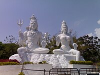
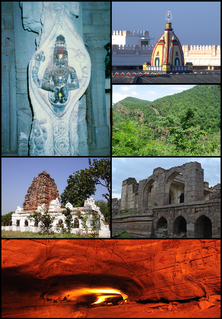
Visakhapatnam district is a district in the Indian state of Andhra Pradesh. It has numerous tourist attractions, such as the Simhachalam Temple, Kailasagiri, and the Borra Caves.
This article needs additional citations for verification .(March 2019) |
Visakhapatnam district is a district in the Indian state of Andhra Pradesh. It has numerous tourist attractions, such as the Simhachalam Temple, Kailasagiri, and the Borra Caves.

Andhra Pradesh is a state in the south-eastern coastal region of India. It is the seventh-largest state by area covering an area of 162,975 km2 (62,925 sq mi) and tenth-most populous state with 49,386,799 inhabitants. It is bordered by Telangana to the north-west, Chhattisgarh to the north, Odisha to the north-east, Tamil Nadu to the south, Karnataka to the west and the Bay of Bengal to the east. It has the second longest coastline in India after Gujarat, of about 974 km (605 mi). Andhra Pradesh is the first state to be formed on a linguistic basis in India on 1 October 1953. The state was once a major Buddhist pilgrimage site in the country and a Buddhist learning center which can be seen in many sites in the state in the form of ruins, chaityas and stupas It is also known as the land of the world-famous diamond Koh-i-Noor and many other globally known diamonds due to their source in its Kollur Mine. It is also known as the "rice bowl of India" for being a major producer of rice in India. Its official language is Telugu; one of the classical languages of India, the fourth most spoken language in India and the 11th-most spoken language in the world.

India is a federal union comprising 28 states and 8 union territories, for a total of 36 entities. The states and union territories are further subdivided into districts and smaller administrative divisions.

Coastal Andhra is a region in the state of Andhra Pradesh, India. It was part of Madras State before 1953 and Andhra State from 1953 to 1956. According to the 2011 census, it has an area of 95,442 square kilometres (36,850 sq mi) which is 57.99% of the total state area and a population of 34,193,868 which is 69.20% of Andhra Pradesh state population. This area includes the coastal districts of Andhra Pradesh on the Coromandel Coast between the Eastern Ghats and the Bay of Bengal, from the northern border with Odisha to Pulicat lake in the South.

Rayalaseema is a geographic region in the Indian state of Andhra Pradesh. It comprises four southern districts of the state namely, Anantapur, Chittoor, Kadapa and Kurnool. As of 2011 census of India, the region with four districts had a population of 15,184,908 and covers an area of 67,526 km2 (26,072 sq mi).

West Godavari district or Paschima Godavari Jilla is one of the nine districts in the Coastal Andhra region of the Indian state of Andhra Pradesh. The administrative headquarters of the district is situated at Eluru. As of 2011 census of India, the district has an area of 7,742 km2 (2,989 sq mi) and a population of 3,936,966. It is bounded by Krishna district on the west, East Godavari district on the east, Bay of Bengal on the south and the state of Telangana on the north.
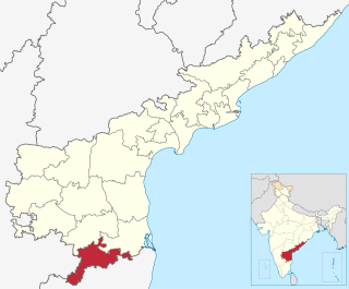
Chittoor district, is one of the four districts in the Rayalaseema region of the Indian state of Andhra Pradesh. The district headquarters is located at Chittoor. It has a population of 4,170,468 according to 2011 census of India. Chittoor district has many major temples including Tirupati, Srikalahasti, Kanipakam, and other temples. It lies in the Poini river valley of southernmost Andhra Pradesh along the Chennai – Bangalore section of Chennai-Mumbai highway. Chittoor district is a major market centre for mangoes, grains, sugarcane, and peanuts. Sricity integrated business city lies in Satyavedu mandal; it acts as a major industrial hub for Chittoor district as well as Andhra Pradesh as a whole.
Kurnool District is one of the four districts in the Rayalaseema region of the Indian state of Andhra Pradesh. The district is located in the west-central part of the state and is bounded by Mahabubnagar district of Telangana in the north, Raichur district of Karnataka in the northwest, Bellary district of Karnataka in the west, Ananthapur district in the south, YSR Kadapa district in the South East and Prakasham district in the east. The city of Kurnool is the headquarters of the district. It has a population of 4,053,463 of which 28.35% were urban as of 2011. The district is the second largest by area and seventh largest by population in the state.

Tadipatri or Tadpatri is a town in Anantapur district of the Indian state of Andhra Pradesh. It is the mandal headquarters of Tadipatri mandal in Anantapur revenue division. It is located at the border of Kurnool district and Kadapa district. The ancient world-famous Chintala Venkataramana Temple sprawling over five acre area is located in Tadipatri. From Tadipatri town at a distance of 1 kilometre, overlooking the Penna River, the Bugga Ramalingeswara Temple is located which is remarkable for a lingam seated on a pedestal that is perpetually filled with water from a small spring.
Government of Andhra Pradesh is the government for the Indian state of Andhra Pradesh. It is an elected government with 175 MLAs elected to the Legislative Assembly of Andhra Pradesh for a 5-year term. Government of Andhra Pradesh is a democratically elected body that governs the state of Andhra Pradesh, India. The state government is headed by the Governor of Andhra Pradesh as the nominal head of state, with a democratically elected Chief Minister as the real head of the executive. The governor who is appointed for five years appoints the Chief Minister and his Council of Ministers. Even though the governor remains the ceremonial head of the state, the day-to-day running of the government is taken care of by the Chief Minister and his Council of Ministers in whom a great deal of legislative powers is vested.
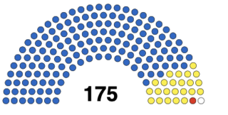
The Andhra Pradesh Legislative Assembly is the lower house of the Andhra Pradesh Legislature.

Andhra Pradesh lies between 12°41' and 19.07°N latitude and 77° and 84°40'E longitude, and is bordered by Telangana to the north and west, Chhattisgarh tk the north-west, Orissa to the north, the Bay of Bengal to the east, Tamil Nadu to the south and Karnataka to the southwest and west. Andhra Pradesh has a coastline of around 974 km, which gives it the second longest coastline in the nation. Two major rivers, the Godavari and the Krishna run across the state. A small enclave 12 sq mi (30 km²), the Yanam district of Puducherry, lies in the Godavari Delta in the north east of the state. The state includes the eastern part of Deccan plateau as well as a considerable part of the Eastern Ghats.

The Andhra Pradesh Police Department is the law enforcement agency of the state of Andhra Pradesh, India. Public order and police being a state subject in India, the police force is headed by the Director general of police, Damodar Gautam Sawang.
The Andhra Pradesh Legislative Assembly election, 2014 took place on 30 April and 7 May 2014 to elect members to the legislatures of Telangana and Andhra Pradesh. It was held concurrently with the Indian general election. The results were declared on 16 May 2014. The Telugu Desam Party led by N. Chandrababu Naidu won a majority of the 175 seats in the rump Andhra Pradesh, while Telangana Rashtra Samithi led by K. Chandrasekhar Rao won in the new state of Telangana.

Amaravati is the legislative capital and the de facto seat of government of the Indian state of Andhra Pradesh. The city is located on the banks of river Krishna in Guntur District. Built on allotted space on the southern banks of Krishna River in Guntur district selected close to the geographical center of the state.

The 2019 Andhra Pradesh Legislative Assembly elections were held in the Indian state of Andhra Pradesh on 11 April 2019 for constituting the fifteenth Legislative Assembly in the state. They were held alongside the 2019 Indian general election.

The first case of the COVID-19 pandemic in the Indian state of Andhra Pradesh was reported in Nellore on 12 March 2020. A 24-year-old who was confirmed positive for coronavirus. He had travel history to Italy. The Andhra Pradesh Health department has confirmed a total of 5,37,687 cases, including 4,702 deaths and 4,35,467 recoveries, as of 10 September. The virus has spread in 13 districts of the state, of which East Godavari has the highest number of cases.