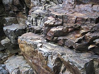
Plate tectonics is the scientific theory that Earth's lithosphere comprises a number of large tectonic plates, which have been slowly moving since 3–4 billion years ago. The model builds on the concept of continental drift, an idea developed during the first decades of the 20th century. Plate tectonics came to be accepted by geoscientists after seafloor spreading was validated in the mid-to-late 1960s. The processes that result in plates and shape Earth's crust are called tectonics. Tectonic plates also occur in other planets and moons.

Subduction is a geological process in which the oceanic lithosphere and some continental lithosphere is recycled into the Earth's mantle at the convergent boundaries between tectonic plates. Where one tectonic plate converges with a second plate, the heavier plate dives beneath the other and sinks into the mantle. A region where this process occurs is known as a subduction zone, and its surface expression is known as an arc-trench complex. The process of subduction has created most of the Earth's continental crust. Rates of subduction are typically measured in centimeters per year, with rates of convergence as high as 11 cm/year.

The Statewide California Earthquake Center (SCEC) is a collaboration of more than 1,000 scientists across 100 research institutions focused primarily on conducting research on earthquakes in Southern California and elsewhere by gathering data, conducting theoretical studies, and performing computer simulations; integrate information into a comprehensive, physics-based understanding of earthquake phenomena; and communicate that understanding to end-users and society at large as useful knowledge for reducing earthquake risk and improving community resilience.

The American Geophysical Union (AGU) is a 501(c)(3) nonprofit organization of Earth, atmospheric, ocean, hydrologic, space, and planetary scientists and enthusiasts that according to their website includes 130,000 people. AGU's activities are focused on the organization and dissemination of scientific information in the interdisciplinary and international fields within the Earth and space sciences. The geophysical sciences involve four fundamental areas: atmospheric and ocean sciences; solid-Earth sciences; hydrologic sciences; and space sciences. The organization's headquarters is located on Florida Avenue in Washington, D.C.

Oceanic crust is the uppermost layer of the oceanic portion of the tectonic plates. It is composed of the upper oceanic crust, with pillow lavas and a dike complex, and the lower oceanic crust, composed of troctolite, gabbro and ultramafic cumulates. The crust overlies the rigid uppermost layer of the mantle. The crust and the rigid upper mantle layer together constitute oceanic lithosphere.

The EarthScope project (2003-2018) was an National Science Foundation (NSF) funded Earth science program using geological and geophysical techniques to explore the structure and evolution of the North American continent and to understand the processes controlling earthquakes and volcanoes. The project had three components: USArray, the Plate Boundary Observatory, and the San Andreas Fault Observatory at Depth. Organizations associated with the project included UNAVCO, the Incorporated Research Institutions for Seismology (IRIS), Stanford University, the United States Geological Survey (USGS) and National Aeronautics and Space Administration (NASA). Several international organizations also contributed to the initiative. EarthScope data are publicly accessible.
The United Nations General Assembly declared 2008 as the International Year of Planet Earth to increase awareness of the importance of Earth sciences for the advancement of sustainable development. UNESCO was designated as the lead agency. The Year's activities spanned the three years 2006–2009.

The Northern Cordilleran Volcanic Province (NCVP), formerly known as the Stikine Volcanic Belt, is a geologic province defined by the occurrence of Miocene to Holocene volcanoes in the Pacific Northwest of North America. This belt of volcanoes extends roughly north-northwest from northwestern British Columbia and the Alaska Panhandle through Yukon to the Southeast Fairbanks Census Area of far eastern Alaska, in a corridor hundreds of kilometres wide. It is the most recently defined volcanic province in the Western Cordillera. It has formed due to extensional cracking of the North American continent—similar to other on-land extensional volcanic zones, including the Basin and Range Province and the East African Rift. Although taking its name from the Western Cordillera, this term is a geologic grouping rather than a geographic one. The southmost part of the NCVP has more, and larger, volcanoes than does the rest of the NCVP; further north it is less clearly delineated, describing a large arch that sways westward through central Yukon.
Ronald M. Clowes, CM is a professor specializing in seismic and other geophysical studies of the Earth's lithosphere. For his work he has been appointed a member of the Order of Canada.
James (Jim) W.H. Monger is an emeritus scientist of the Geological Survey of Canada and a world leader in the application of plate tectonics to the study of mountain chain formation.

Marcia Kemper McNutt is an American geophysicist and the 22nd president of the National Academy of Sciences (NAS) of the United States.
Richard Lee Armstrong was an American-Canadian scientist who was an expert in the fields of radiogenic isotope geochemistry and geochronology, geochemical evolution of the earth, geology of the American Cordillera, and large-magnitude crustal extension. He published over 170 scientific papers.
James Anthony Jackson CBE FRS is Emeritus Professor of Active Tectonics and formerly head of Bullard Laboratories, and Head of the Department of Earth Sciences, Cambridge University. He made his name in geophysics, using earthquake source seismology to examine how continents are deformed. His central research focus is to observe the active processes shaping our continents.

Earth science or geoscience includes all fields of natural science related to the planet Earth. This is a branch of science dealing with the physical, chemical, and biological complex constitutions and synergistic linkages of Earth's four spheres: the biosphere, hydrosphere/cryosphere, atmosphere, and geosphere. Earth science can be considered to be a branch of planetary science but with a much older history.
Mary Lou Zoback is an American geophysicist and seismologist. A specialist in tectonic stress and natural hazards risks, she spent most of her career as a research scientist with the United States Geological Survey. Zoback chaired the World Stress Map project of the International Lithosphere Program from 1986 to 1992. Zoback served on the U.S. Nuclear Waste Technical Review Board from 2012 to 2018.
Charlotte E. Keen is a Canadian geologist and professor emeritus at the Geological Survey of Canada. Her work focuses on the structure of the Earth's crust and the upper mantle using geophysical imaging and magnetic measurements. She was the first woman to go on a Canadian Survey Ship.
The Stanford Doerr School of Sustainability is a school at Stanford University focusing on climate change and sustainability. The school also researches many domains of fossil fuel extraction and development. It opened on September 1, 2022, as Stanford's first new school since the School of Humanities and Sciences in 1948. It is considered one of the largest climate change–related schools in the United States.

Irina M. Artemieva is Professor of Geophysics at the GEOMAR Helmholtz Centre for Ocean Research in Kiel (Germany) and distinguished professor at the China University of Geosciences (Wuhan) and at SinoProbe at the Chinese Academy of Geological Sciences (Beijing).
John Nicholas Ludden CBE FRSE is a British geologist, with expertise in igneous petrology and geochemistry. He was the 19th director of the British Geological Survey from 2006 to 2019, and has been president of the European Geosciences Union and the International Union of Geological Sciences.


