In geology, a terrane is a crust fragment formed on a tectonic plate and accreted or "sutured" to crust lying on another plate. The crustal block or fragment preserves its own distinctive geologic history, which is different from that of the surrounding areas—hence the term "exotic" terrane. The suture zone between a terrane and the crust it attaches to is usually identifiable as a fault. A sedimentary deposit that buries the contact of the terrane with adjacent rock is called an overlap formation. An igneous intrusion that has intruded and obscured the contact of a terrane with adjacent rock is called a stitching pluton.

The Antler orogeny was a tectonic event that began in the early Late Devonian with widespread effects continuing into the Mississippian and early Pennsylvanian. Most of the evidence for this event is in Nevada but the limits of its reach are unknown. A great volume of conglomeratic deposits of mainly Mississippian age in Nevada and adjacent areas testifies to the existence of an important tectonic event, and implies nearby areas of uplift and erosion, but the nature and cause of that event are uncertain and in dispute. Although it is known as an orogeny, some of the classic features of orogeny as commonly defined such as metamorphism, and granitic intrusives have not been linked to it. In spite of this, the event is universally designated as an orogeny and that practice is continued here. This article outlines what is known and unknown about the Antler orogeny and describes three current theories regarding its nature and origin.

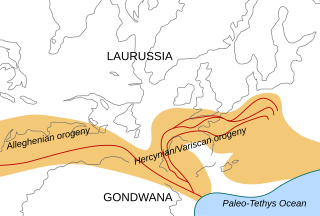
The Variscan or Hercynianorogeny was a geologic mountain-building event caused by Late Paleozoic continental collision between Euramerica (Laurussia) and Gondwana to form the supercontinent of Pangaea.
The Lewis Overthrust is a geologic thrust fault structure of the Rocky Mountains found within the bordering national parks of Glacier in Montana, United States and Waterton Lakes in Alberta, Canada. The structure was created due to the collision of tectonic plates about 59-75 million years ago that drove a several mile thick wedge of Precambrian rock 50 mi (80 km) eastwards, causing it to overlie softer Cretaceous age rock that is 1300 to 1400 million years younger.

The Northern Cordilleran Volcanic Province (NCVP), formerly known as the Stikine Volcanic Belt, is a geologic province defined by the occurrence of Miocene to Holocene volcanoes in the Pacific Northwest of North America. This belt of volcanoes extends roughly north-northwest from northwestern British Columbia and the Alaska Panhandle through Yukon to the Southeast Fairbanks Census Area of far eastern Alaska, in a corridor hundreds of kilometres wide. It is the most recently defined volcanic province in the Western Cordillera. It has formed due to extensional cracking of the North American continent—similar to other on-land extensional volcanic zones, including the Basin and Range Province and the East African Rift. Although taking its name from the Western Cordillera, this term is a geologic grouping rather than a geographic one. The southmost part of the NCVP has more, and larger, volcanoes than does the rest of the NCVP; further north it is less clearly delineated, describing a large arch that sways westward through central Yukon.
The Geological Association of Canada (GAC) is a learned society that promotes and develops the geological sciences in Canada. The organization holds conferences, meetings and exhibitions for the discussion of geological problems and the exchange of views in matters related to geology. It publishes various journals and collections of learned papers dealing with geology.

Raymond Alexander Price, is a Canadian geologist. He has used his research on the structure and tectonics of North America’s lithosphere to produce extensive geological maps. He has also provided guidance for nuclear fuel waste disposal and reports on the human contribution to Global warming.
John Oliver Wheeler was a Canadian geologist, who spent most of his career as a research scientist with the Geological Survey of Canada.
Richard Lee Armstrong was an American/Canadian scientist who was an expert in the fields of radiogenic isotope geochemistry and geochronology, geochemical evolution of the earth, geology of the American Cordillera, and large-magnitude crustal extension. He published over 170 scientific papers.

A volcanic belt is a large volcanically active region. Other terms are used for smaller areas of activity, such as volcanic fields. Volcanic belts are found above zones of unusually high temperature where magma is created by partial melting of solid material in the Earth's crust and upper mantle. These areas usually form along tectonic plate boundaries at depths of 10 to 50 kilometres. For example, volcanoes in Mexico and western North America are mostly in volcanic belts, such as the Trans-Mexican Volcanic Belt that extends 900 kilometres (560 mi) from west to east across central-southern Mexico and the Northern Cordilleran Volcanic Province in western Canada.

John Joseph Clague PhD FRSC OC is a Canadian authority in Quaternary and environmental earth sciences. He is a professor of earth sciences at Simon Fraser University and an emeritus scientist of the Geological Survey of Canada.

The geology of British Columbia is a function of its location on the leading edge of the North American continent. The mountainous physiography and the diversity of the different types and ages of rock hint at the complex geology, which is still undergoing revision despite a century of exploration and mapping.

Stikinia, or the Stikine terrane, is a terrane in British Columbia, Canada; the largest of the Canadian Cordillera. It formed as an independent, intraoceanic volcanic arc during the Paleozoic and Mesozoic.

Peter Alfred Ziegler was a Swiss geologist, who made contributions to the understanding of the geological evolution of Europe and the North Atlantic borderlands, of intraplate tectonics and of plate tectonic controls on the evolution and hydrocarbon potential of sedimentary basins. Ziegler's career consists of 33 years as exploration geologist with the petroleum industry, 30 of which with Shell, and 20 years of university teaching and research.
Jack Gordon Souther was an American-born Canadian geologist, volcanologist, professor and engineer. He contributed significantly to the early understanding of recent volcanic activity in the Canadian Cordillera. Many of his publications continue to be regarded as classics in their field, even now several decades after they were written.

The geology of Bolivia comprises a variety of different lithologies as well as tectonic and sedimentary environments. On a synoptic scale, geological units coincide with topographical units. The country is divided into a mountainous western area affected by the subduction processes in the Pacific and an eastern lowlands of stable platforms and shields. The Bolivian Andes is divided into three main ranges; these are from west to east: the Cordillera Occidental that makes up the border to Chile and host several active volcanoes and geothermal areas, Cordillera Central once extensively mined for silver and tin and the relatively low Cordillera Oriental that rather than being a range by its own is the eastern continuation of the Central Cordillera as a fold and thrust belt. Between the Occidental and Central Cordillera the approximately 3,750-meter-high Altiplano high plateau extends. This basin hosts several freshwater lakes, including Lake Titicaca as well as salt-covered dry lakes that bring testimony of past climate changes and lake cycles. The eastern lowlands and sub-Andean zone in Santa Cruz, Chuquisaca, and Tarija Departments was once an old Paleozoic sedimentary basin that hosts valuable hydrocarbon reserves. Further east close to the border with Brazil lies the Guaporé Shield, made up of stable Precambrian crystalline rock.

The geology of North America is a subject of regional geology and covers the North American continent, the third-largest in the world. Geologic units and processes are investigated on a large scale to reach a synthesized picture of the geological development of the continent.
The Superior Craton is a stable crustal block covering Quebec, Ontario, and southeast Manitoba in Canada, and northern Minnesota in the United States. It is the biggest craton among those formed during the Archean period. A craton is a large part of the Earth's crust that has been stable and subjected to very little geological changes over a long time. The size of Superior Craton is about 1,572,000 km2. The craton underwent a series of events from 4.3 to 2.57 Ga. These events included the growth, drifting and deformation of both oceanic and continental crusts.


