Fitjar is a municipality in Hordaland county, Norway. The municipality is located in the traditional district of Sunnhordland. Fitjar municipality includes the northern part of the island of Stord and the hundreds of surrounding islands, mostly to the northwest of the main island. The administrative centre of the municipality is the village of Fitjar.
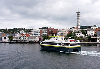
Leirvik is a town and the administrative centre of Stord municipality in Hordaland county, Norway. The town lies along the southern coast of the large island of Stord, along the Hardangerfjorden. The town gained "town status" in 1997. The town includes the Eldøyane peninsula where the large Kværner Stord industrial area is located.

Husavik is a village in Austevoll municipality in Hordaland county, Norway. The village is located on Vestre Vinnesvåg area on the southeastern shore of the island of Huftarøy, about 1 kilometre (0.62 mi) northeast of the village of Vinnes and about 2 kilometres (1.2 mi) south of the farming village of Otterå. The village is a regular stop for a ferry service connecting the islands of Austevoll to the large island of Stord to the south, across the Selbjørnsfjorden. The village was one of the first villages in Austevoll to gain industrial jobs. An engine factory was built here in 1910.

The Hardangerfjord is the fourth longest fjord in the world, and the second longest fjord in Norway. It is located in Hordaland county in the Hardanger region. The fjord stretches 179 kilometres (111 mi) from the Atlantic Ocean into the mountainous interior of Norway along the Hardangervidda plateau. The innermost point of the fjord reaches the town of Odda.
Sunnhordland is a traditional district in the Vestlandet region of Norway. The district consists of the southern coastal regions of Hordaland county. In includes the areas that surround the mouth of the Hardangerfjorden and the surrounding islands. The municipalities of Sveio, Etne, Stord, Bømlo, Fitjar, Kvinnherad, and Tysnes make up the district of Sunnhordaland. The regional centre of this district is the town of Leirvik in Stord.

The Norwegian vintage steamship SS Stord I was built as Stord in 1913 and delivered from Laxevaag Maskin- og Jernskipsbyggeri in Bergen, Norway to Hardanger Sunnhordlandske Dampskipsselskap (HSD).
Storebø is the administrative centre and largest village in Austevoll municipality in Hordaland county, Norway. The village is located on the northern part of the island of Huftarøy, just south of the village of Birkeland and northwest of the village of Haukanes. The 1.61-square-kilometre (400-acre) village has a population (2016) of 1,377; giving the village a population density of 855 inhabitants per square kilometre (2,210/sq mi).
Sagvåg is a village in Stord municipality in Hordaland county, Norway. The village is located on the southwest coast of the island of Stord, about 5 kilometres (3.1 mi) west of the town of Leirvik. The Stord Airport, Sørstokken lies about 2 kilometres (1.2 mi) northwest of Sagvåg. Nysæter Church was built here in 1991 to serve the population of the village. The small mining village of Litlabø lies just northeast of Sagvåg.
Grov is a village in Stord municipality in Hordaland county, Norway. The village is located on the island of Stord, about a 7-minute drive north of the town of Leirvik. Grov lies along the European route E39 highway and the Langenuen strait, overlooking the island of Huglo across the strait. Grov is known for its fantastic natural surroundings and peaceful life by the sea.
Nils Andreas Økland was a Norwegian Esperantist and teacher in Stord (Hordaland), Norway. He spent some years in his youth on the island Utsira, where his father was a school teacher. Nils Økland was married to Hanna Olava Bergstøl, and they had 3 sons. His father Matthias Larsen Økland was also a school teacher and a church chorister; his mother was Signi Nilsdatter from Eidsvåg. Having learned Esperanto indirectly through his friend Haldor Midthus by 1904, he served as president on the executive council of Stord's Norwegian Esperanto League branch.
Hordfast or the Hordaland Fixed Link is a planned road project between the mainland city of Bergen and the island of Stord in Hordaland county, Norway. Hordfast is the colloquial name for the project since it will connect the islands of Hordaland county with the fastlandet.

Mehammarsåta or Midhamarsåta is the highest mountain on the island of Stord in the municipality of Stord in Hordaland county, Norway. The 749-metre (2,457 ft) tall mountain lies in the northeastern part of the municipality, just south of the municipal border with Fitjar.
Operation Cartoon was a British Commando raid on the island of Stord near Leirvik in Hordaland, Norway on the night of 23/24 January 1943. The operation was carried out by 53 men of No. 12 Commando supported by ten men from the Norwegian 10 (IA) Commando. RAF Coastal Command co-operated with the Commandos, with aircraft from 18 Group.
Stokksundet is a sound between the islands of Stord and Bømlo in Hordaland county, Norway. It is about 15 kilometres (9.3 mi) long and it runs from the village of Koløyhamn in the north to the islands of Føyno, Nautøya, and Spyssøya in the south. The Digernessundet is a small strait on the south end that connects the Stokksundet to the vast Hardangerfjorden. On the southern end of the strait, the Stord Bridge and Bømla Bridge cross the sound, connecting the islands of Stord and Bømlo to the Bømlafjord Tunnel as part of the Triangle Link which connects both islands to the mainland.

Stordø Kisgruber was a Norwegian mining company which operated the pyrite mines in Litlabø at Stord in Hordaland, Norway.
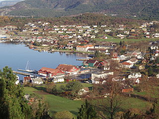
Fitjar (help·info) is the administrative centre of Fitjar municipality in Hordaland county, Norway. The village is located on the northwestern shore of the island of Stord. It sits at the southern end of the Fitjarvika bay, a small arm off the main Selbjørnsfjorden. A large group of small islands lie just off the coast to the west. The 1.33-square-kilometre (330-acre) village has a population (2013) of 1,472 which gives it a population density of 1,107 inhabitants per square kilometre (2,870/sq mi). Fitjar Church is located in this central part of this village. The historic Battle of Fitjar took place in this area in the year 961.

Stord Church is a parish church in Stord municipality in Hordaland county, Norway. It is located in the town of Leirvik on the southern side of the island of Stord. The church is part of the Stord parish in the Sunnhordland deanery in the Diocese of Bjørgvin. The white, stone church was built in 1857 and it seats about 530 people.

Nysæter Church is a parish church in Stord municipality in Hordaland county, Norway. It is located in the village of Sagvåg on the southwestern coast of the island of Stord. The church is part of the Nysæter parish in the Sunnhordland deanery in the Diocese of Bjørgvin. The brick church was built in 1991 by the architect Colin Ansbach. The church, which seats about 350 people, was consecrated in January 1992. The sanctuary has a fan-shaped design.


