Stordø Kisgruber

Last updated
The elevator tower at Stordo Kisgruber at Litlabo, Stord Stordo Kisgruber2.JPG
The elevator tower at Stordø Kisgruber at Litlabø, Stord

Stordø Kisgruber was a Norwegian mining company which operated the pyrite mines in Litlabø at Stord in Hordaland, Norway. [1]

Pyrite sulfide mineral

The mineral pyrite, or iron pyrite, also known as fool's gold, is an iron sulfide with the chemical formula FeS2 (iron(II) disulfide). Pyrite is considered the most common of the sulfide minerals.

Litlabø Village in Western Norway, Norway

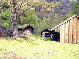
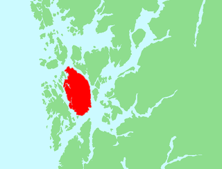
Litlabø is a village and former mining community in the municipality of Stord in Hordaland county, Norway. It is located at the northern side of the lake of Storavatnet, just northeast of the village of Sagvåg. The village had about 450 inhabitants as of 2001. Litlabø was the location for the pyrite mines of Stordø Kisgruber, which operated from 1907 to 1968.

Stord Municipality in Hordaland, Norway

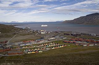
Stord is a municipality in Hordaland county, Norway. It is located in the traditional district of Sunnhordland. Stord is sometimes called "Norway in miniature" since it has such a variety of landscapes: coastline, fjords, forests, agricultural land, and mountain areas. The administrative centre of the municipality is the town of Leirvik, which is also the largest town in the municipality and the whole region of Sunnhordland. Leirvik was declared a town in 1997. Other population centres in the municipality include the large village of Sagvåg and the smaller villages of Litlabø and Grov.

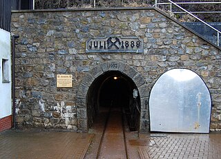
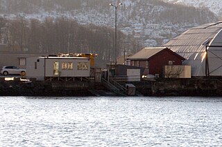
Mining for pyrite at Litlabø had first been estgablished in 1865. Stordø Kisgruber A/S was established in 1907 and maintained mining operations which ended in 1968. A total of about eight million tons of ore was won during the operation of the mine. Under the elevator tower is the main mine shaft which went straight down about 750 meters deep. Altogether there are 80 km of shafts into the mountain. A railway line operated between Litlabø and the quays at Sagvåg. [2] [3]

Sagvåg Village in Western Norway, Norway

Sagvåg is a village in Stord municipality in Hordaland county, Norway. The village is located on the southwest coast of the island of Stord, about 5 kilometres (3.1 mi) west of the town of Leirvik. The Stord Airport, Sørstokken lies about 2 kilometres (1.2 mi) northwest of Sagvåg. Nysæter Church was built here in 1991 to serve the population of the village. The small mining village of Litlabø lies just northeast of Sagvåg.

During the Nazi occupation of Norway, the mines delivered pyrite to Germany for use by the country's war industry. During 1941, this amounted to 9,000 tons per month. In January 1943 the mines were targeted by the British Commando raid Operation Cartoon. Several dynamite charges were set off in various buildings at Litlabø. The hoist machine, the compressor house and the locomotive engine shed, among others, were blown up. [4]

Operation Cartoon

Operation Cartoon was a British Commando raid on the island of Stord near Leirvik in Hordaland, Norway on the night of 23/24 January 1943. The operation was carried out by 53 men of No. 12 Commando supported by ten men from the Norwegian 10 (IA) Commando. RAF Coastal Command co-operated with the Commandos, with aircraft from 18 Group.

The Mining Museum at Litlabø (Norwegian : Gruvemuseet på Litlabø) was later established to commemorate the mines and the accompanying society. [5] [6]

Norwegian language North Germanic language spoken in Norway

Norwegian is a North Germanic language spoken mainly in Norway, where it is the official language. Along with Swedish and Danish, Norwegian forms a dialect continuum of more or less mutually intelligible local and regional varieties, and some Norwegian and Swedish dialects, in particular, are very close. These Scandinavian languages, together with Faroese and Icelandic as well as some extinct languages, constitute the North Germanic languages. Faroese and Icelandic are hardly mutually intelligible with Norwegian in their spoken form because continental Scandinavian has diverged from them. While the two Germanic languages with the greatest numbers of speakers, English and German, have close similarities with Norwegian, neither is mutually intelligible with it. Norwegian is a descendant of Old Norse, the common language of the Germanic peoples living in Scandinavia during the Viking Era.

Coordinates: 59°47′30″N5°24′00″E / 59.79167°N 5.40000°E / 59.79167; 5.40000

Geographic coordinate system Coordinate system

A geographic coordinate system is a coordinate system that enables every location on Earth to be specified by a set of numbers, letters or symbols. The coordinates are often chosen such that one of the numbers represents a vertical position and two or three of the numbers represent a horizontal position; alternatively, a geographic position may be expressed in a combined three-dimensional Cartesian vector. A common choice of coordinates is latitude, longitude and elevation. To specify a location on a plane requires a map projection.

Related Research Articles

Evje og Hornnes Municipality in Aust-Agder, Norway

Evje og Hornnes is a municipality in Aust-Agder county, Norway. It is located in the traditional district of Setesdal. The administrative centre of the municipality is the village of Evje. Other villages in the municipality include Åneland, Dåsnesmoen, Flatebygd, Gautestad, Hornnes, Kjetså, and Øvre Dåsvatn. Evje og Hornnes was created as a new municipality on 1 January 1960 after the merger of the two older municipalities of Evje and Hornnes. The Norwegian National Road 9 runs north-south through the municipality, along the river Otra.

Longyearbyen Place in Svalbard, Norway

Longyearbyen (Norwegian pronunciation: [ˈlɔŋjiːrbyːən] is the largest settlement and the administrative centre of Svalbard, Norway. As of December 2015, the town had a population of 2,144. Longyearbyen is located in the Longyear Valley and on the shore of Adventfjorden, a bay of Isfjorden located on the west coast of Spitsbergen. Since 2002, Longyearbyen Community Council has had many of the same responsibilities of a municipality, including utilities, education, cultural facilities, fire brigade, roads and ports. The town is the seat of the Governor of Svalbard. It is the world's northernmost settlement of any kind with more than 1,000 permanent residents.

Ny-Ålesund Research town in Svalbard, Norway

Ny-Ålesund is a research town in Oscar II Land on the island of Spitsbergen in Svalbard, Norway. It is situated on the Brøgger peninsula (Brøggerhalvøya) and on the shore of the bay of Kongsfjorden. The company town is owned and operated by Kings Bay, who provide facilities for permanent research institutes from ten countries. The town is ultimately owned by the Ministry of Trade and Industry and is not incorporated. Ny-Ålesund has an all-year permanent population of 30 to 35, with the summer population reaching 120. Its facilities include Ny-Ålesund Airport, Hamnerabben, Svalbard Rocket Range, a port and Ny-Ålesund Town and Mine Museum, as well as fifteen permanent research stations. It is the northernmost functional civilian settlement in the world.

Ofoten Line railway line in Narvik, Norway

The Ofoten Line is a 43-kilometre (27 mi) railway line in Narvik, Norway. It runs from the Port of Narvik to Riksgränsen on the Norway–Sweden border, where the line continues as the Ore Line via Kiruna and Gällivare to Luleå. The Ofoten Line is single track, electrified at 15 kV 16.7 Hz AC and has seven stations. The line only connects to the rest of the Norwegian railway network via Sweden. The main traffic is up to twelve daily freight trains operated by Malmtrafik that haul iron ore from Sweden to Narvik. In addition, CargoNet operates container trains, branded as the Arctic Rail Express (ARE), and SJ operates passenger trains, including a night train to Stockholm.

Svea Airport airport in the Svalbard, Norwegian overseas territory

Svea Airport is a private airport located in and serving the Sveagruva in Svalbard, Norway. The airport is owned and operated by Store Norske Spitsbergen Kulkompani, who use the airport to transport their coal mining workers from the company town to Longyearbyen and Svalbard Airport, Longyear. The airport features a gravel runway measuring 800 by 30 meters. Flights are operated about thirty times per week by Lufttransport using their two Dornier Do 228.

Store Norske Spitsbergen Kulkompani Norwegian coal mining company

Store Norske Spitsbergen Kulkompani (SNSK), or simply Store Norske, is a Norwegian coal mining company based on the Svalbard archipelago. It was formed in 1916, after a Norwegian purchase of the American Arctic Coal Company (ACC).

Kirkenes–Bjørnevatn Line railway line

The Kirkenes–Bjørnevatn Line, or the Sydvaranger Line, is a 8.5-kilometer (5.3 mi) long railway line between Kirkenes and Bjørnevatn in Sør-Varanger, Norway. Owned by the private mining company Northern Iron, the single-track railway is solely used to haul 20 daily iron ore trains from Bjørnevatn Mine to the port at Kirkenes. It was the world's northern-most railway until 2010, when the Obskaya–Bovanenkovo Line in Russia went further north.

Dunderland Line former railway line in Rana, Norway

The Dunderland Line was a 23.7 km (14.7 mi) railway line between Gullsmedvik in the town of Mo i Rana and the village of Storforshei in Rana Municipality in Nordland county, Norway. Since 1942 the line has been part of the Nordland Line. The line was originally built and owned by Dunderland Iron Ore Company, which used it to freight iron ore from their mine at Storforshei to the port at Gullsmedvik.

Pyhäsalmi Mine mine in Pyhäjärvi, Finland

Pyhäsalmi Mine, the deepest base metal mine in Europe is located at the Pyhäjärvi municipality in the south of Oulu province, Finland. The zinc and copper mine is owned by First Quantum Minerals, a Canadian mining corporation.

Davis, Massachusetts is the abandoned location of the Davis Pyrite Mine. located in the town of Rowe, Massachusetts. Once the largest iron pyrite-mine in Massachusetts, Davis grew to be a decent sized mining village at the beginnings of the Second Industrial Revolution (1870–1915). But, in 1911, a non-fatal collapse of the mine due to “poor mining practices” ended the nearly 30-year run. By 1937, the mining camp had faded, and all that remained were a blacksmith shop and about 150 cellar holes.

Løkken Mine

The Løkken Mine is an underground pyrite mine located in the municipality of Meldal in Sør-Trøndelag, Norway. The mine was operative from 1654 to 1987, from the mining community Løkken Verk. It contained the largest deposits of its kind in Norway. Between 1654 and 1845, a total of 11,300 tons of copper was produced from the mine. From 1904 the mine was run by the company Orkla Grube-Aktiebolag, and until 1987 a total of 24 million tons of pyrite was produced from the mine. In addition to sulphur, the pyrite contained about 2% copper, in addition to zinc and traces of silver and gold. The products were originally transported to the sea by horse and sledge during winter time. From 1908 the ore was transported by the Thamshavn Line, which was the first electrical railway line in Norway. The annual production was about 350,000 tons of ore during its final years.

Orkla Mining Company

Orkla Mining Company Ltd. was a Norwegian mining company established in 1904. The company was the largest mining company in Norway in the aftermath of World War I, and was among the world's largest pyrite producers. After closing of the mining operations in 1987, the company developed into the holding company Orkla ASA, which is among the largest companies at Oslo Stock Exchange.

MTB 345 was an experimental motor torpedo boat constructed in 1941, which saw limited service with the Royal Navy before being transferred to the exiled Royal Norwegian Navy on 16 March 1943. She sailed with the Royal Norwegian Navy for three months in 1943, until captured by German forces on 28 July 1943, during her second mission to the coast of occupied Norway. Two days after their capture, the crew of MTB 345 were executed by the Germans based on Hitler's Commando Order. Following their capture of MTB 345, the Germans pressed the motor torpedo boat into Kriegsmarine service, renaming her SA 7. SA 7 was lost in a fire in the North Sea in August 1943.

Drei Kronen & Ehrt Mine in Germany

Drei Kronen & Ehrt is a former mine in the Harz Mountains of central Germany. It is located in the parish of Elbingerode in the county of Harz (Saxony-Anhalt). The mine extracted pyrite. Since 1992 it has been used, albeit not continuously, as a visitor mine.

Rolf Hauge was a Norwegian army officer with the rank of colonel. Having participated in the 1940 Norwegian Campaign, opposing the German invasion of Norway, he later served with the Norwegian Armed Forces in exile, commanding No. 5 Norwegian Troop of the No. 10 (Inter-Allied) Commando.

Haugesund Airport, Storesundsskjær

Haugesund Airport, Storesundsskjær was a water aerodrome which served Haugesund, Norway, from 1936 to 1956. The airport consisted of a barge anchored at Midtre Storesundsskjær in Haugesund's port. Affixed was a floating dock and a terminal building.

Bergen Airport, Sandviken

Bergen Airport, Sandviken is a water airport and heliport situated in the Sandviken neighborhood of Bergen, Norway. The aerodrome is located on the artificial peninsula of Kristiansholm. It is currently serving seaplanes and helicopters operated by Fonnafly aimed at air taxi services at cruise ship tourists. The airport is owned by Bergen Municipality through Bergen Port Authority and is part of the Bergen Port. Operations are carried out by Fonnafly.

Sulitjelma Mines mining company in Fauske, Norway

Sulitjelma Mines was a Norwegian mining company that extracted copper, pyrite, and zinc at Sulitjelma in the municipality of Fauske, Norway. Operations started with a test mine in 1887. From 1891 to 1933, the business was registered as a Swedish company called Sulitelma Aktiebolags Gruber. From 1933 to 1983, it was registered as a Norwegian company called A/S Sulitjelma Gruber, and from 1983 until it was shut down in 1991 the company was state-owned and was named Sulitjelma Bergverk AS.

References

  1. Frå soga om gruvene på Litlabø (gruo.no)
  2. Godal, Anne Marit (ed.). "Stordø Kisgruver". Store norske leksikon (in Norwegian). Norsk nettleksikon. Retrieved 21 April 2014.
  3. From the History of the Litlabø Mines (Written by Per Ivar Tautra, English translation by Sigmund Grønsdal)
  4. Haga, Arnfinn (1984). Klar til storm. Med de norske commandos i annen verdenskrig (in Norwegian). Cappelen. pp. 47–69. ISBN   82-02-09088-1.
  5. Lauritzen, Per Roger, ed. (2013). NAF Veibok 2014-2016 (in Norwegian) (30 ed.). Oslo: Norges Automobil-Forbund. p. 244. ISBN   978-82-7167-124-2.
  6. Gruvemuseet på Litlabø. Til minne om Stordø Kisgruber (gruo.no)