Little Auglaize River

Last updated
Map of the Maumee River watershed showing the Little Auglaize River. Maumeerivermap.png
Map of the Maumee River watershed showing the Little Auglaize River.

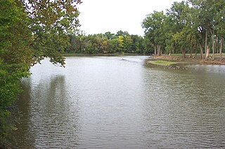
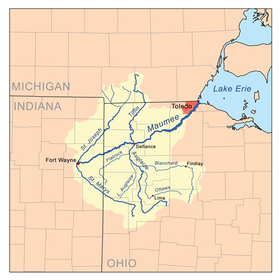
The Little Auglaize River is a 47.0-mile-long (75.6 km) [1] tributary of the Auglaize River in northwest Ohio in the United States. It drains a primarily rural farming area in the watershed of Lake Erie.

Auglaize River river in the United States of America

The Auglaize River is a 113-mile-long (182 km) tributary of the Maumee River in northwestern Ohio in the United States. It drains a primarily rural farming area in the watershed of Lake Erie. The name of the river comes from the French word for glaise (clay). The French called it "rivière à la Grande Glaize".

Ohio State of the United States of America

Ohio is a Midwestern state in the Great Lakes region of the United States. Of the fifty states, it is the 34th largest by area, the seventh most populous, and the tenth most densely populated. The state's capital and largest city is Columbus.

United States Federal republic in North America

The United States of America (USA), commonly known as the United States or America, is a country comprising 50 states, a federal district, five major self-governing territories, and various possessions. At 3.8 million square miles, the United States is the world's third or fourth largest country by total area and is slightly smaller than the entire continent of Europe's 3.9 million square miles. With a population of over 327 million people, the U.S. is the third most populous country. The capital is Washington, D.C., and the largest city by population is New York City. Forty-eight states and the capital's federal district are contiguous in North America between Canada and Mexico. The State of Alaska is in the northwest corner of North America, bordered by Canada to the east and across the Bering Strait from Russia to the west. The State of Hawaii is an archipelago in the mid-Pacific Ocean. The U.S. territories are scattered about the Pacific Ocean and the Caribbean Sea, stretching across nine official time zones. The extremely diverse geography, climate, and wildlife of the United States make it one of the world's 17 megadiverse countries.

It rises in southern Van Wert County, approximately 10 miles (16 km) south of Van Wert. It flows northeast past Middle Point. Near Ottoville in western Putnam County it turns north-northwest for its lower 10 miles (16 km) and joins the Auglaize from the south near Melrose in eastern Paulding County.

Van Wert County, Ohio County in the United States

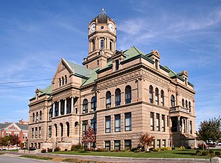
Van Wert County is a county located in the U.S. state of Ohio. As of the 2010 census, the population was 28,744. Its county seat is Van Wert. The county was created in 1820 and later organized in 1837. It is named for Isaac Van Wart, one of the captors of John André in the American Revolutionary War.

Van Wert, Ohio City in Ohio, United States

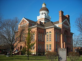
Van Wert is a city in and the county seat of Van Wert County, Ohio, United States. The municipality is located in northwestern Ohio approximately 77 mi (123 km) SW of Toledo and 34 mi (54 km) SE of Fort Wayne, Indiana. The population was 10,846 at the 2010 census. It is the principal city of and is included in the Van Wert Micropolitan Statistical Area, which is included in the Lima-Van Wert- Wapakoneta, Ohio Combined Statistical Area. Van Wert is named for Isaac Van Wart, one of the captors of Major John André in the American Revolutionary War. A center of peony cultivation, Van Wert has hosted the annual Van Wert Peony Festival on and off since 1902. Van Wert is home to the first county library in the United States, the Brumback Library. It also has a thriving community art center the Wassenburg Art Center and the award-winning Van Wert Civic Theatre. The home office of Central Insurance Companies is located in Van Wert.

Middle Point, Ohio Village in Ohio, United States

Middle Point is a village in Van Wert County, Ohio, United States. The population was 576 at the 2010 census. It is included within the Van Wert, Ohio Micropolitan Statistical Area.

See also

Related Research Articles

Paulding County, Ohio County in the United States

Paulding County is a county located in the U.S. state of Ohio. As of the 2010 census, the population was 19,614. Its county seat is Paulding. The county was created in 1820 and later organized in 1839. It is named for John Paulding, one of the captors of Major John André in the American Revolutionary War.

Auglaize County, Ohio County in the United States

Auglaize County is a county located in the U.S. state of Ohio. As of the 2010 census, the population was 45,949. Its county seat is Wapakoneta.

Allen County, Ohio County in the United States

Allen County is a county in the U.S. state of Ohio. As of the 2010 census, the population was 106,331. The county seat is Lima. The county was created in 1820 and organized in 1831. The county is named for Colonel John Allen, who was killed leading his men at the Battle of Frenchtown, during the War of 1812. It has also been claimed the county was named for Revolutionary War soldier Ethan Allen, but the weight of the evidence in favor of John Allen led the General Assembly to declare in 1976 that the county was named for him.

New Knoxville, Ohio Village in Ohio, United States

New Knoxville is a village in Auglaize County, Ohio, United States. It was established in 1836. The population was 879 at the 2010 census. It is included in the Wapakoneta, Ohio Micropolitan Statistical Area.

Great Black Swamp

The Great Black Swamp, was a glacially fed wetland in northwest Ohio and extreme northeast Indiana, United States, that existed from the end of the Wisconsin glaciation until the late 19th century. Comprising extensive swamps and marshes, with some higher, drier ground interspersed, it occupied what was formerly the southwestern part of proglacial Lake Maumee, a holocene precursor to Lake Erie. The area was about 25 miles (40 km) wide and 100 miles (160 km) long, covering an estimated 1,500 square miles (4,000 km2). Gradually drained and settled in the second half of the 19th century, it is now highly productive farm land.

Ottawa River (Auglaize River tributary) river in the United States of America

The Ottawa River is a tributary of the Auglaize River, approximately 50 miles (80 km) long, in northwestern Ohio in the United States. The river is named for the Ottawa tribe of Native Americans who inhabited the area in the 18th century. It shares its name with another river in northwestern Ohio, the Ottawa River in Toledo, as well as the Ottawa river in Ontario & Quebec Canada.

Blanchard River river in the United States of America

The Blanchard River is a 103-mile-long (166 km) tributary of the Auglaize River in northwestern Ohio in the United States. It drains a primarily rural farming area in the watershed of Lake Erie.

Flatrock Creek is a 57.2-mile-long (92.1 km) tributary of the Auglaize River in northeastern Indiana and northwestern Ohio in the United States. It drains a primarily rural farming area in the watershed of Lake Erie.

Salem Township, Auglaize County, Ohio Township in Ohio, United States

Salem Township is one of the fourteen townships of Auglaize County, Ohio, United States. The 2010 census found 498 people in the township.

Saint Marys Township, Auglaize County, Ohio township of Ohio

Saint Marys Township is one of the fourteen townships of Auglaize County, Ohio, United States. The 2010 census found 11,015 people in the township.

Jennings Township, Van Wert County, Ohio Township in Ohio, United States

Jennings Township is one of the twelve townships of Van Wert County, Ohio, United States. The 2000 census found 695 people in the township, 623 of whom lived in the unincorporated portions of the township.

Lima–Van Wert–Wapakoneta, OH, combined statistical area

The Lima–Van Wert–Wapakoneta Combined Statistical Area (CSA) is made up of three counties in Northwest Ohio. The Lima Metropolitan Statistical Area and two Micropolitan Statistical Areas – Van Wert and Wapakoneta, are components of the CSA. As of the 2000 Census, the CSA had a population of 184,743.

South and East of the First Principal Meridian

South and East of the First Principal Meridian is a land description in the American Midwest.

Glenmore, Ohio human settlement in Ohio, United States of America

Glenmore is an unincorporated community in eastern Willshire Township, Van Wert County, Ohio, United States. It lies at the intersection of the north-south Glenmore Road with the east-west Glenmore Road. Twentyseven Mile Creek, a subsidiary of the St. Marys River, runs on the western edge of Glenmore after rising a short distance to the south of the community. It is located 8½ miles southwest of Van Wert, the county seat of Van Wert County.

Monroe Township, Allen County, Indiana Township in Indiana, United States

Monroe Township is one of twenty townships in Allen County, Indiana, United States. At the 2010 census, the population was 1,927.

Lima, Ohio, metropolitan area human settlement in Ohio, United States of America

The Lima metropolitan statistical area, as defined by the United States Census Bureau, is an area consisting of one county – Allen – in Northwest Ohio, anchored by the city of Lima. As of the 2000 census, the MSA had a population of 108,473.

Fort Wayne Moraine

The Fort Wayne Moraine is considered contemporary to the last stages of the Valparaiso Moraine. Centered on Fort Wayne, Indiana, the northern leg of the moraine is mostly overlaid by the younger Wabash Moraine angling northeastward through Williams County, Ohio. It only becomes identifiable in Lenawee County, Michigan south and northeast of Adrian before ending in the intermingling of moraines around Ann Arbor. The south and eastern leg of the moraine follows the northern bank of the St. Marys River into the State of Ohio. At the north bend of the St. Marys River, the moraine arcs northeastward through Lima, continuing in a northward arc to reach north of U.S. 30 in Hancock County to pass through Upper Sandusky, again bending to the north to end 15 miles (24 km) to 20 miles (32 km) to the northeast.

References

  1. U.S. Geological Survey. National Hydrography Dataset high-resolution flowline data. The National Map Archived 2012-04-05 at WebCite , accessed May 19, 2011

Coordinates: 41°06′42″N84°24′55″W / 41.1117°N 84.4152°W / 41.1117; -84.4152

Geographic coordinate system Coordinate system

A geographic coordinate system is a coordinate system that enables every location on Earth to be specified by a set of numbers, letters or symbols. The coordinates are often chosen such that one of the numbers represents a vertical position and two or three of the numbers represent a horizontal position; alternatively, a geographic position may be expressed in a combined three-dimensional Cartesian vector. A common choice of coordinates is latitude, longitude and elevation. To specify a location on a plane requires a map projection.