Related Research Articles

Portage County is a county in the U.S. state of Ohio. As of the 2020 census, the population was 161,791. Located in Northeast Ohio, Portage County is part of the Akron Metropolitan Statistical Area, which is also included in the Cleveland–Akron–Canton Combined Statistical Area. Its county seat is Ravenna and its largest city is Kent.

Geauga County is a county in the U.S. state of Ohio. As of the 2020 census, the population was 95,397. The county seat and largest city is Chardon.

Pepper Pike is a city in eastern Cuyahoga County, Ohio, United States. It is an affluent suburb of Cleveland. The population was 6,796 as of the 2020 census.

Peninsula is a village in northern Summit County, Ohio, United States, along the Cuyahoga River. The population was 536 at the 2020 census. It is part of the Akron metropolitan area.

Hunting Valley is a village in Cuyahoga and Geauga counties in the U.S. state of Ohio. The population was 763 as of the 2020 census. An eastern suburb of Cleveland, it is part of the Cleveland metropolitan area. In 2000, Hunting Valley was ranked the 6th highest-income place in the United States. It was the 17th highest-income place in 2010, but still the wealthiest locale in Ohio.

Cuyahoga Valley National Park is an American national park that preserves and reclaims the rural landscape along the Cuyahoga River between Akron and Cleveland in Northeast Ohio.
Tinker's Creek, in Cuyahoga, Summit and Portage counties, is the largest tributary of the Cuyahoga River, providing about a third of its flow into Lake Erie.
Summit Metro Parks is a Metroparks system serving the citizens of Summit County, Ohio by managing 14,000 acres (5,700 ha) in 16 developed parks, six conservation areas and more than 150 miles (240 km) of trails, with 22.4 miles (36.0 km) of the Ohio & Erie Canal Towpath Trail.

Brandywine Creek is a tributary of the Cuyahoga River that is partly contained in Cuyahoga Valley National Park in Ohio.

Cuyahoga County, Ohio, United States is divided into 21 townships.

North Olmsted is a city in Cuyahoga County, Ohio, United States. As of the 2020 census, the city population was 32,442. North Olmsted is a west side suburb of Cleveland, Ohio, and is the 8th most populated city within Cuyahoga County.

The Akron, OH Metropolitan Statistical Area, sometimes referred to as Greater Akron, is defined by the United States Office of Management and Budget as an area consisting of two counties, Summit and Portage, in Northeast Ohio and anchored by the city of Akron. As of the 2020 census, the MSA had a population of 702,219. The Akron MSA is also part of the larger Cleveland–Akron–Canton, OH Combined Statistical Area, which has a population of 3,633,962 people as of the 2020 census, the largest metropolitan area in Ohio.
Whiskey Island is a peninsula at the mouth of the Cuyahoga River at Lake Erie in Cleveland, Ohio. Its current configuration was created in 1827 when the river's mouth was moved to its present location. Part of the city's Cuyahoga Valley neighborhood, the peninsula is 1 mile (1.6 km) long and 0.3 miles (0.48 km) at its widest, bounded by Lake Erie to the north, West 54th Street on the west (roughly), and the Cuyahoga River to the south and east.

Cuyahoga Valley is a neighborhood on the Central and South Side of Cleveland, Ohio, located along the Cuyahoga River. Formerly known as Industrial Valley, the neighborhood was originally limited to only one section of the geographic Cuyahoga River Valley, but the city expanded it in 2012 to include the entire valley area. The present neighborhood includes the Flats and extends from the peninsula of Whiskey Island on Lake Erie in the north to the borders of the suburbs of Newburgh Heights and Cuyahoga Heights in the south. To the east, it borders Downtown Cleveland and the neighborhoods of Broadway–Slavic Village and Central. To the west, it borders the neighborhoods of Detroit–Shoreway, Ohio City, Tremont, and Brooklyn Centre.
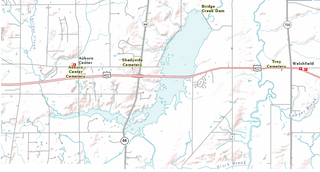
LaDue Reservoir is a reservoir located near Ohio State Route 44 and U.S. Route 422 in Auburn and Troy Townships in Geauga County, Ohio. Originally called the “Akron City Reservoir”, it was dedicated as the LaDue Reservoir on October 11, 1961, in honor of Wendell R. LaDue. The Geographic Names Information System recognized four variants names, including Akron City Reservoir, Bridge Creek Reservoir, Ladue Reservoir, and Wendell R. Ladue Reservoir.
Brittain, Ohio was a small settlement, part of the township of Springfield east of Akron, which has now been completely integrated into Akron. It was settled by the John T. Brittain Family in 1832.(A house built by the family ca. 1874 still stands on Brittain Road). Brittain was located at the crossroads of roads from Tallmadge (north), Mogadore (east), North Springfield (south) and Middlebury (west). It is 1,066 feet above sea level.

The Ohio and Erie Canal Towpath Trail is a multi-use trail that follows part of the former route of the Ohio & Erie Canal in Northeast Ohio.

Boston is an unincorporated community in Summit County, in the U.S. state of Ohio.
Sand Run is a stream located entirely within Summit County, Ohio. It is a tributary of the Cuyahoga River.
References
- ↑ U.S. Geological Survey Geographic Names Information System: Little Cuyahoga River
- ↑ "Little Cuyahoga River". nefcoplanning.org. Northeast Ohio Four County Regional Planning and Development Organization.
41°07′11″N81°31′45″W / 41.1196°N 81.5293°W
| | This Portage County, Ohio state location article is a stub. You can help Wikipedia by expanding it. |
| | This Summit County, Ohio state location article is a stub. You can help Wikipedia by expanding it. |