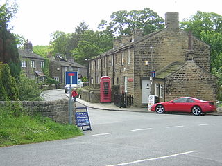
Esholt is a village and former civil parish in the metropolitan district of the City of Bradford, West Yorkshire, England. It is situated 3 miles (4.8 km) east of Shipley town centre, 1.5 miles (2.4 km) south-west of the A65 in Guiseley, 7 miles (11 km) north of Bradford City Centre, and 10 miles (16 km) north-west of Millennium Square, Leeds.

Guiseley is a town in the metropolitan borough of the City of Leeds, West Yorkshire, England. Historically part of the West Riding of Yorkshire, it is situated south of Otley and Menston and is now a north-western suburb of Leeds.

Yeadon is a town within the metropolitan borough of the City of Leeds, West Yorkshire, England.

Horsforth is a town and civil parish in the City of Leeds, West Yorkshire, England, five miles north-west of Leeds city centre. Historically a village within the West Riding of Yorkshire, it had a population of 18,895 at the 2011 Census. It became part of the City of Leeds metropolitan borough in 1974. In 1999, a civil parish was created for the area, and the parish council voted to rename itself a town council. The area is within the Horsforth ward of Leeds City Council, which also includes the southern part of Rawdon.
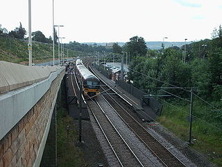
The Airedale line is one of the rail services in the West Yorkshire Metro area centred on West Yorkshire in northern England. The service is operated by Northern, on the route connecting Leeds and Bradford with Skipton. Some services along the line continue to Morecambe or Carlisle. The route covered by the service was historically part of the Midland Railway.

Rawdon is a village and civil parish in the metropolitan borough of the City of Leeds, West Yorkshire, England. It sits on the River Aire and on the A65 south of Yeadon.

Idle and Thackley is a ward within the City of Bradford Metropolitan District Council in the county of West Yorkshire, England, named after the villages of Idle and Thackley around which it is drawn. The population of 14,541 according to the 2001 UK census had increased at the 2011 Census to 16,135.

The West Yorkshire Built-up Area, previously known as the West Yorkshire Urban Area, is a term used by the Office for National Statistics (ONS) to refer to a conurbation in West Yorkshire, England, based on the cities of Leeds, Bradford and Wakefield, and the large towns of Huddersfield and Halifax. It is the 4th largest urban area in the United Kingdom. However, it excludes other towns and villages such as Featherstone, Normanton, Castleford, Pontefract, Hemsworth, Todmorden, Hebden Bridge, Knottingley, Wetherby and Garforth which, though part of the county of West Yorkshire, are considered independently. There are substantial areas of agricultural land within the designated area – more than in any other official urban area in England – many of the towns and cities are only just connected by narrow outlying strips of development.
Aireborough was a local government district in the West Riding of Yorkshire, England from 1937 to 1974. It was formed through the abolition of the urban districts of Guiseley, Yeadon and Rawdon and enlarged by the addition of parts of Otley urban district and parts of the civil parishes of Esholt, Hawksworth and Menston in the Wharfedale rural district on 1 April 1937. Aireborough Urban District was administered from Micklefield House in Rawdon which had been acquired by Rawdon UDC in 1930. The district is, since 1974, part of Leeds and Esholt is in Bradford

Apperley Bridge is a village in the metropolitan borough of the City of Bradford, in West Yorkshire, England in the Idle and Thackley Ward. Apperley Bridge is north-east of Bradford on the boundary with the City of Leeds bounded in the east by Carr Beck and to the south by Greengates. The village straddles the Leeds and Liverpool Canal and the River Aire. It takes its name from the old bridge over the river on Apperley Lane.

Idle is a residential suburban area in the city of Bradford, West Yorkshire, in England and was a separate village, and before that it was the Manor of Idle. Idle is loosely bordered by the areas of Eccleshill, Wrose, Thackley, Apperley Bridge, and Greengates, in the north-east of the city.

Thackley is a small suburb near Bradford, West Yorkshire in England. The village is loosely bordered by the village of Idle to the south, to the west by the West Royd area of Shipley and elsewhere by the Leeds and Liverpool Canal. Thackley is the northernmost part of Bradford south of the River Aire.

Greengates is a small suburban area in the north-east of the city of Bradford, West Yorkshire, in England. The area is bordered by Idle and Thackley to the north-west, whilst Thorpe Edge is to the west. To the south of Greengates is Ravenscliffe with the village of Eccleshill beyond that. Apperley Bridge is to the north. East bound of Greengates in the Leeds Metropolitan District is the village of Calverley.

The Otley and Ilkley Joint Railway was a railway line running between the towns of Otley and Ilkley in West Yorkshire. The line was managed and run jointly by the Midland Railway (MR) and the North Eastern Railway (NER) and was 6+1⁄2 miles (10 km) long. Opened to passenger traffic on 1 August 1865 and freight traffic some months later, the line ran for almost 100 years before partial closure in July 1965 when the line to Otley closed. Today passenger services run over the rest of the line as part of the West Yorkshire Passenger Transport Executive (WYPTE) Wharfedale Line.

St Oswald's Church in Guiseley, West Yorkshire, England, is an active Anglican parish church in the archdeaconry of Leeds and the Diocese of Leeds.
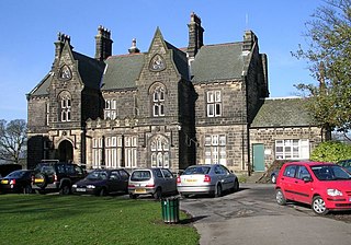
There are a number of listed buildings in West Yorkshire. The term "listed building", in the United Kingdom, refers to a building or structure designated as being of special architectural, historical, or cultural significance. Details of all the listed buildings are contained in the National Heritage List for England. They are categorised in three grades: Grade I consists of buildings of outstanding architectural or historical interest, Grade II* includes significant buildings of more than local interest and Grade II consists of buildings of special architectural or historical interest. Buildings in England are listed by the Secretary of State for Culture, Media and Sport on recommendations provided by English Heritage, which also determines the grading.
Idle and Thackley is a ward in the metropolitan borough of the City of Bradford, West Yorkshire, England. It contains 131 listed buildings that are recorded in the National Heritage List for England. Of these, two are listed at Grade II*, the middle of the three grades, and the others are at Grade II, the lowest grade. As well as the villages of Idle and Thackley, the ward includes the villages of Apperley Bridge and Greengates, and the surrounding area. The southern part of the ward is mainly residential, and the northern part is mainly rural. Most of the listed buildings are houses, cottages and associated structures, farmhouses and farm buildings. The other listed buildings include public houses, a church, a bridge, an archway to a former burial ground, a former toll house, a pair of locks on the Leeds and Liverpool Canal and an adjacent depot building, a war memorial, and a telephone kiosk.

Newlay is a suburb of Horsforth, in West Yorkshire, England. Originally a hamlet, it is now part of Horsforth parish in the City of Leeds District, and has its own conservation area. Newlay is situated on the Leeds and Liverpool Canal and the River Aire, some 5 miles (8 km) north west of Leeds city centre.

