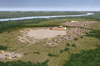
Etowah Indian Mounds (9BR1) are a 54-acre (220,000 m2) archaeological site in Bartow County, Georgia, south of Cartersville. Built and occupied in three phases, from 1000–1550 CE, the prehistoric site is located on the north shore of the Etowah River.

Angel Mounds State Historic Site, an expression of the Mississippian culture, is an archaeological site managed by the Indiana State Museum and Historic Sites that includes more than 600 acres of land about 8 miles (13 km) southeast of present-day Evansville, in Vanderburgh and Warrick counties in Indiana. The large residential and agricultural community was constructed and inhabited from AD 1100 to AD 1450, and served as the political, cultural, and economic center of the Angel chiefdom. It extended within 120 miles (190 km) of the Ohio River valley to the Green River in present-day Kentucky. The town had as many as 1,000 inhabitants inside the walls at its peak, and included a complex of thirteen earthen mounds, hundreds of home sites, a palisade (stockade), and other structures.

Wickliffe Mounds is a prehistoric, Mississippian culture archaeological site located in Ballard County, Kentucky, just outside the town of Wickliffe, about 3 miles (4.8 km) from the confluence of the Ohio and Mississippi rivers. Archaeological investigations have linked the site with others along the Ohio River in Illinois and Kentucky as part of the Angel phase of Mississippian culture. Wickliffe Mounds is controlled by the State Parks Service, which operates a museum at the site for interpretation of the ancient community. Listed on the National Register of Historic Places, it is also a Kentucky Archeological Landmark and State Historic Site.

Fort Hawkins was a fort built between 1806 and 1810 in the historic Creek Nation by the United States government under President Thomas Jefferson and used until 1824. Built in what is now Georgia at the Fall Line on the east side of the Ocmulgee River, the fort overlooked the sacred ancient earthwork mounds of the Ocmulgee Old Fields, now known as the Ocmulgee Mounds National Historical Park. The Lower Creek Trading Path passed by just outside the fort's northwestern blockhouse, and continued in a westerly direction until it reached a natural ford on the Ocmulgee River. A trading settlement and later the city of Macon, Georgia, developed in the area prior to the construction of the fort, with British traders being in the area as early as the 1680s. Later, the fort would become important to the Creek Nation, the United States, and the state of Georgia for economic, military, and political reasons.

Lake Jackson Mounds Archaeological State Park (8LE1) is one of the most important archaeological sites in Florida, the capital of chiefdom and ceremonial center of the Fort Walton Culture inhabited from 1050–1500. The complex originally included seven earthwork mounds, a public plaza and numerous individual village residences.

Mounds State Park is a state park near Anderson, Madison County, Indiana featuring Native American heritage, and ten ceremonial mounds built by the prehistoric Adena culture indigenous peoples of eastern North America, and also used centuries later by Hopewell culture inhabitants. It is separate from the similarly named Mounds State Recreation Area. The park receives about 400,000 visitors annually.

The Grave Creek Mound in the Ohio River Valley in West Virginia is one of the largest conical-type burial mounds in the United States, now standing 62 feet (19 m) high and 240 feet (73 m) in diameter. The builders of the site, members of the Adena culture, moved more than 60,000 tons of dirt to create it about 250–150 BC.

Moundville Archaeological Site, also known as the Moundville Archaeological Park, is a Mississippian culture archaeological site on the Black Warrior River in Hale County, near the modern city of Tuscaloosa, Alabama. Extensive archaeological investigation has shown that the site was the political and ceremonial center of a regionally organized Mississippian culture chiefdom polity between the 11th and 16th centuries. The archaeological park portion of the site is administered by the University of Alabama Museums and encompasses 185 acres (75 ha), consisting of 29 platform mounds around a rectangular plaza.

Spiro Mounds is an archaeological site located in present-day eastern Oklahoma that remains from an indigenous Indian culture that was part of the major northern Caddoan Mississippian culture. The 80-acre site is located within a floodplain on the southern side of the Arkansas River. The modern town of Spiro developed approximately seven miles to the south.

The Kolomoki Mounds is one of the largest and earliest Woodland period earthwork mound complexes in the Southeastern United States and is the largest in Georgia. Constructed from 350CE to 600CE, the mound complex is located in southwest Georgia, in present-day Early County near the Chattahoochee River.

Rock Eagle Effigy Mound is an archaeological site in Putnam County, Georgia, U.S. estimated to have been constructed c. 1000 BC to AD 1000. The earthwork was built up of thousands of pieces of quartzite laid in the mounded shape of a large bird. Although it is most often referred to as an eagle, scholars do not know exactly what type of bird the original builders intended to portray. It is listed on the National Register of Historic Places (NRHP) because of its significance. The University of Georgia administers the site. It uses much of the adjoining land for a 4-H camp, with cottages and other buildings, and day and residential environmental education.

Albany Mounds State Historic Site, also known as Albany Mounds Site, is a historic site operated by the Illinois Historic Preservation Agency. It spans over 205 acres of land near the Mississippi river at the northwest edge of the state of Illinois in the United States. In 1974, the site was added to the National Register of Historic Places list. The historical site is under the provision of the Illinois Historic Preservation Agency, a governmental agency founded in 1985 for the maintaining of historical sites within the state. In the 1990s, the site underwent a restoration project that aimed to return its appearance to its original condition.

The Old Stone Fort is a prehistoric Native American structure located in Coffee County, Tennessee, in the Southeastern United States. The structure was most likely built between 80 and 550 AD during the Middle Woodland period. It is the most complex hilltop enclosure found in the South and was likely used for ceremonial purposes rather than defense.

The Tobias-Thompson Complex, also known as the Little River Archeological District, is a complex of archaeological sites on the banks of the Little Arkansas River near Geneseo, Kansas, United States. The complex is an important set of sites that is one of the few in the region bridging the periods of prehistory and European contact, with a period of significance between 1500 and 1700 CE. It was designated a National Historic Landmark in 1964 and listed on the National Register of Historic Places in 1966.
Inyan Ceyaka Otonwe, also called Little Rapids or simply Inyan Ceyaka, was a summer planting village of the Wahpeton Dakota on the Minnesota River in what is now Louisville Township, Minnesota, United States. Located near present-day city of Jordan, the village was occupied by the Wahpeton during the early nineteenth century, and likely before. Burial mounds indicate that possible ancestors of the Dakota lived at the site as early as 100 CE. The site was listed on the National Register of Historic Places in 1999 for having local significance in the theme of archaeology. The unmarked site is preserved within the Carver Rapids unit of the Minnesota Valley State Recreation Area.
The Lamar mounds and village site (9BI2) is an important archaeological site on the banks of the Ocmulgee River in Bibb County, Georgia, several miles to the southeast of the Ocmulgee mound site. Both mound sites are part of the Ocmulgee Mounds National Historical Park, a national park and historic district created in 1936 and run by the U.S. National Park Service. Historians and archaeologists have theorized that the site is the location of the main village of the Ichisi encountered by the Hernando de Soto expedition in 1539.
The Schilling Archeological District is a prehistoric Native American archaeological site on private property on Lower Grey Cloud Island in Cottage Grove, Minnesota, United States. It consists of a habitation site and mound group with artifacts that date from the Early Woodland Period to the Late Prehistoric Period. It was listed on the National Register of Historic Places in 1978 for having state-level significance in the theme of archaeology. It was nominated for its rare Early Woodland component, Middle Mississippian cultural influences, and potential to show climatic adaptations over time.

The Upper Hay Lake Archeological District is a prehistoric Native American archaeological site in Jenkins Township, Minnesota, United States. It consists of about 75 linear mounds—including one of the state's longest at 725 feet (221 m)—plus the sites of a village and a portage. The mound grouping has also been dubbed Fort Poualak. The site was listed on the National Register of Historic Places in 1978 for having local significance in the theme of archaeology. It was nominated for indicating an area of substantial activity during the Blackduck phase of the Late Woodland period.

The Gordon–Schaust Site is a prehistoric Native American archaeological site in Crosslake, Minnesota, United States. It comprises two separate but nearly parallel groups of linear mounds, undated but well preserved. The site was listed on the National Register of Historic Places in 1974 for having state-level significance in the theme of archaeology.


