
Wake County is a county located in the U.S. state of North Carolina. As of the 2020 census, its population was 1,129,410, making it North Carolina's most populous county. From July 2005 to July 2006, Wake County was the 9th-fastest growing county in the United States, with Cary and Raleigh being the 8th- and 15th-fastest growing communities, respectively.

Johnston County is a county located in the U.S. state of North Carolina. As of the 2020 census, the population was 215,999. Its county seat is Smithfield.

Durham County is a county located in the U.S. state of North Carolina. As of the 2020 census, the population was 324,833, making it the sixth-most populous county in North Carolina. Its county seat is Durham, which is the only incorporated municipality predominantly in the county, though very small portions of cities and towns mostly in neighboring counties also extend into Durham County. The central and southern parts of Durham County are highly urban, consisting of the city as well as several unincorporated suburbs. Southeastern Durham County is dominated by the Research Triangle Park, most of which is in Durham County. The northern third of Durham County is rural in nature. Durham County is the core of the Durham-Chapel Hill, NC Metropolitan Statistical Area, which is also included in the Raleigh-Durham-Cary, NC Combined Statistical Area, which had an estimated population of 2,368,947 in 2023.

Knightdale is a town in Wake County, North Carolina, United States. As of the 2020 census, Knightdale has a population of 19,435, up from 11,401 in 2010. The U.S. Census Bureau estimates the town's population to be 17,843, as of July 1, 2019. Knightdale's population grew 10.4% from 2010 to 2013, making it the second fastest-growing community in the Research Triangle region for that time period.
Goldsboro, originally Goldsborough, is a city in and the county seat of Wayne County, North Carolina, United States. The population was 33,657 at the 2020 census. It is the principal city of and is included in the Goldsboro, North Carolina Metropolitan Statistical Area. The nearby town of Waynesboro was founded in 1787, and Goldsboro was incorporated in 1847. It is the county seat of Wayne County.
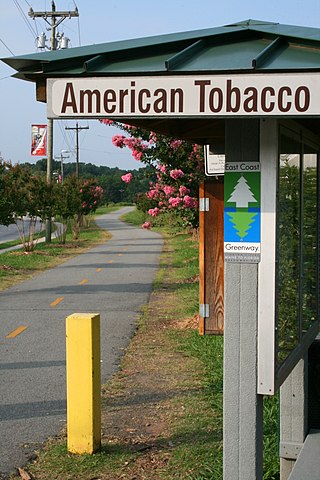
The American Tobacco Trail (ATT) is a 22.6-mile (36.4 km) long Rails-to-Trails project located in the Research Triangle region of North Carolina, running along an abandoned railroad bed originally built for the American Tobacco Company in the 1970s. The route crosses through portions of Durham County, Chatham County, and Wake County. The ATT is part of the East Coast Greenway and is open to pedestrians, cyclists, equestrians and other non-motorized users.
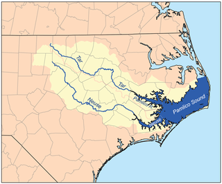
The Neuse River is a river rising in the Piedmont of North Carolina and emptying into Pamlico Sound below New Bern. Its total length is approximately 275 miles (443 km), making it the longest river entirely contained in North Carolina. The Trent River joins the Neuse at New Bern. Its drainage basin, measuring 5,630 square miles (14,600 km2) in area, also lies entirely inside North Carolina. It is formed by the confluence of the Flat and Eno rivers prior to entering the Falls Lake reservoir in northern Wake County. Its fall line shoals, known as the Falls of the Neuse, lie submerged under the waters of Falls Lake. This River also creates the beauty of the Neuse River Trail, a 34.5 miles (55.5 km) long greenway that stretches from Falls Lake Dam, Raleigh, North Carolina to Legend Park, Clayton, North Carolina.
WakeMed Health and Hospitals is a 919-bed healthcare system with multiple facilities placed around the metropolitan Raleigh, North Carolina area. WakeMed's main campus is located on New Bern Avenue in Raleigh, North Carolina. WakeMed serves multiple counties throughout the state and specializes in a variety of services including cardiology, gastroenterology, neurology, orthopedics, high-risk pregnancy, children's care, trauma, physical rehabilitation and critical care transport.

Bartons Creek Township is one of twenty townships within Wake County, North Carolina, United States. As of the 2010 census, Bartons Creek Township had a population of 22,055.

Neuse Township is one of twenty townships within Wake County, North Carolina, United States. As of the 2010 census, Neuse Township had a population of 73,617, a 52.6% increase over 2000.
Crabtree is a regional shopping mall located in Raleigh, North Carolina. At 1,343,109 square feet (124,778.9 m2), it is the largest enclosed mall in the Research Triangle area. The mall features Macy's, Belk, and Belk Men's Store.

Falls Lake is a 12,410 acre (50 km2) reservoir located in Durham, Wake, and Granville counties in North Carolina, United States. It extends 28 miles (45 km) up the Neuse River to its source at the confluence of the Eno, Little, and Flat rivers, and has a shoreline of 175 miles (280 km).
Neuse Correctional Institution is a minimum and medium security state prison for men in the United States, operated by the State of North Carolina Department of Public Safety in Goldsboro in Wayne County.

John W. Ligon GT/AIG Basics Magnet Middle School, formerly John W. Ligon Junior-Senior High School, is a public magnet middle school in the Wake County Public School System located in the Chavis Heights neighborhood of Raleigh, North Carolina. It was historically an all black high school in Raleigh until it was integrated in 1971.

Falls, is an unincorporated community in Wake County, North Carolina, United States, situated on Old Falls of Neuse Road, between Raleigh and Wake Forest, near the Wakefield Plantation development. Falls Dam, on the Neuse River, is within the community.
Neuse is an unincorporated community in Neuse Township, Wake County, North Carolina, United States. Located on the Neuse River, it is approximately nine miles north-northeast of downtown Raleigh.
The Little River Reservoir is located in Durham, North Carolina, United States, and is one of the main sources of drinking water for the town.
The H.F. Lee Energy Complex, formerly the Goldsboro Plant, is an electrical power generating complex operated by Duke Energy. The power complex was originally owned by the Carolina Power & Light Company, which inaugurated a coal-fired power plant in 1951. Two more coal plants were added in 1952 and 1962, and then oil-fueled turbines were added in 1967–71. In 2012 these units were shut down and replaced by four gas-fired units. The Quaker Neck Lake was built as a cooling pond for the coal-fired power stations, and is still used to supply cooling water. It was originally impounded by a low dam on the Neuse River, but in 1998 the dam was removed, while the lake remained contained in an earthen wall. This change allowed fish to migrate further upstream for spawning. Ash ponds near the lake hold toxic coal ash. There are plans to remove and recycle or bury the ash.
Walnut Creek is a 17.93 mi (28.86 km) long 4th order tributary to the Neuse River in Wake County. Its source is Maynard Pond in south-central Cary, and it flows generally eastward through several small reservoirs, including Lake Cramer in Cary as well as Lake Johnson and Lake Raleigh in Raleigh, before reaching its confluence with the Neuse just south of Poole Road in East Raleigh. The course of the creek closely parallels Interstate 40, running mostly along the north side of the freeway.
Wake Young Men's Leadership Academy (WYMLA) is a public secondary school for boys in Raleigh, North Carolina. It is a part of Wake County Public School System.