Little River Canyon Rim Parkway

Last updated

Coordinates: 34°22′22.1″N85°41′29.6″W / 34.372806°N 85.691556°W / 34.372806; -85.691556

Geographic coordinate system Coordinate system

A geographic coordinate system is a coordinate system that enables every location on Earth to be specified by a set of numbers, letters or symbols. The coordinates are often chosen such that one of the numbers represents a vertical position and two or three of the numbers represent a horizontal position; alternatively, a geographic position may be expressed in a combined three-dimensional Cartesian vector. A common choice of coordinates is latitude, longitude and elevation. To specify a location on a plane requires a map projection.

The Mushroom Rock, a landmark located in the middle of the parkway Little River Canyon Rim Parkway mushroom rock, Alabama April 2018 2.jpg
The Mushroom Rock, a landmark located in the middle of the parkway

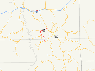
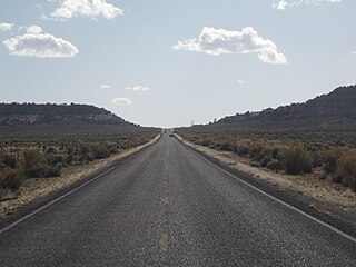
Little River Canyon Rim Parkway, also known as Alabama State Route 176 , Dekalb County Road 148 and Cherokee County Road 275, forms a 22-mile (35 km) scenic drive following the 16-mile-long (26 km) Little River Canyon National Preserve in northeastern Alabama. The highway was first designated in 1972 as State Route 275 , but was later renumbered to State Route 176 on the northern portion east of former Dekalb County Road 81 and turned back south of former Dekalb County Road 81 in September 1980. [2]

State Route 176 was created in September 1980 along previous County/Secondary State Roads 81 and 89 in DeKalb County and part of County/Secondary State Road 89 in Cherokee County. Part of the route took over what had been State Route 275 and forms the northern end of the Little River Canyon Rim Parkway: a scenic, but severely substandard highway following the northern rim of the limestone canyon for 22 miles (35 km).

Little River Canyon National Preserve

Little River Canyon National Preserve is a United States National Preserve located on top of Lookout Mountain near Fort Payne, Alabama, and DeSoto State Park. Created by an Act of Congress in 1992, the 15,288-acre (6,187 ha) preserve protects what is sometimes said to be the nation's longest mountaintop river, the Little River. The canyon was historically called "May's Gulf", "gulf" being a common term throughout the Cumberland Plateau for this sort of feature. Prior to being assigned to the National Park Service, the canyon area formed the southmost unit of Alabama's DeSoto State Park.

State Route 275 (SR-275) is a 8.250-mile (13.277 km) numbered state highway in Alabama. The route is a western and northern bypass route of Talladega. Commissioned in 1990, State Route 275 is the second incarnation of what was originally the designation for the entire Little River Canyon Rim Parkway.

As one of Alabama's most scenic attractions, the highway itself is only well-maintained on the state portion. The turned back portion, which was highly substandard previously, fell into serious disrepair under local control, almost to the point of abandonment. On the small part of the section maintained by Dekalb County, the road is less than two lanes wide. In Cherokee County, the road widens to two narrow lanes, but has miles of broken pavement and potholes. The roadway is also characterized by extremely steep grades both at the Johnnies Creek tributary and where the roadway descends from Lookout Mountain to the Canyon Mouth Park. While the State Route 176 portion has less severe grades, it is designed similarly with sharp curves and a couple sharp dropoffs at the edge of the canyon in some areas.

DeKalb County, Alabama County in the United States

DeKalb County is a county of the U.S. state of Alabama. As of the 2010 census, the population was 71,109. Its county seat is Fort Payne and it is named after Major General Baron Johan DeKalb.

Cherokee County, Alabama County in the United States

Cherokee County, Alabama is a county of the U.S. state of Alabama. As of the 2010 census, the population was 25,989. Its county seat is Centre,. The county is named for the Cherokee tribe.

Lookout Mountain mountain in northwestern Georgia, United States

Lookout Mountain is a mountain ridge located at the northwest corner of the U.S. state of Georgia, the northeast corner of Alabama, and along the Tennessee state line in Chattanooga. Lookout Mountain was the scene of the "Last Battle of the Cherokees" during the Nickajack Expedition, which took place in the 18th century, as well as the November 24, 1863 Battle of Lookout Mountain during the American Civil War.

In terms of scenery and attractions, not only does the route cross many seasonal tributaries, but also it has many lookout points, smaller canyons such as Bear Creek, Dees Branch and Johnnies Creek, and a view of the state's highest waterfall, Grace's High Falls. [3] Halfway along the route at Eberhardt Point, the highway passes by the site of Canyonland Amusement Park, an abandoned and mostly demolished park that featured a chairlift into the canyon floor. The existence of Canyonland Amusement Park was the likely reason that the original State Route 275 was created. This was especially notable, because a sign for the park (painted over, but with a Coca-Cola logo) was originally placed in an island in the middle of the road entrance on the southern terminus. Another point of interest is the Canyon Mouth Park, where Little River leaves the canyon just before entering Lake Weiss.

Grace's High Falls is a seasonal waterfall in the US state of Alabama, in Little River Canyon National Preserve. The waterfall is Alabama's highest at 133 feet.

Coca-Cola Carbonated soft drink

Coca-Cola, or Coke, is a carbonated soft drink manufactured by The Coca-Cola Company. Originally intended as a patent medicine, it was invented in the late 19th century by John Stith Pemberton and was bought out by businessman Asa Griggs Candler, whose marketing tactics led Coca-Cola to its dominance of the world soft-drink market throughout the 20th century. The drink's name refers to two of its original ingredients: coca leaves, and kola nuts. The current formula of Coca-Cola remains a trade secret, although a variety of reported recipes and experimental recreations have been published.

The state portion of the parkway received asphalt for the first time in 2004 (all of the parkway was originally paved with tar and gravel).

Related Research Articles

Blue Ridge Parkway scenic parkway in the United States

The Blue Ridge Parkway is a National Parkway and All-American Road in the United States, noted for its scenic beauty. The parkway, which is America's longest linear park, runs for 469 miles (755 km) through 29 Virginia and North Carolina counties, linking Shenandoah National Park to Great Smoky Mountains National Park. It runs mostly along the spine of the Blue Ridge, a major mountain chain that is part of the Appalachian Mountains. Its southern terminus is at U.S. 441 on the boundary between Great Smoky Mountains National Park and the Cherokee Indian Reservation in North Carolina, from which it travels north to Shenandoah National Park in Virginia. The roadway continues through Shenandoah as Skyline Drive, a similar scenic road which is managed by a different National Park Service unit. Both Skyline Drive and the Virginia portion of the Blue Ridge Parkway are part of Virginia State Route 48, though this designation is not signed.

State Route 89A is an 83.85-mile (134.94 km) state highway that runs from Prescott north to Flagstaff in the U.S. state of Arizona. The highway begins at SR 89 and heads northward from Prescott, entering Jerome. From Jerome, the route then heads to Cottonwood and Sedona. The highway is notable for its scenic value as it passes through Sedona and the Oak Creek Canyon. The route then enters Flagstaff, where it crosses Interstate 17 (I-17) and I-40. The highway ends at I-40 Business in Flagstaff. What is now SR 89A became a state highway in the late 1920s as SR 79. The highway was extended and improved several times through 1938. SR 79 was renumbered to U.S. Route 89A in 1941 and then to SR 89A in the early 1990s.

Colonial Parkway highway in Virginia

Colonial Parkway is a 23-mile (37 km) scenic parkway linking the three points of Virginia's Historic Triangle, Jamestown, Williamsburg, and Yorktown. It is part of the National Park Service's Colonial National Historical Park. Virginia's official state classification for the parkway is State Route 90003. With portions built between 1930 and 1957, it links the three communities via a roadway shielded from views of commercial development. The roadway is toll-free, is free of semi trucks, and has speed limits of around 35 to 45 mph. As a National Scenic Byway and All-American Road, it is also popular with tourists due to the James River and York River ends of the parkway.

California State Route 35 highway in California

California State Route 35, generally known as Skyline Boulevard, is a mostly two-lane road running along the ridge of the Santa Cruz Mountains from the low point of Highway 17 near Lexington Reservoir in Santa Clara County to State Route 1 just south of Daly City in San Mateo County, where it crosses SR 1 and loops around Lake Merced to become Sloat Boulevard in San Francisco.

State Route 67 is a 43.4 mi (69.8 km) long, north–south state highway in northern Arizona. Also called the Kaibab Plateau – North Rim Parkway, SR 67 is the sole road that links U.S. Route 89A at Jacob Lake to the North Rim of Grand Canyon National Park. Along the route, the road heads through the national park as well as Kaibab National Forest and is surrounded by evergreen trees. The section inside the national park is maintained by the National Park Service (NPS), whereas the section north of the entrance, completely within Kaibab National Forest, is owned by the Arizona Department of Transportation (ADOT). The road was built in the late 1920s and improved through the 1930s. In 1941, the road received its number, and was given its designation as the parkway in the 1980s. The parkway has received designations as a National Forest Scenic Byway as well as a National Scenic Byway.

State Route 273 is a 15.836-mile-long (25.486 km) route in Cherokee County in the northeastern part of Alabama. The southern terminus of the route is at its junction with State Route 68 at Leesburg. The northern terminus of the route is at its junction with State Route 35 at the community of Gaylesville.

State Route 35 (SR 35) is a 68.291-mile-long (109.904 km) state highway in the northeastern part of the U.S. state of Alabama. The southern terminus of the highway is at its intersection with SR 9 in rural Cherokee County northeast of Cedar Bluff and near the Georgia state line. The northern terminus of the highway is at Woodville in Jackson County where it has a second intersection with U.S. Route 72 (US 72).

The Lariat Loop Scenic & Historic Byway is a 40-mile (64 km) route in the foothills between Golden, Morrison, and Evergreen about 20 miles (32 km) west of Denver, Colorado.

Utah State Route 313 highway in Utah

State Route 313 (SR-313) is a Utah state highway in San Juan and Grand Counties. The highway has been designated the Dead Horse Point Mesa Scenic Byway. The highway is an access road for both the Island in the Sky district of Canyonlands National Park and Dead Horse Point State Park. The highway is a toll road in Dead Horse Point State Park. Westbound traffic is charged a state park entrance fee at the park boundary.

Utah State Route 279 highway in Utah

State Route 279 is a state highway in the U.S. state of Utah. The highway was constructed in 1962–1963 to service the Cane Creek potash mine and processing plant southwest of Moab. The highway was named one of the most beautiful highways opened to traffic in 1963. The entire length of SR-279 has been designated the Potash – Lower Colorado River Scenic Byway by the Utah State Legislature, however is known locally as Potash Road.

Utah State Route 211 highway in Utah

State Route 211 is a state route in Utah that is an access road for Newspaper Rock State Historic Monument and the Needles district of Canyonlands National Park. The entire length of the highway has been designated the Indian Creek Corridor Scenic Byway.

U.S. Route 191 in Utah section of U.S. Highway in Utah

U.S. Route 191 (US-191) is a major north–south state highway through the eastern part of the U.S. state of Utah. The present alignment of US-191, which stretches from Mexico to Canada, was created in 1981 through Utah. Previously the route had entered northern Utah, ending at US-91 in Brigham City, but with the completion of I-15 it was truncated to Yellowstone National Park and re-extended on a completely different alignment. In addition to a large portion of US-163, this extension absorbed several state routes: SR-33, most of SR-44, and SR-260.

Utah State Route 143 highway in Utah

State Route 143 (SR-143) is a state highway in the U.S. state of Utah. The entire highway has been designated the Brian Head-Panguitch Lake Scenic Byway as part of the Utah Scenic Byways program. This road has also been designated as Utah's Patchwork Parkway as part of the National Forest Scenic Byway program.

Colorado State Highway 74 highway in Colorado

State Highway 74 (SH 74) is a state highway in the U.S. state of Colorado. Running 18 miles (29 km) from Interstate 70 (I-70) in El Rancho to SH 8 in Morrison, the highway roughly follows a hook-shaped path running northwest–southeast. The section of the route north of the town of Evergreen is known as Evergreen Parkway and is a segment with a four- to six-lane roadway, with the section east of Evergreen mostly two lanes. The other section is known as the Bear Creek Canyon Scenic Mountain Drive, or just Bear Creek Road, and primarily parallels Bear Creek, passing through the towns of Kittredge and Idledale. The route, which is on the outskirts of Denver, passes through several of the city's mountain parks, including Bergen, Dedisse and Red Rocks parks.

State Route 73 is west-north state highway in East Tennessee. For most of its length, it is an unsigned companion route to U.S. Route 321.

References

  1. Mushroom Rock. Little River Canyon National Preserve. Retrieved April 21, 2018.
  2. "Scenic Drive - Little River Canyon National Preserve (U.S. National Park Service)". www.nps.gov. Retrieved 2016-11-04.
  3. "Graces High Falls Overlook - Little River Canyon National Preserve (U.S. National Park Service)". www.nps.gov. Retrieved 2016-11-04.