Related Research Articles

Lake Michigan is one of the five Great Lakes of North America. It is the second-largest of the Great Lakes by volume and the third-largest by surface area, after Lake Superior and Lake Huron. To the east, its basin is conjoined with that of Lake Huron through the 3+1⁄2-mile (5.6-kilometer) wide, 295-foot deep Straits of Mackinac, giving it the same surface elevation as its easterly counterpart; the two are geologically a single lake.

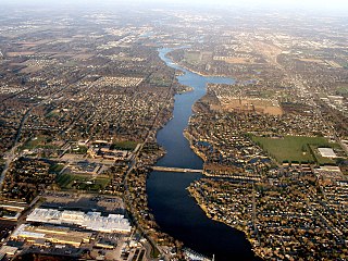
Sturgeon Bay is a city in and the county seat of Door County, Wisconsin, United States. The population was 9,646 at the 2020 Census. The city is well-known regionally for being the largest city of the Door Peninsula, after which the county is named.
The Menominee River is a river in northwestern Michigan and northeastern Wisconsin in the United States. It is approximately 116 miles (187 km) long, draining a rural forested area of northern Wisconsin and the Upper Peninsula of Michigan into Lake Michigan. Its entire course, with that of its tributary, the Brule River, forms part of the boundary between the two states.
The St. Joseph River is a tributary of Lake Michigan with a length of 206 miles (332 km). The river flows in a generally westerly direction through southern Michigan and northern Indiana, United States, to its terminus on the southeast shore of the lake. It drains a primarily rural farming area in the watershed of Lake Michigan. It was enormously important to Native Americans and greatly aided in the colonial exploration, settlement and administration of New France and the nascent United States as a canoe route between Lake Michigan and the watershed of the Mississippi River.
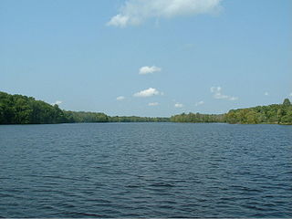
Sturgeon Bay is an arm of Green Bay extending southeastward approximately 10 miles into the Door Peninsula at the city of Sturgeon Bay, located approximately halfway up the Door Peninsula. The bay is connected to Lake Michigan by the Sturgeon Bay Ship Canal. The Potawatomi name for Sturgeon Bay is "Na-ma-we-qui-tong".

The Wolf River is a 225 mi (362 km) long tributary of the Fox River in northeastern Wisconsin in the Great Lakes region of the United States. The river is one of the two National Scenic Rivers in Wisconsin, along with the St. Croix River. The scenic portion is 24 miles (39 km) long. The river and its parent the Fox River and associated lakes are known for their sturgeon which spawn every spring upstream on the lower river until blocked by the Shawano Dam. The river flows through mostly undeveloped forestland southerly from central Forest County in the north to Lake Poygan in the south. The lake is part of the Winnebago Pool of lakes fed by both the Fox and Wolf Rivers. The Fox-Wolf basin is usually considered to be a single unified basin and the rivers themselves may be referred to as the Fox-Wolf River system.
The lake sturgeon, also known as the rock sturgeon, is a North American temperate freshwater fish, one of about 25 species of sturgeon. Like other sturgeons, this species is a bottom feeder and has a partly cartilaginous skeleton, an overall streamlined shape, and skin bearing rows of bony plates on the sides and back.

The Sturgeon Point Light Station is a lighthouse on Lake Huron in Haynes Township, Alcona County, northeastern lower Michigan. Established to ward mariners off a reef that extends 1.5 miles (2.4 km) lakeward from Sturgeon Point, it is today regarded as a historic example of a Cape Cod style Great Lakes lighthouse.
The Big Iron River is a 28.3-mile-long (45.5 km) river in western Ontonagon County on the Upper Peninsula of Michigan in the United States. It flows northwards, entering Lake Superior at the village of Silver City.
The Dead River is a 43.2-mile-long (69.5 km) river in Marquette County, Michigan. Its watershed is approximately 400 square miles (1,000 km2) in size. The river flows southeasterly from western Marquette County to its mouth on Lake Superior.
The Little Sturgeon River is a 12.3-mile-long (19.8 km) river in Cheboygan County, Michigan, in the United States. It is a tributary of the Indian River, part of the Mullett Lake/Cheboygan River system flowing to Lake Huron.
The Perch River is a 25.4-mile-long (40.9 km) tributary of the Sturgeon River in Iron County and Baraga County on the Upper Peninsula of Michigan in the United States. The Perch River begins at the outlet of Perch Lake in Bates Township and flows north through Ottawa National Forest to the Sturgeon River.
The Sante River is an 8.7-mile-long (14.0 km) stream on the Upper Peninsula of Michigan in the United States. Via the North Branch Otter River, Otter River, Sturgeon River and Portage River, its waters flow to Lake Superior.
The Tioga River is a 16.8-mile-long (27.0 km) tributary of the Sturgeon River in Baraga County, Michigan, United States.
The Silver River is a 31.3-mile-long (50.4 km) stream in the Upper Peninsula in the U.S. state of Michigan.

Sturgeon River is a 40.8-mile-long (65.7 km) river in the U.S. state of Michigan, flowing mostly northward through Otsego and Cheboygan counties.
Sturgeon River is a 63.6-mile-long (102.4 km) river in the U.S. state of Michigan, flowing mostly southward through Alger County and Delta County counties on the Upper Peninsula.
The Black Sturgeon River is a river in the Nelson River drainage basin in Kenora District, northwestern Ontario, Canada. It is a tributary of the Winnipeg River.
Sturgeon River is a 106-mile-long (171 km) river in Baraga County and Houghton counties in the U.S. state of Michigan. 25.0 miles (40.2 km) of the river were added to the National Wild and Scenic Rivers System in 1992.
References
- ↑ U.S. Geological Survey. National Hydrography Dataset high-resolution flowline data. The National Map Archived 2012-03-29 at the Wayback Machine , accessed February 3, 2012
- ↑ "Little Silver River | Natural Atlas". naturalatlas.com. Retrieved 2023-11-08.
| | This Houghton County, Michigan location article is a stub. You can help Wikipedia by expanding it. |