Related Research Articles
Lake Kickapoo is a reservoir located on the North Fork Little Wichita River in the Red River Basin of Archer County, Texas. It is neighbored by Archer City, Texas and Wichita Falls, Texas which reside within the Central Great Plains ecoregion.

Wichita County is a county located in the U.S. state of Texas. As of the 2020 census, its population was 129,350. The county seat is Wichita Falls. The county was created in 1858 and organized in 1882. Wichita County is part of the Wichita Falls, Texas, TX metropolitan statistical area.

Wichita Falls is a city in and the county seat of Wichita County, Texas, United States. It is the principal city of the Wichita Falls metropolitan statistical area, which encompasses all of Archer, Clay, and Wichita Counties. According to the 2020 census, it had a population of 102,316, making it the 39th-most populous city in Texas.

The Red River, or sometimes the Red River of the South to differentiate it from the Red River in the north of the continent, is a major river in the Southern United States. It was named for its reddish water color from passing through red-bed country in its watershed. It is known as the Red River of the South to distinguish it from the Red River of the North, which flows between Minnesota and North Dakota into the Canadian province of Manitoba. Although once a tributary of the Mississippi River, the Red River is now a tributary of the Atchafalaya River, a distributary of the Mississippi that flows separately into the Gulf of Mexico. This confluence is connected to the Mississippi River by the Old River Control Structure.

On Tuesday, April 10, 1979, a widespread and destructive outbreak of severe weather impacted areas near the Red River between Oklahoma and Texas. Thunderstorms developed over West and North Central Texas during the day within highly unstable atmospheric conditions following the northward surge of warm and moist air into the region, producing large hail, strong winds, and multiple tornadoes. At least 22 tornadoes were documented on April 10, of which two were assigned an F4 rating on the Fujita scale; four of the tornadoes caused fatalities.

U.S. Route 277 is a north–south United States Highway that is a spur route of U.S. Route 77. It no longer connects to its parent route, US 77, although it does intersect another one of its spur. It runs for 633 miles (1,019 km) across Oklahoma and Texas. US 277's northern terminus is in Newcastle, Oklahoma at Interstate 44, which is also the northern terminus of the H.E. Bailey Turnpike. Its southern terminus is in Carrizo Springs, Texas at U.S. Route 83. It passes through the states of Oklahoma and Texas.

The Chisholm Trail was a trail used in the post-Civil War era to drive cattle overland from ranches originated south of San Antonio, Texas, ran north across Oklahoma, and ended at Abilene, Kansas. The trail was established by Black Beaver, a Lenape guide and rancher, and his friend Jesse Chisholm, a Cherokee merchant. They collected and drove numerous cattle along the trail to Kansas, where they could be shipped east to achieve higher prices. The southern terminus was Red River Station, a trading post near the Red River along the northern border of Texas. The northern terminus was a trading post near Kansas City, Kansas. Chisholm owned both of these posts. In the years of the cattle drives, cowboys drove large herds from ranches across Texas to the Red River Station and then north to Kansas City.

The Wichita people, or Kitikiti'sh, are a confederation of Southern Plains Native American tribes. Historically they spoke the Wichita language and Kichai language, both Caddoan languages. They are indigenous to Oklahoma, Texas, and Kansas.

Texoma is an interstate region in the United States, split between Oklahoma and Texas. The name is a portmanteau of Texas and Oklahoma. Businesses use the term in their names to describe their intended service area. This includes 8 counties with a population estimate of 319,455.

The Tonkawa are a Native American tribe who now live in Oklahoma. Their Tonkawa language, now extinct, is a linguistic isolate.

The Tawakoni are a Southern Plains Native American tribe, closely related to the Wichitas. They historically spoke a Wichita language of the Caddoan language family. Currently, they are enrolled in the Wichita and Affiliated Tribes, a federally recognized tribe.
Jean-Baptiste Bénard de la Harpe was a French explorer who is credited with using the name "Little Rock" in 1722 for a stone outcropping on the bank of the Arkansas River used by early travelers as a landmark. Little Rock, Arkansas was subsequently named for the landmark.

Afton is an unincorporated community in northern Dickens County, Texas, United States.

Interstate 44 (I-44) in the U.S. state of Texas is an Interstate Highway that has a short, but regionally important, 15.398-mile (24.781 km) stretch connecting Wichita Falls with Oklahoma. Its entire length runs concurrently with U.S. Highway 277 (US 277) and US 281. I-44 provides access to downtown Wichita Falls and Sheppard Air Force Base. I-44 is known as the Central Freeway in Wichita Falls and the Red River Expressway in Burkburnett.

Memorial Stadium is an American football and soccer stadium in Wichita Falls, Texas located on Southwest Parkway at Barnett Road. It is owned and operated by the Wichita Falls Independent School District.

The Wichita River, part of the Red River watershed, lies in north-central Texas. Rising in northeastern Knox County at the confluence of its North and South Forks, the river flows 90 miles (140 km) northeast across Baylor, Archer, Wichita, and Clay counties before joining the Red River just west of Byers Bend in northern Clay County.
The Taovaya tribe of the Wichita people were Native Americans originally from Kansas, who moved south into Oklahoma and Texas in the 18th century. They spoke the Taovaya dialect of the Wichita language, a Caddoan language. Taovaya people today are enrolled in the Wichita and Affiliated Tribes, a federally recognized tribe headquartered in Anadarko, Oklahoma.
The exposed strata at the surface in and around Wichita Falls are the products of one ancient period of deposition with a modest amount of recent and modern alteration. In all cases, the strata are products of terrigenous (non-marine) environments dominated by fluvial depositional and erosional systems.
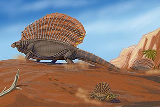
The Red Beds of Texas and Oklahoma are a group of Early Permian-age geologic strata in the southwestern United States cropping out in north-central Texas and south-central Oklahoma. They comprise several stratigraphic groups, including the Clear Fork Group, the Wichita Group, and the Pease River Group. The Red Beds were first explored by American paleontologist Edward Drinker Cope starting in 1877. Fossil remains of many Permian tetrapods have been found in the Red Beds, including those of Dimetrodon, Edaphosaurus, Seymouria, Platyhystrix, and Eryops. A recurring feature in many of these animals is the sail structure on their backs.
References
- USGS Hydrologic Unit Map - State of Texas (1974)
| | This article related to a river in Texas is a stub. You can help Wikipedia by expanding it. |