
Aitkin is a city in Aitkin County, Minnesota, United States. The population was 2,165 at the 2010 census. It is the county seat of Aitkin County.
The Willow River is a tributary of the Mississippi River, approximately 45 mi (72 km) long, in northern Minnesota in the United States.
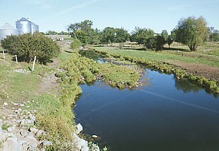
The Elk River is an 84.0-mile-long (135.2 km) river in east-central Minnesota in the United States. It is a tributary of the Mississippi River, draining a watershed of 630 square miles (1,600 km2).
The Nokasippi River is a 46.5-mile-long (74.8 km) tributary of the Mississippi River in central Minnesota in the United States. In the Ojibwe language, the river is called Nooke-ziibi. The term "tender" generally refers to the Bear Totem, but in this case refers to Chief Nokay, who was named after the Bear Totem and lived along the shores of Nokay Lake.
The Little Nokasippi River is a 13.8-mile-long (22.2 km) tributary of the Nokasippi River in Crow Wing County, Minnesota. It joins the Nokasippi just 1.0 mile (1.6 km) upstream from that river's mouth at the Mississippi River.

The Leaf River is a 43.6-mile-long (70.2 km) tributary of the Crow Wing River in west-central Minnesota in the United States. Via the Crow Wing, it is part of the Mississippi River watershed.

The Partridge River and its tributary the Little Partridge River are small rivers in rural west-central Minnesota in the United States. The Partridge is a 32.6-mile-long (52.5 km) tributary of the Crow Wing River, via which it is part of the Mississippi River watershed.
The Dead Moose River is a 15.2-mile-long (24.5 km) tributary of the Kettle River in eastern Minnesota in the United States. Via the Kettle and St. Croix rivers, it is part of the watershed of the Mississippi River.
The Willow River is a 31.4-mile-long (50.5 km) tributary of the Kettle River in eastern Minnesota in the United States. It is one of three rivers by that name in Minnesota. Via the Kettle and St. Croix rivers, it is part of the watershed of the Mississippi River.
The Cat River is a 16.3-mile-long (26.2 km) tributary of the Crow Wing River in the U.S. state of Minnesota. It is part of the Mississippi River drainage basin.
The Groundhouse River is a 39.8-mile-long (64.1 km) tributary of the Snake River in eastern Minnesota, United States. Via the Snake River and St. Croix River, it is part of the Mississippi River watershed flowing to the Gulf of Mexico.
The Gull River is a 14.2-mile-long (22.9 km) tributary of the Crow Wing River in the U.S. state of Minnesota. Rising at the outlet of Gull Lake, it flows south through Cass and Crow Wing counties to the Crow Wing River 2 miles (3 km) southeast of Sylvan. It is part of the Mississippi River drainage basin.
The Little Ann River is an 11.9-mile-long (19.2 km) tributary of the Ann River of Minnesota, United States.
The Little Elk River is a 29.4-mile-long (47.3 km) tributary of the Mississippi River in Morrison County, Minnesota, United States.
The Little Pine River is a 29.7-mile-long (47.8 km) tributary of the Pine River of Minnesota in the United States. Via the Pine River it is part of the Mississippi River watershed. The Little Pine River begins in the northeast corner of Crow Wing County at the outlet of Little Pine Lake and flows southwest to its junction with the Pine River in Crow Wing State Forest.
The Rabbit River is an 8.6-mile-long (13.8 km) tributary of the Mississippi River in northern Minnesota, United States. It rises at the outlet of Rabbit Lake, north of Crosby, and flows southwest through a chain of lakes past Ironton, joining the Mississippi River at the outlet of Little Rabbit Lake northwest of Riverton.
The Rice River is a 57.1-mile-long (91.9 km) tributary of the Mississippi River in northern Minnesota, United States. It rises in southeastern Aitkin County at the outlet of Porcupine Lake and flows generally north into Rice Lake National Wildlife Refuge, where it turns west and flows to the Mississippi 5 miles (8 km) northeast of Aitkin.
The Ripple River is a small river that starts at the outlet of Bay Lake of Crow Wing County, Minnesota, and ends in Aitkin, the county seat of Aitkin County, at its confluence with the Mississippi River. The river follows a circuitous route: as the crow flies, the distance between its source and mouth is 11 miles (18 km), but the total stream length is 42.3 miles (68.1 km).
The Split Rock River is a 20.4-mile-long (32.8 km) tributary of the Kettle River in eastern Minnesota, United States. It begins at the outlet of Split Rock Lake in eastern Aitkin County and flows east into Carlton County, reaching the Kettle River 4 miles (6 km) south of the city of Kettle River.


