Related Research Articles
Offa's Dyke is a large linear earthwork that roughly follows the border between England and Wales. The structure is named after Offa, the Anglo-Saxon king of Mercia from AD 757 until 796, who is traditionally believed to have ordered its construction. Although its precise original purpose is debated, it delineated the border between Anglian Mercia and the Welsh kingdom of Powys.

White Castle, also known historically as Llantilio Castle, is a ruined castle near the village of Llantilio Crossenny in Monmouthshire, Wales. The fortification was established by the Normans in the wake of the invasion of England in 1066, to protect the route from Wales to Hereford. Possibly commissioned by William fitz Osbern, the Earl of Hereford, it comprised three large earthworks with timber defences. In 1135, a major Welsh revolt took place and in response King Stephen brought together White Castle and its sister fortifications of Grosmont and Skenfrith to form a lordship known as the "Three Castles", which continued to play a role in defending the region from Welsh attack for several centuries.

Carl Wark is a rocky promontory on Hathersage Moor in the Peak District National Park, just inside the boundary of Sheffield, England. The promontory is faced by vertical cliffs on all but one side, which is protected by a prehistoric embankment. The cliffs and embankment form an enclosure that has been interpreted as an Iron Age hill fort, though the date of construction and purpose of the fortifications remains unknown. The site is a scheduled monument.

Cranmore Castle is an Iron Age earthwork situated on a hillside above the Devon town of Tiverton in south-west England. Its National Grid reference is SS958118. It is an English Heritage scheduled monument, and has been given a National Monument number of 34256.
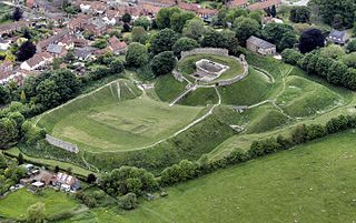
Castle Acre Castle and town walls are a set of ruined medieval defences built in the village of Castle Acre, Norfolk. The castle was built soon after the Norman Conquest by William de Warenne, the Earl of Surrey, at the intersection of the River Nar and the Peddars Way. William constructed a motte-and-bailey castle during the 1070s, protected by large earthwork ramparts, with a large country house in the centre of the motte. Soon after, a small community of Cluniac monks were given the castle's chapel in the outer bailey; under William, the second earl, the order was given land and estates to establish Castle Acre Priory alongside the castle. A deer park was created nearby for hunting.

Dolebury Warren is a 90.6 hectares biological Site of Special Scientific Interest (SSSI) and ancient monument near the villages of Churchill and Rowberrow in North Somerset, part of South West England. It is owned by the National Trust, who acquired the freehold in 1983, and managed by the Avon Wildlife Trust.
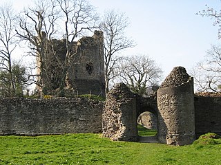
Longtown Castle, also termed Ewias Lacey Castle in early accounts, is a ruined Norman motte-and-bailey fortification in Longtown, Herefordshire. It was established in the 11th century by Walter de Lacy, reusing former Roman earthworks. The castle was then rebuilt in stone by Gilbert de Lacy after 1148, who also established the adjacent town to help pay for the work. By the 14th century, Longtown Castle had fallen into decline. Despite being pressed back into use during the Owain Glyndŵr rising in 1403, it fell into ruin. In the 21st century the castle is maintained by English Heritage and operated as a tourist attraction.

Loughor Castle is a ruined, medieval fortification located in the town of Loughor, Wales. The castle was built around 1106 by the Anglo-Norman lord Henry de Beaumont, during the Norman invasion of Wales. The site overlooked the River Loughor and controlled a strategic road and ford running across the Gower Peninsula. The castle was designed as an oval ringwork, probably topped by wicker fence defences, and reused the remains of the former Roman fort of Leucarum.

Castleshaw Roman fort was a castellum in the Roman province of Britannia. Although there is no evidence to substantiate the claim, it has been suggested that Castleshaw Roman fort is the site of Rigodunum, a Brigantian settlement. The remains of the fort are located on Castle Hill on the eastern side of Castleshaw Valley at the foot of Standedge but overlooking the valley. The hill is on the edge of Castleshaw in Greater Manchester. The fort was constructed in c. AD 79, but fell out of use at some time during the 90s. It was replaced by a smaller fortlet, built in c. 105, around which a civilian settlement grew. It may have served as a logistical and administrative centre, although it was abandoned in the 120s.

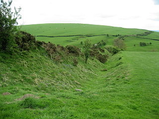
In archaeology, earthworks are artificial changes in land level, typically made from piles of artificially placed or sculpted rocks and soil. Earthworks can themselves be archaeological features, or they can show features beneath the surface.
Worlebury Camp is the site of an Iron Age hillfort on Worlebury Hill, north of Weston-super-Mare in Somerset, England. The fort was well defended with numerous walls, embankments and ditches around the site. Several large triangular platforms have been uncovered around the sides of the fort, lower down on the hillside. Nearly one hundred storage pits of various sizes were cut into the bedrock, and many of these contained human remains, coins, and other artefacts. During the 19th and 20th centuries the fort suffered damage and was threatened with complete destruction on multiple occasions. Now, the site is a designated Scheduled monument. It falls within the Weston Woods Local Nature Reserve which was declared to Natural England by the North Somerset Council in 2005.
Bledisloe Tump was a castle in the village of Awre in Gloucestershire, England.

Dajti Castle is a 1.12 hectares archaeological site in Albania, comprising the ruins of a Roman fortification and several dwellings. It belongs to late antiquity, probably having been built over Illyrian foundations. It lies at 1,200 metres (3,900 ft) altitude on top of a hill, west-side of Mount Dajti, close to Tirana. It was discovered in 1963 and eventually was inscribed in the list of the Cultural Monuments of Albania. In 2008 a three-year restoration project began, aiming to conduct further archaeological searching and surveys and to improve the nearby infrastructure for visitors and tourists.
Worcester's city walls are a sequence of defensive structures built around the city of Worcester in England between the 1st and 17th centuries. The first walls to be built around Worcester were constructed by the Romans. These early walls lasted beyond the fall of the Empire, and the defences encouraged several early Christian foundations to establish themselves in Worcester during the troubled 6th and 7th centuries. The Anglo-Saxons expanded Worcester in the 890s, forming a new walled, planned city, called a burh. The burh utilised the southern stretches of the old Roman walls, but pushed further north to enclose a much larger area. The Anglo-Saxon city walls were maintained by a share of taxes on a local market and streets, in an agreement reinforced by a royal charter.

Cornish promontory forts, commonly known in Cornwall as cliff castles, are coastal equivalents of the hill forts and Cornish "rounds" found on Cornish hilltops and slopes. Similar coastal forts are found on the north–west European seaboard, in Normandy, Brittany and around the coastlines of the British Isles, especially in Wales, Scotland and Ireland. Many are known in southwest England, particularly in Cornwall and its neighbouring county, Devon. Two have been identified immediately west of Cornwall, in the Isles of Scilly.
South Cerney Castle was an adulterine castle of Motte and bailey construction built in South Cerney, Gloucestershire in the mid-12th century. Today only slight earthwork remains and they are a scheduled monument.

Spoonley Wood Roman Villa is an ancient Roman villa located 2 km south-east of Sudeley Castle near the town of Winchcombe, in Gloucestershire, England. It was a courtyard-type villa excavated in 1882. Some remains of the villa, partly reconstructed, can still be seen in Spoonley Wood, and one mosaic is viewable under a corrugated iron roof.
Castle Rings is a univallate hill fort in the parish of Donhead St Mary in Wiltshire, England. The site is a Scheduled Ancient Monument. Castle Rings has been dated to the Iron Age and is at an altitude of 228 metres (748 ft) upon Upper Greensand sandstone beds. The bulk of the fort enclosure lies within the boundaries of Donhead St Mary parish but some of the outlying earthworks are in the neighbouring Sedgehill and Semley parish. In the mid-1980s a metal detectorist unearthed a hoard of stater coins of the Durotriges tribe within the hill fort.

Pinxton Castle, Derbyshire, is a scheduled monument in Castle Wood that straddles Pinxton and South Normanton. In its designation as a scheduled monument, Historic England describes it as having been a motte and fortified manor, with a moated site and five fishponds. Unlike most of the about 6000 moated sites in England, a large, fortified enclosure surrounded the moat.
References
- ↑ "Detailed Old Victorian Ordnance Survey". Archi UK: Old Maps of Britain.
- 1 2 3 Scott-Garrett, p.58.
- 1 2 Scott-Garrett, p.48.
- ↑ Scott-Garrett, pp.59-60.
- ↑ "Littledean Camp, Littledean, Glos". Ancient Monuments.
- ↑ "Littledean Camp". Google Maps.
- ↑ Scott-Garrett, pp.48-9.
- ↑ Scott-Garrett, p.49.