CJBC-FM is a public Canadian radio station, broadcasting at 90.3 MHz in Toronto, Ontario. A French-language station, it airs the programming of Radio-Canada's Ici Musique network. CJBC's studios are located in the Canadian Broadcasting Centre, while its transmitter is located atop First Canadian Place in Toronto's Financial District.

CIRV-FM is a Canadian radio station, broadcasting at 88.9 FM in Toronto, Ontario. The station airs a multicultural programming format. CIRV's studios are located on Dundas Street West in the Trinity-Bellwoods neighbourhood of Toronto, while its transmitter is located atop First Canadian Place in Toronto's Financial District.
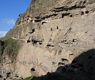
Vanis Kvabebi is a cave monastery in Samtskhe-Javakheti region of Georgia near Aspindza town and the more famous cave city of Vardzia. The complex dates from 8th century and consists of a defensive wall built in 1204 and a maze of tunnels running on several levels in the side of the mountain.

Kanch ; formerly known as Gyalto or Mets Gyalto, is a village in the Aragatsotn Province of Armenia. The town is mostly populated by Yezidis.
Laeva is a village in Tartu County, Estonia. It is the administrative centre of Laeva Parish.

Orta Salahlı is a village in the Agstafa Rayon of Azerbaijan.
Şıxımlı is a village and municipality in the Kurdamir Rayon of Azerbaijan.
Maramly is a village in the Sabirabad Rayon of Azerbaijan.

Dębniak is a village in the administrative district of Gmina Zgierz, within Zgierz County, Łódź Voivodeship, in central Poland. It lies approximately 11 kilometres (7 mi) north of Zgierz and 19 km (12 mi) north of the regional capital Łódź.
Wolica-Kolonia is a village in the administrative district of Gmina Karczmiska, within Opole Lubelskie County, Lublin Voivodeship, in eastern Poland. It lies approximately 4 kilometres (2 mi) south-east of Karczmiska, 8 km (5 mi) north-east of Opole Lubelskie, and 39 km (24 mi) west of the regional capital Lublin.
Wola Biechowska is a village in the administrative district of Gmina Pacanów, within Busko County, Świętokrzyskie Voivodeship, in south-central Poland. It lies approximately 4 kilometres (2 mi) south-west of Pacanów, 24 km (15 mi) south-east of Busko-Zdrój, and 63 km (39 mi) south-east of the regional capital Kielce.
Lipiny is a village in the administrative district of Gmina Zbuczyn, within Siedlce County, Masovian Voivodeship, in east-central Poland.
Karczówka is a village in the administrative district of Gmina Zwoleń, within Zwoleń County, Masovian Voivodeship, in east-central Poland. It lies approximately 3 kilometres (2 mi) north of Zwoleń and 101 km (63 mi) south-east of Warsaw.
Podole Małe is a village in the administrative district of Gmina Dębnica Kaszubska, within Słupsk County, Pomeranian Voivodeship, in northern Poland. It lies approximately 10 kilometres (6 mi) east of Dębnica Kaszubska, 21 km (13 mi) south-east of Słupsk, and 86 km (53 mi) west of the regional capital Gdańsk.
Galiny is a village in the administrative district of Gmina Górowo Iławeckie, within Bartoszyce County, Warmian-Masurian Voivodeship, in northern Poland, close to the border with the Kaliningrad Oblast of Russia. It lies approximately 15 kilometres (9 mi) north-west of Górowo Iławeckie, 32 km (20 mi) north-west of Bartoszyce, and 67 km (42 mi) north of the regional capital Olsztyn.
Mokajmy is a village in the administrative district of Gmina Rychliki, within Elbląg County, Warmian-Masurian Voivodeship, in northern Poland.
Zielonowo is a village located in the administrative district of Gmina Stawiguda, within Olsztyn County, Warmian-Masurian Voivodeship, in northern Poland. It lies approximately 7 kilometres (4 mi) to south of Stawiguda and 22 km (14 mi) south of the regional capital Olsztyn.

Větrušice is a village and municipality in Prague-East District in the Central Bohemian Region of the Czech Republic.
Koshkuiyeh District is a district (bakhsh) in Rafsanjan County, Kerman Province, Iran. At the 2006 census, its population was 22,048, in 5,303 families. The District has one city: Koshkuiyeh. The District has three rural districts (dehestan): Koshkuiyeh Rural District, Raviz Rural District, and Sharifabad Rural District.
Ruiloba is a municipality in Cantabria Province, Spain.


