
In Spain, a comarca is either a traditional territorial division without any formal basis, or a group of municipalities, legally defined by an autonomous community for the purpose of providing common local government services. In English, a comarca is equivalent to a district, county, area or zone.

Mazarrón is a municipality in the autonomous community and province of Murcia, southeastern Spain. The municipality has an area of 318.7 square kilometres (123.1 sq mi), and a population of 31,562 inhabitants in 2019. A military fort which was built between 1930 and 1936 during the reign of Alfonso XIII of Spain and the Second Spanish Republic exists as a tourist attraction on the old road between Mazarrón and Cartagena, and although it is accessible from the Bay of Mazarrón it is not in the municipality itself.

La Unión is situated in the Region of Murcia in the southeast of Spain. It has an area of 24.6 km², and had a population of 19,907 on 1 January 2018. It has an elevation of 86 m. Its average annual temperature is 17 °C. It has balmy winters. The sun shines 320 days per year. La Unión is situated in one of the sunniest areas in Europe; this kind of climate makes possible the many leisure activities, popular fiestas, sports, and cultural activities that are held in the town. The town is linked by a regular train to Cartagena which allows views of the past industrial heritage of the area and the more modern occupations of agriculture and tourism. La Unión lies within the built-up area of Cartagena and is surrounded on all landward sides by the City of Cartagena.

Ginés de la Jara is a semi-legendary saint of Spain. He is associated with the region surrounding Cartagena, of which he is co-patron. A hermitage was founded adjacent to the Mar Menor, and ruins of a monastery bearing his name date from before the Moorish conquest of 711 AD, that is, from the Visigothic era.

Fuente Álamo de Murcia is a town and municipality in the Region of Murcia, southern Spain. It is situated 22 km northwest of Cartagena and 35 km south west of Murcia. The town lies in the basin of the Mar Menor surrounded by the mountains of Algarrobo, Los Gómez, Los Victorias and the Carrascoy.

The Region of Murcia is an autonomous community of Spain located in the southeastern part of the Iberian Peninsula, on the Mediterranean coast. The region is 11,313 km2 (4,368 sq mi) in area and had a population of 1,511,251 as at the start of 2020. About a third of its population lives in the capital, Murcia, and a seventh in the second city, Cartagena. At 2,014 m (6,608 ft), the region's highest point is Los Obispos Peak in the Massif of Revolcadores.

Campo de Cartagena is a natural region (comarca) located in the Region of Murcia, in Spain. For administrative purposes, it is also known as Comarca del Campo de Cartagena or Comarca de Cartagena. It is located in the southeast of the Iberian Peninsula, forming a plain which extends from the Sierra de Carrascoy to the Mediterranean. The capital city is Cartagena, the most important Naval Base of the Spanish Navy in the Mediterranean Sea.

Cartagena is a Spanish city and a major naval station on the Mediterranean coast, south-eastern Iberia. As of January 2018, it has a population of 218,943 inhabitants. This makes Cartagena Murcia's second-largest municipality and Spain's sixth-largest city that is not a provincial-capital. The wider urban or metropolitan area of Cartagena, known as Campo de Cartagena, has a population of 409,586 inhabitants.

The Spanish municipality of Cartagena has 24 districts, known as diputaciones (councils). The original 17 districts established at the beginning of the 18th century were maintained throughout that century, and were the equivalent of the pedanías in other areas. This administrative structure was put in place in response to population increase in that era, and because the municipality was becoming less tractable.

The port of Cartagena is the port located in Cartagena, Spain. It is the fourth nationwide port in freight traffic behind Algeciras, Valencia and Barcelona. It occupies the eighth place in relation to the number of cruises. 60% of exports and the 80% of imports from the Region of Murcia are made through the port of Cartagena. More than 40% of the tourism that Cartagena receives is made by its port.
There is not consensus and agreement in the demarcation of the comarcas of the region and some of them varies largely depending on the comarcas proposal. According to La Verdad newspapers’ Region of Murcia Atlas, there are three main divisions corresponding to three different authors.

El Algar is a district of the Spanish municipality Cartagena. It is located in the east of Cartagena and has an area of 26.659 km2. It shares borders with Lentiscar at its north, San Félix at its east, La Unión municipality at its south east, El Beal at its south-west and a coastal salty lagoon named Mar Menor at its north-west. In 2019, 7,961 people were registered as inhabitants of the district.

The Cartagena–Los Nietos line is a narrow-gauge railway in the Murcia Region of Spain, connecting the city of Cartagena with smaller satellite towns to its east.
In the run up to the 2023 Spanish local elections, various organisations carry out opinion polling to gauge voting intention in local entities in Spain. Results of such polls for municipalities in the Region of Murcia are displayed in this article. The date range for these opinion polls is from the previous local elections, held on 26 May 2019, to the day the next elections were held, on 28 May 2023.
Jesús Santiago Pérez, sometimes known as Yellu, is a Spanish professional footballer who plays as a midfielder for Getafe CF.
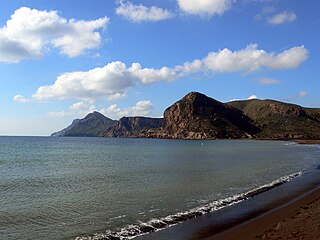
Sierra Minera de Cartagena-La Unión is a mountainous formation that extends east–west along 26 km of coastline from the city of Cartagena to Cape Palos, through the municipality of La Unión, in the Region of Murcia in Spain. Its maximum elevation is located on the Sancti Spíritus hill near Portmán, at 431 m altitude.

Club Deportiva Minera is a Spanish football team based in Llano del Beal, Cartagena, in the Region of Murcia. Founded in 1927 it plays in Segunda Federación – Group 4, holding home games at Estadio Municipal Ángel Celdrán, with a capacity of 2,000 seats.

Sociedad Minera y Metalúrgica de Peñarroya, usually abbreviated as SMMP, was a French-owned multinational mining company that operated between 1881 and 1989. During its existence it had an important presence in Spain.

El Estrecho de San Ginés is a town in the municipality of Cartagena, Region of Murcia, Spain.
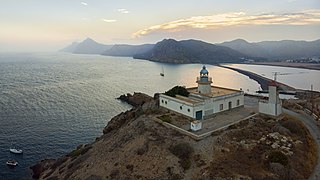
Portmán is a locality in the Region of Murcia, Spain, located to the south of the municipality of La Unión at the foot of the mining mountain range of Cartagena-La Unión in a bay bathed by the Mediterranean Sea.


