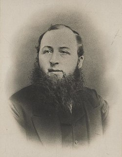
John Ceiriog Hughes, was a Welsh poet and collector of Welsh folk tunes, sometimes termed a Robert Burns of Wales. He was born at Penybryn Farm, overlooking the village of Llanarmon Dyffryn Ceiriog in the Ceiriog Valley of north-east Wales, then in Denbighshire, now part of Wrexham County Borough. One of eight children, he was a favourite of his mother, Phoebe, a midwife and herbal-medicine expert.
Denbighshire is a county in the north-east of Wales. Its borders differ from the historic county of the same name. This part of Wales contains the country's oldest known evidence of habitation – Pontnewydd (Bontnewydd-Llanelwy) Palaeolithic site has Neanderthal remains of some 225,000 years ago. Castles include Denbigh, Rhuddlan, Ruthin, Castell Dinas Bran and Bodelwyddan. St Asaph, one of Britain's smallest cities, has one of its smallest Anglican cathedrals.
Historic Denbighshire is one of thirteen traditional counties in Wales, a vice-county and a former administrative county, which covers an area in north east Wales. It is a maritime county, bounded to the north by the Irish Sea, to the east by Flintshire, Cheshire and Shropshire, to the south by Montgomeryshire and Merionethshire, and to the west by Caernarfonshire.

Glyndŵr was one of six districts of Clwyd between 1974 and 1996.

The Ceiriog Valley is the valley of the River Ceiriog in north-east Wales. Its Welsh name "Dyffryn Ceiriog" is the name of an electoral ward of Wrexham County Borough. The ward is the largest ward of the county borough by area and forms a strikingly-shaped salient of the county borough between Powys and Denbighshire.

Llansilin is a village and local government community in Montgomeryshire, Powys, Wales, 5 miles (8 km) west of Oswestry. The community, which includes Llansilin village, a large rural area and the hamlets of Moelfre and Rhiwlas as well as the remote parish of Llangadwaladr, had a population of 648 at the 2001 census, increasing to 698 at the 2011 Census. There is also an electoral ward including the nearby village of Llanrhaeadr-ym-Mochnant with a population of 2,295.

Glyn Ceiriog is the principal settlement of the Ceiriog Valley and a community in Wrexham County Borough, north-east Wales. Glyn Ceiriog translates simply as Ceiriog Valley, though there are other villages in the valley. The village and community is technically known, in traditional Welsh naming style, as Llansantffraid Glyn Ceiriog or sometimes Llansanffraid Glyn Ceiriog, which means church of St Ffraid in the Ceiriog Valley, but it has come to be known simply as Glyn Ceiriog, or even Glyn for short. The name Llansanffraid is now more associated with other villages of the same name.
Chirk was a rural district in the administrative county of Denbighshire from 1894 to 1935.
Ceiriog was a rural district in the administrative county of Denbighshire from 1935 to 1974.
Ruthin was a rural district in the administrative county of Denbighshire from 1894 to 1974.
Ceiriog is a Welsh name. It may refer to:
Denbigh was a county constituency centred on the town of Denbigh in North Wales. It returned one Member of Parliament (MP) to the House of Commons of the Parliament of the United Kingdom, elected by the first-past-the-post voting system.

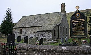
Llanarmon Dyffryn Ceiriog is a village in Wrexham County Borough, Wales. It lies on the River Ceiriog and is at the end of the B4500 road, five miles (8 km) south-west of Glyn Ceiriog and ten miles (16 km) north-west of Oswestry. It is within the Ceiriog Valley ward, Clwyd South Senedd constituency and Clwyd South UK parliamentary constituency. It is in the community of Ceiriog Ucha.
Ceiriog Ucha, also spelled as Ceiriog Uchaf, is a community in Wrexham County Borough, Wales. The community lies in the Ceiriog Valley and comprises the villages of Llanarmon Dyffryn Ceiriog and Tregeiriog as well as surrounding farmland and grouse and pheasant moors. It is a rural district set in low hills. The area is governed by Ceiriog Uchaf Community Council, and had a total population of 346, in 129 households, at the 2001 census. reducing to 317 in 2011.
Thomas Williams (1658–1726) was a Welsh Anglican priest and translator.
Llanarmon may refer to one of several villages in Wales:
Llanarmon Mynydd Mawr, occasionally referred to as Llanarmon Fach, is an isolated rural parish in Powys, Wales. It was formerly in Denbighshire, and from 1974 to 1996 was in the county of Clwyd. It measures 2 square miles (5 km2) and has a population of 40.

Tregeiriog is a village in Wrexham County Borough, Wales. It is in the community of Ceiriog Ucha on the B4500 road between Glyn Ceiriog and Llanarmon Dyffryn Ceiriog.
Llangadwaladr, formerly spelt Llancadwaladr in some sources, is an isolated mountain parish in Powys, Wales. It was formerly in the historic county of Denbighshire, and from 1974 to 1996 was in Clwyd. Some 7 miles west of the nearest town, Oswestry, it covers an area of sparsely settled hill farming country around the valley of the Afon Ysgwennant beneath Gyrn Moelfre.

Pandy is a hamlet in the Ceiriog Valley, Wrexham County Borough, Wales. It is located on the confluence of the River Ceiriog to the east, and the smaller River Teirw flowing from Nantyr moors to the north-west. The river level at Pandy of the River Ceiriog is ~665 feet (203 m), downstream from Llanarmon Dyffryn Ceiriog, and upstream from Glyn Ceiriog.