Gales from between north-north-east and east-north-east are the most important gales of the east coast of Spain. They are known locally as llevantades (in Catalan) and are an intense form of the llevant or levanter, i.e., north-easterly winds of long fetch, as opposed to diurnal coastal breezes. These gales are most frequent and dangerous in spring and autumn (February to May and October to December), and are generally associated with slow-moving depressions crossing the Mediterranean between France and Algeria.

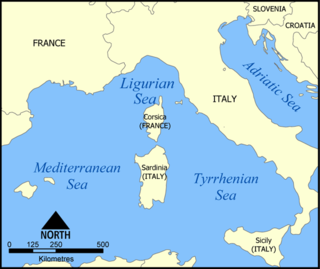
The Mediterranean Sea is a sea connected to the Atlantic Ocean, surrounded by the Mediterranean Basin and almost completely enclosed by land: on the north by Southern Europe and Anatolia, on the south by North Africa, and on the east by the Levant in West Asia. The Mediterranean has played a central role in the history of Western civilization. Geological evidence indicates that around 5.9 million years ago the Mediterranean was cut off from the Atlantic and was partly or completely desiccated over a period of some 600,000 years during the Messinian salinity crisis before being refilled by the Zanclean flood about 5.3 million years ago.

Spain is a country located in southwestern Europe occupying most of the Iberian Peninsula. It also includes a small exclave inside France called Llívia, as well as the Balearic Islands in the Mediterranean, the Canary Islands in the Atlantic Ocean 108 km (67 mi) off northwest Africa, and five places of sovereignty on and off the coast of North Africa: Ceuta, Melilla, Islas Chafarinas, Peñón de Alhucemas, and Peñón de Vélez de la Gomera.

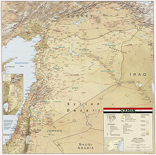
Syria is located in Western Asia, north of the Arabian Peninsula, at the eastern end of the Mediterranean Sea. It is bordered by Turkey to the north, Lebanon and Israel to the west and southwest, Iraq to the east, and Jordan to the south. It consists of mountain ranges in the west and a steep area inland. In the east is the Syrian Desert and in the south is the Jabal al-Druze Range. The former is bisected by the Euphrates valley. A dam built in 1973 on the Euphrates created a reservoir named Lake Assad, the largest lake in Syria. The highest point in Syria is Mount Hermon on the Lebanese border at 2,814 metres or 9,232 feet. Between the humid Mediterranean coast and the arid desert regions lies a semiarid steep zone extending across three-quarters of the country, which receives hot, dry winds blowing across the desert. Syria is extensively depleted, with 28 percent of the land arable, 4 percent dedicated to permanent crops, 46 percent utilized as meadows and pastures, and only 3 percent forest and woodland.

The mistral is a strong, cold, northwesterly wind that blows from southern France into the Gulf of Lion in the northern Mediterranean. It produces sustained winds often exceeding 66 km/h, sometimes reaching 185 km/h. It is most common in the winter and spring, and strongest in the transition between the two seasons. Periods of the wind exceeding 30 km/h for more than sixty-five hours have been reported.

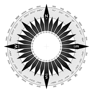
A compass rose, sometimes called a wind rose, rose of the winds or compass star, is a figure on a compass, map, nautical chart, or monument used to display the orientation of the cardinal directions and their intermediate points. It is also the term for the graduated markings found on the traditional magnetic compass. Today, a form of compass rose is found on, or featured in, almost all navigation systems, including nautical charts, non-directional beacons (NDB), VHF omnidirectional range (VOR) systems, global-positioning systems (GPS), and similar equipment.

A gale is a strong wind; the word is typically used as a descriptor in nautical contexts. The U.S. National Weather Service defines a gale as sustained surface winds moving at a speed of between 34 and 47 knots. Forecasters typically issue gale warnings when winds of this strength are expected. In the United States, a gale warning is specifically a maritime warning; the land-based equivalent in National Weather Service warning products is a wind advisory.

The points of the compass are a set of horizontal, radially arrayed compass directions used in navigation and cartography. A compass rose is primarily composed of four cardinal directions—north, east, south, and west—each separated by 90 degrees, and secondarily divided by four ordinal (intercardinal) directions—northeast, southeast, southwest, and northwest—each located halfway between two cardinal directions. Some disciplines such as meteorology and navigation further divide the compass with additional azimuths. Within European tradition, a fully defined compass has 32 'points'.

Sirocco, scirocco, or, rarely, siroc is a Mediterranean wind that comes from the Sahara and can reach hurricane speeds in North Africa and Southern Europe, especially during the summer season.

A gale warning is an alert issued by national weather forecasting agencies around the world in an event that maritime locations currently or imminently experiencing winds of gale force on the Beaufort scale. Gale warnings allow mariners to take precautionary actions to ensure their safety at sea or to seek safe anchorage and ride out the storm on land. Though usually associated with deep low-pressure areas, winds strong enough to catalyze a gale warning can occur in other conditions too, including from anticyclones, or high-pressure systems, in the continental interior. The winds are not directly associated with a tropical cyclone.

Hurricane Diana was the first major hurricane to hit the East Coast of the United States in nearly 20 years. Diana was the ninth tropical cyclone, fourth named storm, first hurricane, and first major hurricane of the 1984 Atlantic hurricane season. It caused moderate damage in North Carolina while it looped offshore and after it made landfall as a Category 2 hurricane. Forming on September 8, Diana moved northward and wandered across North Carolina for a couple of days during mid-September, dropping heavy rainfall. Once it left the state and accelerated east-northeast, Diana quickly evolved into an extratropical cyclone. Watches and warnings were issued for the storm along the East coast between eastern Florida and Virginia. Damages to the United States totaled $65.5 million. Three indirect fatalities were caused by the cyclone.

Hurricane Esther was the first large tropical cyclone to be discovered by satellite imagery. The fifth tropical cyclone, named storm, and hurricane of the 1961 Atlantic hurricane season, Esther developed from an area of disturbed weather hundreds of miles west-southwest of the southernmost Cape Verde Islands on September 10. Moving northwestward, the depression strengthened into Tropical Storm Esther on September 11, before reaching hurricane intensity on the following day. Early on September 13, Esther curved westward and deepened into a major hurricane. The storm remained a Category 3 hurricane for about four days and gradually moved in a west-northwestward direction. Late on September 17, Esther strengthened into a Category 5 hurricane with sustained winds of 160 mph (260 km/h) on September 18. The storm curved north-northeastward on September 19, while offshore of North Carolina. Esther began to weaken while approaching New England and fell to Category 3 intensity on September 21. The storm turned eastward early on the following day, and rapidly weakened to a tropical storm.

Traditionally, areas of tropical cyclone formation are divided into seven basins. These include the north Atlantic Ocean, the eastern and western parts of the northern Pacific Ocean, the southwestern Pacific, the southwestern and southeastern Indian Oceans, and the northern Indian Ocean. The western Pacific is the most active and the north Indian the least active. An average of 86 tropical cyclones of tropical storm intensity form annually worldwide, with 47 reaching hurricane/typhoon strength, and 20 becoming intense tropical cyclones, super typhoons, or major hurricanes.

The levant is an easterly wind that blows in the western Mediterranean Sea and southern France, an example of mountain-gap wind. In Roussillon it is called "llevant" and in Corsica "levante". In the western Mediterranean, particularly when the wind blows through the Strait of Gibraltar, it is called the Viento de Levante or the Levanter. It is also known as the Solano.

The 1995–96 Australian region cyclone season was an active Australian cyclone season, with Western Australia experiencing a record number of landfalling intense storms in the Pilbara region. The season produced a total of 19 tropical cyclones, of which 14 developed into named storms and 9 reached severe tropical cyclone status. The strongest of the season was Severe Tropical Cyclone Olivia, which also produced the highest recorded wind gust on record of 408 km/h (253 mph). Though several systems impacted land, the general sparsity of population centres in Australia limits the scale of damage. One person was confirmed to have been killed and cumulative losses were estimated at A$77 million (US$58.5 million).

The Braer Storm was the most intense extratropical cyclone ever recorded over the northern Atlantic Ocean. Developing as a weak frontal wave on 8 January 1993, the system moved rapidly northeast. The combination of the absorption of a second low-pressure area to its southeast, a stronger than normal sea surface temperature differential along its path, and the presence of a strong jet stream aloft led to a rapid strengthening of the storm, with its central pressure falling to an estimated 914 hPa on 10 January. Its strength was well predicted by forecasters in the United Kingdom, and warnings were issued before the low initially developed.

Mediterranean tropical-like cyclones, often referred to as medicanes but sometimes also as Mediterranean cyclones or as Mediterranean hurricanes, are meteorological phenomena occasionally observed over the Mediterranean Sea. On a few rare occasions, some storms have been observed reaching the strength of a Category 1 hurricane, on the Saffir–Simpson scale, and one storm has been recorded reaching Category 2 intensity. The main societal hazard posed by medicanes is not usually from destructive winds, but through life-threatening torrential rains and flash floods.

Cyprus has a subtropical climate - Mediterranean and semi-arid type - according to Köppen climate classification signes Csa and BSh, with very mild winters and warm to hot summers. Snow is possible only in the Troodos mountains in the central part of the island. Rain occurs mainly in winter, with summer being generally dry.

A Genoa low is a cyclone that forms or intensifies from a pre-existing cyclone to the south of the Alps over the Gulf of Genoa, Ligurian Sea, Po Valley and northern Adriatic. Vb cyclones are rare events which occur on average only 2.3 times per year.

Acts 27 is the twenty-seventh chapter of the Acts of the Apostles in the New Testament of the Christian Bible. It records the journey of Paul from Caesarea heading to Rome, but stranded for a time in Malta. The book containing this chapter is anonymous but early Christian tradition uniformly affirmed that Luke composed this book as well as the Gospel of Luke.