The Great River Road is a collection of state and local roads that follow the course of the Mississippi River through ten states of the United States. They are Minnesota, Wisconsin, Iowa, Illinois, Missouri, Kentucky, Tennessee, Arkansas, Mississippi and Louisiana. It formerly extended north into Canada, serving the provinces of Ontario and Manitoba.

U.S. Route 61 (US 61) is the official designation for a major United States highway which extends 1,400 miles (2,300 km) between New Orleans, Louisiana and the city of Wyoming, Minnesota. The highway generally follows the course of the Mississippi River, and is designated the Great River Road for much of its route. As of 2004, the highway's northern terminus in Wyoming, Minnesota, is at an intersection with Interstate 35 (I-35). Until 1991, the highway extended north on what is now Minnesota State Highway 61 through Duluth and across the Canada–U.S. border, near Grand Portage. Its southern terminus in New Orleans, Louisiana, is at an intersection with Tulane Avenue at South Broad Street. The highway is often called the Blues Highway because it connects Saint Paul, Minnesota; St. Louis, Missouri; Memphis, Tennessee; the Mississippi Delta, and New Orleans.

The St. Croix River is a tributary of the Mississippi River, approximately 169 miles (272 km) long, in the U.S. states of Wisconsin and Minnesota. The lower 125 miles (201 km) of the river form the border between Wisconsin and Minnesota. The river is a National Scenic Riverway under the protection of the National Park Service. A hydroelectric plant at St. Croix Falls supplies power to the Minneapolis–St. Paul metropolitan area.

A swing bridge is a movable bridge that has as its primary structural support a vertical locating pin and support ring, usually at or near to its center of gravity, about which the turning span can then pivot horizontally as shown in the animated illustration to the right. Small swing bridges as found over canals may be pivoted only at one end, opening as would a gate, but require substantial underground structure to support the pivot.

The Dubuque–Wisconsin Bridge is a steel bowstring arch bridge connecting Dubuque, Iowa, with still largely rural Grant County, Wisconsin. It is an automobile bridge that traverses the Mississippi River. It is one of two automobile bridges in the Dubuque area, the other being the Julien Dubuque Bridge, which is located about three miles (5 km) south.

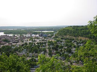
Great River Bluffs State Park is a state park of Minnesota, United States, on the Mississippi River southeast of Winona. Originally known as O. L. Kipp State Park, it was renamed in the late 1990s to describe better its resources. The park preserves steep-sided bluffs rising 500 feet (150 m) above the river and the narrow valleys between them, which support rare and fragile plant communities. Two of the bluffs have received further protection under the Minnesota Scientific and Natural Areas program, which are known as King's and Queen's Bluff Scientific and Natural Area.
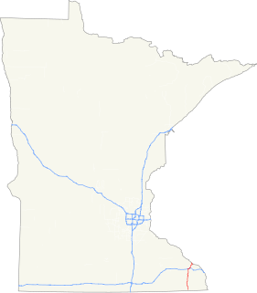
Minnesota State Highway 16 is a two-lane highway in southeast Minnesota, which runs from its interchange with Interstate Highway 90 in Dexter and continues east to its eastern terminus at the Wisconsin state line concurrent with U.S. Highways 14 and 61 outside La Crescent just west of La Crosse, Wisconsin.
The North Channel Bridge crosses the north channel of the Mississippi River between Latsch Island and Buffalo County, Wisconsin.

The Wabasha–Nelson Bridge is a truss bridge that connects Wabasha, Minnesota with Nelson, Wisconsin, crossing the Mississippi River. The bridge has a street setup, with one lane for motor vehicles in each direction. It carries Minnesota State Highway 60 and WI 25.

The I-90 Mississippi River Bridge consists of a pair of bridges that traverse the Mississippi River, connecting the La Crosse, Wisconsin area to rural Winona County, Minnesota. The current bridge fully opened to traffic in October 2016, replacing a previous plate girder bridge. It is part of the Interstate 90 route. There is another automobile crossing a few miles south of this bridge; the Mississippi River Bridge, a combination of two bridges, and the La Crosse West Channel Bridge, connecting La Crescent, Minnesota and La Crosse, Wisconsin.

The Mississippi River Bridge is a combination of two individual bridges which are also known as the Cass Street Bridge and the Cameron Avenue Bridge, as well as the Big Blue Bridges. They connect downtown La Crosse, Wisconsin to Barron Island, crossing the east channel of the Mississippi River. Another bridge, the La Crosse West Channel Bridge connects Barron Island to La Crescent, Minnesota. The Mississippi River Bridge carries U.S. Routes 14 and 61 with WI 16. There is another bridge about four miles upstream, the I-90 Mississippi River Bridge that connects North La Crosse, French Island, and Dresbach, Minnesota.

The Red Wing Bridge is a cantilever bridge which carries U.S. Route 63 across the Mississippi River from Wisconsin to Red Wing, Minnesota. It is officially named the Eisenhower Bridge for Dwight D. Eisenhower, the 34th President of the United States, who opened the bridge in November 1960. After the collapse of the I-35W bridge in Minneapolis, the State of Minnesota conducted a thorough investigation of the state's road infrastructure, especially its bridges. The Red Wing Bridge was identified as in need of replacement; construction on the replacement span began in 2017 and could take three to four years.

La Crosse Rail Bridge is a swing bridge that spans the Mississippi River between La Crescent, Minnesota and La Crosse, Wisconsin.

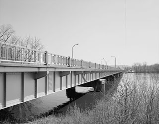
Main Channel Bridge (Winona) consists of a pair of bridges, the original cantilever bridge, and a concrete box girder bridge completed in 2016, that span the main channel of the Mississippi River in the United States between Winona, Minnesota, and Latsch Island. Another bridge, the North Channel Bridge, connects the island to rural Buffalo County, Wisconsin. The bridge carries Minnesota State Highway 43, which continues as Wisconsin Highway 54 at the Minnesota/Wisconsin state line on the nearby North Channel Bridge; in Winona, it connects to Winona Street.
Trunk Highway 60 (MN 60) is a highway in southern Minnesota, which runs from Iowa Highway 60 at the Iowa state line and continues east-northeast to its eastern terminus at the Wisconsin state line, where the route becomes Wisconsin Highway 25 upon crossing the Mississippi River.
Minnesota State Highway 43 is a highway in southeast Minnesota, which runs from its intersection with State Highway 44 in Mabel and continues north to its northern terminus at the Wisconsin state line at Winona, where it becomes Wisconsin Highway 54 upon crossing the Mississippi River.
Mississippi River Bridge may refer to:
The North Channel Bridge crosses the north channel of the Mississippi River between Latsch Island, Winona, Minnesota and Buffalo County, Wisconsin.