
Snowdonia, or Eryri, is a mountainous region and national park in North Wales. It contains all 15 mountains in Wales over 3000 feet high, including the country's highest, Snowdon, which is 1,085 metres (3,560 ft) tall. These peaks are all part of the Snowdon, Glyderau, and Carneddau ranges in the north of the region. The shorter Moelwynion and Moel Hebog ranges lie immediately to the south.

Gwynedd is a county in the north-west of Wales. It borders Anglesey across the Menai Strait to the north, Conwy, Denbighshire, and Powys to the east, Ceredigion over the Dyfi estuary to the south, and the Irish Sea to the west. The city of Bangor is the largest settlement, and the administrative centre is Caernarfon. The preserved county of Gwynedd, which is used for ceremonial purposes, includes the Isle of Anglesey.

The Dinorwig Power Station, known locally as Electric Mountain, or Mynydd Gwefru, is a pumped-storage hydroelectric scheme, near Dinorwig, Llanberis in Snowdonia national park in Gwynedd, north Wales. The scheme can supply a maximum power of 1,728 MW (2,317,000 hp) and has a storage capacity of around 9.1 GWh (33 TJ).

Llyn Llydaw is a natural lake in Snowdonia National Park on the flanks of Snowdon, Wales' highest mountain. This long thin lake has formed in a cwm about one-third of the way up the mountain. It is one of the most visited lakes in the United Kingdom, in that many thousands of people every year visit Snowdon and many walk past this lake on the Miners' Track.

The Glyderau are a mountain group in Snowdonia, North Wales. The name derives from the highest peaks in the range, Glyder Fawr and Glyder Fach. According to Sir Ifor Williams, the word "Glyder" derives from the Welsh word "Cludair", meaning a heap of stones.

Glyder Fawr is a mountain in Snowdonia, Wales, the highest peak in the Glyderau range at just over 1,000 metres. It is the fifth-highest mountain in Wales and has several walking and scrambling routes leading to its summit. According to Sir Ifor Williams, the word "Glyder" derives from the Welsh word "Gludair", meaning a heap of stones.

Carnedd Llewelyn, also spelled Carnedd Llywelyn, is a mountain massif in the Carneddau range in Snowdonia, north-west Wales. It is the highest point of the Carneddau and the second highest peak by relative height in Wales, 49th in the British Isles and lies on the border between Gwynedd and Conwy.

Cadair Idris or Cader Idris is a mountain in the Meirionnydd area of Gwynedd, Wales. It lies at the southern end of the Snowdonia National Park near the town of Dolgellau. The peak, which is one of the most popular in Wales for walkers and hikers, is composed largely of Ordovician igneous rocks, with classic glacial erosion features such as cwms, moraines, striated rocks, and roches moutonnées.
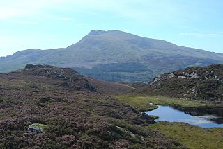
Moel Siabod is a mountain in Snowdonia, Wales, which sits isolated above the village of Dolwyddelan. At 872 metres (2,861 ft), it is the highest peak in the Moelwynion mountain range. The UK National Mountain Centre, Plas-y-Brenin, is located at the foot of Moel Siabod. From the top of the mountain, it is reputedly possible to see 13 of the 14 highest peaks in Wales on a clear day without turning one's head.

Cadair Berwyn, Cader Berwyn or Craig Uchaf is a mountain summit in north-east Wales with a height of 832 metres (2,730 ft) above sea level. It is the highest point in the Berwyn range, the highest in North East Wales and the highest significant summit in Wales outside the National Parks. Cadair Berwyn and Foel Cedig to the west are the two Marilyns that form the Berwyn range. The undulating plateau of the range also includes a large number of other summits above 2,000 feet (610 m), including satellite summits of Cadair Berwyn and many which are classed as Nuttalls.

The River Dwyryd, is a river in Gwynedd, Wales which flows principally westwards; draining to the sea into Tremadog Bay, south of Porthmadog.

Llyn Brenig is a reservoir located on Denbigh Moors in North Wales. The artificial lake, which was constructed between 1973 and 1976, was created by building an embankment dam across the Afon Brenig valley. It lies at 1,200 ft (370 m) above sea level on the border between the counties of Conwy and Denbighshire. It is used to manage the flow in the River Dee as part of the River Dee regulation system.

Nant Gwynant is a valley in northern Wales. The A498 road descends 600 feet (180 m) into the valley in about two miles (3 km) from Pen-y-Gwryd; it follows the Nant Cynnyd, the Afon Glaslyn and alongside Llyn Gwynant, then beside the Nant Gwynant river to Llyn Dinas and passing below Dinas Emrys to Beddgelert. The road continues through the Aberglaslyn Pass to Porthmadog.

Llyn Mair is a 14-acre (5.7 ha) artificial lake near Maentwrog, in Gwynedd in North Wales. It lies in the area of Tan-y-Bwlch, a little above Plas Tan-y-Bwlch, and is in the catchment area of the River Dwyryd. It was created by William Edward Oakeley as a 21st birthday present for his daughter Mair and as a water supply. It was built in 1889, and the nearby smaller Llyn Hafod-y-Llyn dates from the same period.
Craig y Llyn is a mountain situated to the south of the village of Rhigos in the Cynon Valley on the south side of the upper Vale of Neath and north of the Rhondda Valleys in South Wales; it is the highest point in the ancient kingdom and, later, county of Glamorgan (Morgannwg), and the southern Welsh coalfield plateau.

Llyn-y-Foel is a lake in Snowdonia, Wales. It is approximately 240 m across, 120 m wide and up to 2 m deep. It lies at 535m altitude at the foot of the main ridge of Moel Siabod at grid reference SH 714 547.

Pitt's Head is a distinctive rock located at grid reference SH576515, close to the A4085 road in Gwynedd, Wales. Its distinction lies in a resemblance to the profile of politician William Pitt the Younger.

Llyn Bedydd is a small lake in Wrexham County Borough, in northeastern Wales, near the border with England. It is 7 kilometres (4.3 mi) south west of Whitchurch. The lake and the surrounding woodland are designated as a Site of Special Scientific Interest.

Trefeurig is a community in Ceredigion, Wales, situated around 4 miles (6.4 km) north-east of Aberystwyth. It is a site of particular prehistoric, Roman, and Iron Age interest, and has a long history as a mining area. In 2011 the local population was estimated at 1,771 people.
