
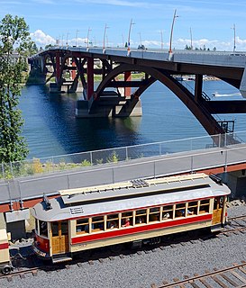
The Portland Streetcar is a streetcar system in Portland, Oregon, that opened in 2001 and serves areas surrounding downtown Portland. The 3.9-mile (6.3 km) NS Line runs from Northwest Portland to the South Waterfront via Downtown and the Pearl District. The Loop Service, which opened in September 2012 as the Central Loop, runs from Downtown to the Oregon Museum of Science and Industry via the Pearl District, the Broadway Bridge across Willamette River, the Lloyd District, and the Central Eastside Industrial District and added 3.3 miles (5.3 km) of route. In September 2015 the line was renamed as the Loop Service, with the A Loop traveling clockwise, and the B Loop traveling counterclockwise. The two-route system serves some 20,000 daily riders.
The Willamette Shore Trolley is a heritage railroad or heritage streetcar that operates along the west bank of the Willamette River between Portland and Lake Oswego in the U.S. state of Oregon. The right-of-way is owned by group of local-area governments who purchased it in 1988 in order to preserve it intact for possible rail transit use in the future. Streetcar excursion service began operating on a trial basis in 1987, lasting about three months, and regular operation on a long-term basis began in 1990. The Oregon Electric Railway Historical Society has been the line's operator since 1995.

The Portland Aerial Tram or OHSU Tram is an aerial tramway in Portland, Oregon, carrying commuters between the city's South Waterfront district and the main Oregon Health & Science University (OHSU) campus, located in the Marquam Hill neighborhood. It is one of only two commuter aerial tramways in the United States, the other being New York City's Roosevelt Island Tramway. The tram travels a horizontal distance of 3,300 feet (1,000 m) and a vertical distance of 500 feet (152 m) in a ride that lasts three minutes.
Sound Transit (ST), officially the Central Puget Sound Regional Transit Authority, is a public transit agency serving the Seattle metropolitan area in the U.S. state of Washington. It operates light rail service in Seattle and Tacoma, regional Sounder commuter rail, and Sound Transit Express bus service, as well as managing the regional ORCA fare card system. In 2017, Sound Transit services carried a total of 47 million passengers, including an average of 157,000 riders on weekdays.

The Waterfront Streetcar, officially the George Benson Waterfront Streetcar Line, was a heritage streetcar line run by King County Metro in Seattle, Washington, United States. It traveled for 1.6-mile (2.6 km) along Alaskan Way on the city's waterfront facing Elliott Bay. Service began on May 29, 1982, the first streetcars to run in Seattle since the closure of the Seattle Street Railway on April 13, 1941.

Transportation in Seattle is largely focused on the automobile much like many other cities in western North America; however Seattle is just old enough that its layout reflects the age when railways and trolleys predominated. These older modes of transportation were made for a relatively well-defined downtown area and strong neighborhoods at the end of several former streetcar lines, now mostly bus lines.

The MAX Yellow Line is a light rail service in Portland, Oregon, United States, operated by TriMet as part of the MAX Light Rail system. It connects North Portland, Portland City Center, and Portland State University. The line runs north–south from the Portland Expo Center to the Rose Quarter along a 5.8-mile (9.3 km) segment, referred to as the Interstate MAX, and northbound through downtown Portland along the Portland Transit Mall on Southwest 6th Avenue. It serves 17 stops between the Expo Center and PSU South/Southwest 6th and College stations; of these, seven stops occupy the median of North Interstate Avenue, giving that segment its name. The Yellow Line runs for approximately 21 hours daily from Monday to Sunday with a minimum headway of fifteen minutes during most of the day. It is the fourth-busiest service in the MAX system, carrying an average of 13,170 daily weekday riders in September 2018.

Like transportation in the rest of the United States, the primary mode of local transportation in Portland, Oregon is the automobile. Metro, the metropolitan area's regional government, has a regional master plan in which transit-oriented development plays a major role. This approach, part of the new urbanism, promotes mixed-use and high-density development around light rail stops and transit centers, and the investment of the metropolitan area's share of federal tax dollars into multiple modes of transportation. In the United States, this focus is atypical in an era when automobile use led many areas to neglect their core cities in favor of development along interstate highways, in suburbs, and satellite cities.
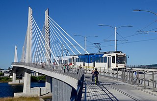
The MAX Orange Line is a light rail service in the MAX Light Rail system of TriMet in Portland, Oregon, United States. The $1.49 billion project is the second part of a two-phase transportation plan known as the South Corridor Project, bringing light rail service to Clackamas County. Starting in downtown Portland and following the Portland Transit Mall, the 7.3-mile (11.7 km) Orange Line runs between Union Station and Milwaukie, terminating at Park Avenue, in unincorporated Clackamas County just outside Milwaukie proper. The first construction work, related to the new Tilikum Crossing over the Willamette River began on June 30, 2011, and the line opened for service on September 12, 2015.

Streetcars or trolley(car)s were once the chief mode of public transit in hundreds of North American cities and towns. Most of the original urban streetcar systems were either dismantled in the mid-20th century or converted to other modes of operation, such as light rail. Today, only Toronto still operates a streetcar network essentially unchanged in layout and mode of operation.
The Waterfront West LRT (WWLRT) is a proposed streetcar line in Toronto, Ontario, Canada. The WWLRT is currently part of a City project called the Waterfront Transit Reset which also includes the East Bayfront LRT. The WWLRT was initially proposed as part of the Transit City plan to expand transit services offered by the Toronto Transit Commission that was announced March 16, 2007. The new line was to use existing parts of the Toronto streetcar system, extending from Union station to Long Branch Loop via Exhibition Place.

International District/Chinatown is a light rail station that is part of the Downtown Seattle Transit Tunnel in Seattle, Washington, United States. The station is located at the tunnel's south end, at 5th Avenue South and South Jackson Street in the Chinatown-International District neighborhood, and is served by the Central Link, part of Sound Transit's Link light rail system. The station is located adjacent to Sound Transit headquarters at Union Station, as well as intermodal connections to Amtrak and Sounder commuter rail at King Street Station, the First Hill Streetcar, and intercity BoltBus service.

The First Hill Streetcar, officially the First Hill Line, is a streetcar route in Seattle, Washington, United States, forming part of the modern Seattle Streetcar system. It travels 2.5 miles (4.0 km) between several neighborhoods in central Seattle, including the International District, First Hill, and Capitol Hill. The line has ten stops and runs primarily in mixed traffic on South Jackson Street and Broadway.
The Loop Trolley is a 2.2-mile (3.5 km), 10-station heritage streetcar line in St. Louis, Missouri. It connects the Delmar Loop district and the Missouri History Museum in Forest Park, serving parts of University City and the St. Louis neighborhoods of DeBaliviere Place, Skinker/DeBaliviere, and the West End. It also serves two MetroLink light-rail stations: Delmar Loop and Forest Park–DeBaliviere.

The Seattle Streetcar is a system of two modern streetcar lines operating in the city of Seattle, Washington. The South Lake Union line opened first in 2007 and was followed by the First Hill line in 2016. The two lines are unconnected, but share similar characteristics: frequent service, station amenities, and vehicles. Streetcars typically arrive every 10–15 minutes most of the day, except late at night. The streetcar lines are owned by the Seattle Department of Transportation and operated by King County Metro.
East Bayfront LRT is a streetcar line proposed to run along Queens Quay East from Bay Street to Parliament Street, connecting Union station to the East Bayfront area of Toronto, Ontario, Canada. It will complement the existing 509 Harbourfront service which connects Union Station to Queens Quay west of Bay Street.
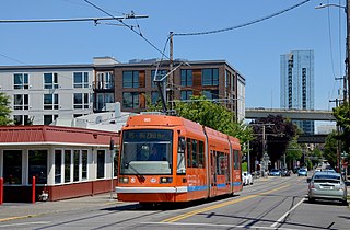
The North South Line is a streetcar service in Portland, Oregon, United States, that is part of the Portland Streetcar system. Operated by Portland Streetcar, Inc. and TriMet, it travels approximately 4 miles (6.4 km) per direction between Northwest 23rd & Marshall and Southwest Lowell & Bond, serving 39 stations. The line connects Portland's Northwest District, Pearl District, Downtown, Portland State University, and South Waterfront. It runs every day of the week between 15 and 18 hours per day, operating on headways of 15 to 20 minutes. The NS Line is the busiest of Portland's three streetcar routes; it carried an average of 8,751 weekday riders in September 2018.
The Seattle Department of Transportation (SDOT) is a municipal government agency in Seattle, Washington that is responsible for the maintenance of the city's transportation systems, including roads, bridges, and public transportation. The agency is funded primarily by taxes that are supplemented by voter-approved levies from other sources; its budget in 2015 was $429 million.

The Brooklyn–Queens Connector, abbreviated the BQX, is a proposed streetcar line in New York City. It is planned to operate 24/7 on a north-south corridor along the East River between the boroughs of Queens and Brooklyn.


