Related Research Articles

A post office is a public facility and a retailer that provides mail services, such as accepting letters and parcels, providing post office boxes, and selling postage stamps, packaging, and stationery. Post offices may offer additional services, which vary by country. These include providing and accepting government forms, and processing government services and fees. The chief administrator of a post office is called a postmaster.

The United States Census Bureau (USCB), officially the Bureau of the Census, is a principal agency of the U.S. Federal Statistical System, responsible for producing data about the American people and economy. The Census Bureau is part of the U.S. Department of Commerce and its director is appointed by the President of the United States.

Alameda County is located in the state of California in the United States. As of the 2020 census, the population was 1,682,353, making it the 7th-most populous county in the state and 21st most populous nationally. The county seat is Oakland. Alameda County is in the San Francisco Bay Area, occupying much of the East Bay region.

Cape Canaveral is a city in Brevard County, Florida. The population was 9,912 at the 2010 United States Census. It is part of the Palm Bay–Melbourne–Titusville Metropolitan Statistical Area.
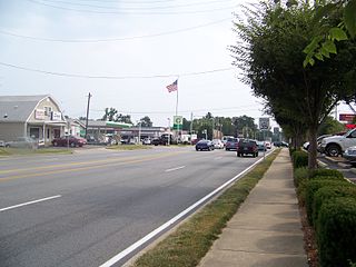
Lyndon is a home rule-class city in Jefferson County, Kentucky, United States. The population was 11,002 at the 2010 census, up from 9,369 at the 2000 census.

LaGrange is a town in Dutchess County, New York, United States. The population was 15,730 at the 2010 census. The town was named after the ancestral estate of the wife of the Marquis de Lafayette.

State College is a home rule municipality in Centre County in the Commonwealth of Pennsylvania. It is a college town, dominated economically and demographically by the presence of the University Park campus of the Pennsylvania State University.
Millbank is an area of central London in the City of Westminster. Millbank is located by the River Thames, east of Pimlico and south of Westminster. Millbank is known as the location of major government offices, Burberry headquarters, the Millbank Tower and prominent art institutions such as Tate Britain and the Chelsea College of Art and Design.

The Palestinian Central Bureau of Statistics is the official statistical institution of the State of Palestine. Its main task is to provide credible statistical figures at the national and international levels. It is a state institution that provides service to the governmental, non – governmental and private sectors in addition to research institutions and universities. It is established as an independent statistical bureau. The PCBS publishes the Statistical Yearbook of Palestine and the Jerusalem Statistical Yearbook annually.
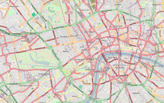
Central London is the innermost part of London, in England, spanning several boroughs. Over time, a number of definitions have been used to define the scope of Central London for statistics, urban planning and local government. Its characteristics are understood to include a high density built environment, high land values, an elevated daytime population and a concentration of regionally, nationally and internationally significant organisations and facilities.

Hato Rey is a former barrio located in the northwest part of the dissolved municipality of Río Piedras. It now stretches over three barrios, of the municipality of San Juan, Puerto Rico:
London overspill communities are the communities created as a result of the government policy of moving residents out of Greater London into other areas in the South East of England between the 1930s and the 1970s. These largely consisted of council houses and new towns.

The Harrisburg–Carlisle metropolitan statistical area, officially the Harrisburg–Carlisle, PA Metropolitan Statistical Area, and also referred to as the Susquehanna Valley, is defined by the Office of Management and Budget as an area consisting of three counties in South Central Pennsylvania, anchored by the cities of Harrisburg and Carlisle.

Briggsdale is an unincorporated town, a post office, and a census-designated place (CDP) located in and governed by Weld County, Colorado, United States. The CDP is a part of the Greeley, CO Metropolitan Statistical Area. The Briggsdale post office has the ZIP Code 80611. At the United States Census 2010, the population of the 80611 ZIP Code Tabulation Area was 25,553 including adjacent areas.

Statistics Indonesia, is a non-departmental government institute of Indonesia that is responsible for conducting statistical surveys. Its main customer is the government, but statistical data is also available to the public. Annual surveys include national and provincial socio-economics, manufacturing establishments, population and the labour force.

The Division of Alcoholic Beverages and Tobacco (ABT) is the Florida state government agency which licenses and regulates the sale of alcoholic beverages and tobacco. It is part of the Florida Department of Business and Professional Regulation (DBPR).
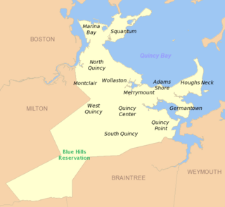
South Quincy is a neighborhood of Quincy, Massachusetts. Located in the south central portion of the city, South Quincy is bordered on the north by Quincy Center and West Quincy, on the east by Quincy Avenue and the Quincy Point neighborhood, on the south by Braintree and on the west by Interstate 93.

National Weather Service Lincoln, Illinois also known as National Weather Service Central Illinois is a weather forecast office responsible for monitoring weather conditions for 35 counties in Central and Southeastern Illinois. The Central Illinois office initially consisted of two forecast offices in Peoria and Springfield until the current location in Lincoln became the sole local forecast office in 1995. Federal meteorology offices and stations in the region date back to the 19th century when the Army Signal Service began taking weather observations using weather equipment at the Springer Building in Springfield. Since that time the presence of the National Weather Service greatly increased with the installation of new weather radars, stations and forecast offices. The current office in Lincoln maintains a WSR-88D (NEXRAD) radar system, and Advanced Weather Interactive Processing System (AWIPS) that greatly improve forecasting in the region. Lincoln is in charge of weather forecasts, warnings and local statements as well as aviation weather.

A commuter town is a populated area that is primarily residential rather than commercial or industrial. Routine travel from home to work and back is called commuting, which is where the term comes from. A commuter town may be called by many other terms: "bedroom community", "bedroom town", "bedroom suburb" (US), "dormitory town", or "dormitory suburb" (Britain/Commonwealth/Ireland). In Japan, a commuter town may be referred to by the wasei-eigo coinage "bed town". The term "exurb" was used from the 1950s, but since 2006, is generally used for areas beyond suburbs and specifically less densely built than the suburbs to which the exurbs' residents commute.
The Dabur ITO metro station is a station on the Delhi Metro, under the Violet Line. It was inaugurated on 8 June 2015 by the Urban Development Minister M Venkaiah Naidu and Delhi Chief Minister Arvind Kejriwal.
References
- ↑ Hall, R. K.; Location of Offices Bureau (1972). "The movement of offices from Central London". Regional Studies . Routledge. 6 (4): 385–392. doi:10.1080/09595237200185341.
- ↑ Commuters to the London Office - a survey
| General | |
|---|---|
| National libraries | |