
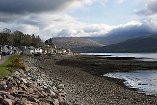
Plockton is a village in the Lochalsh, Wester Ross area of the Scottish Highlands with a 2020 population of 468.

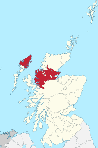
Ross and Cromarty, also referred to as Ross-shire and Cromartyshire, is a variously defined area in the Highlands and Islands of Scotland. There is a registration county and a lieutenancy area in current use, the latter of which is 8,019 square kilometres in extent. Historically there has also been a constituency of the Parliament of the United Kingdom, a local government county, a district of the Highland local government region and a management area of the Highland Council. The local government county is now divided between two local government areas: the Highland area and Na h-Eileanan Siar. Ross and Cromarty border Sutherland to the north and Inverness-shire to the south.
Scalpay is an inhabited island in the Inner Hebrides of Scotland which has a population of 4.
Lochcarron is a village, community and civil parish in the Wester Ross area of Highland, Scotland. It has a population of 923.

The Kyle of Lochalsh line is a primarily single-track railway line in the Scottish Highlands, from Dingwall to Kyle of Lochalsh. Many of the passengers are tourists, but there are also locals visiting Inverness for shopping, and commuters. All services are provided by ScotRail and run beyond Dingwall to Inverness. In the past there were some through services to and from Glasgow, Edinburgh or Aberdeen. None of the line is electrified, and all trains on the line are diesel-powered, as are all other trains in the Scottish Highlands.
Loch Kishorn is a sea loch in the north-west Highlands of Scotland. Kishorn is a collective name used to refer to a group of populated settlements located next to the loch.

Wester Ross is an area of the Northwest Highlands of Scotland in the council area of Highland. The area is loosely defined, and has never been used as a formal administrative region in its own right, but is generally regarded as lying to the west of the main watershed of Ross, thus forming the western half of the county of Ross and Cromarty. The southwesternmost part of Ross and Cromarty, Lochalsh, is not considered part of Wester Ross by the local tourist organisation, Visit Wester Ross, but is included within the definition used for the Wester Ross Biosphere Reserve.
Loch Torridon is a sea loch on the west coast of Scotland in the Northwest Highlands. The loch was created by glacial processes and is in total around 15 miles (25 km) long. It has two sections: Upper Loch Torridon to landward, east of Rubha na h-Airde Ghlaise, at which point it joins Loch Sheildaig; and the main western section of Loch Torridon proper. Loch a' Chracaich and Loch Beag are small inlets on the southern shores of the outer Loch, which joins the Inner Sound between the headlands of Rubha na Fearna to the south and Red Point to the north.

The Inner Sound is a strait separating the Inner Hebridean islands of Skye, Raasay and South Rona from the Applecross peninsula on the Scottish mainland. The Inner Sound is the location of BUTEC, a Royal Navy submarine sensor and emissions range.
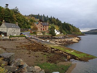
Stromeferry is a village, located on the south shore of the west coast sea loch, Loch Carron, in western Ross-shire, Scottish Highlands and is in the Scottish council area of Highland. Its name reflects its former role as the location of one of the many coastal ferry services which existed prior to the expansion of the road network in the 20th century.
Duncraig railway station is a remote railway station by the shore of Loch Carron on the Kyle of Lochalsh Line, originally (privately) serving Duncraig Castle, a mansion near Plockton, in the Highland council area of northern Scotland. The station is 57 miles 9 chains (91.9 km) from Dingwall, between Stromeferry and Plockton. ScotRail, who manage the station, operate all services at the station.
Ross-shire is a historic county in the Scottish Highlands. The county borders Sutherland to the north and Inverness-shire to the south, as well as having a complex border with Cromartyshire – a county consisting of numerous enclaves or exclaves scattered throughout Ross-shire's territory. Ross-shire includes most of Ross along with Lewis in the Outer Hebrides. Dingwall is the traditional county town. The area of Ross-shire is based on that of the historic province of Ross, but with the exclusion of the many enclaves that form Cromartyshire.

Port an Eòrna is the Scottish Gaelic name for the small settlement of Barleyport, situated almost midway between Plockton and the Kyle of Lochalsh, in Ross-shire, Scotland, in the Western Highlands. Port an Eòrna was once a fishing community near Duirinish, an area of common grazing for sheep and Highland cattle. Now it is a cluster of a few houses on National Trust for Scotland land. Port an Eòrna is a natural sandy beach. Eòrna means "barley" in Scottish Gaelic.

Strome Castle is a ruined castle on the shore of Loch Carron in Stromemore, 3.5 miles south-west of the village of Lochcarron, on the headland between Loch Carron and Loch Kishorn, on the west coast of the Scottish Highlands.
The Dingwall and Skye Railway was authorised on 5 July 1865 with the aim of providing a route to Skye and the Hebrides. However, due to local objections, another Act of Parliament was required before work could commence. This was passed on 29 May 1868.
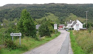
Achmore is a hamlet located close to the south shore of Loch Carron, approximately seven miles east of Plockton near Stromeferry in the historic county of Wester Ross and within the Highland council area, Scotland.

Loch Creran is a sea loch in Argyll, on the west coast of Scotland. It is about 10 kilometres (6.2 mi) long from its head at Invercreran to its mouth on the Lynn of Lorne, part of Loch Linnhe. The loch separates the areas of Benderloch to the south and Appin to the north. The island of Eriska lies at the mouth of the loch. The loch is bridged at its narrowest point at Creagan, by the A828 road. The village of Barcaldine lies on the south shore of the loch.

Loch Alsh is a sea inlet between the isle of Skye in the Inner Hebrides and the Northwest Highlands of Scotland. The name is also used to describe the surrounding country and the feudal holdings around the loch. The area is rich in history, and is increasingly popular with tourists.

Duncraig Castle is a mansion in Lochalsh, in the west of the Scottish Highlands. A category-C listed building, it is situated in the Highland council area, east of the village of Plockton on the south shore of Loch Carron. It was built in 1866 in the Scottish baronial style, to designs by Alexander Ross, for Scottish Member of Parliament and businessman Alexander Matheson. The castle remained in the Matheson family until the 1920s, when it was sold to Sir Daniel Hamilton and his wife Margaret, who owned the neighbouring estate. The Hamiltons intended to use the castle for educational purposes in the local community, but this never came to fruition and following the outbreak of World War II, the castle was used as a naval hospital. By the end of the war, Daniel Hamilton had died, and Margaret bequeathed the castle to the local council, which converted it for use as a home economics college for girls, operating in this capacity until its closure in 1989.

Lochalsh is a district of mainland Scotland that is currently part of the Highland council area. The Lochalsh district covers all of the mainland either side of Loch Alsh - and of Loch Duich - between Loch Carron and Loch Hourn, ie. from Stromeferry in the north on Loch Carron down to Corran on Loch Hourn and as (south-)west as Kintail. It was sometimes more narrowly defined as just being the hilly peninsula that lies between Loch Carron and Loch Alsh. The main settlement is Kyle of Lochalsh, located at the entrance to Loch Alsh, opposite the village of Kyleakin on the adjacent island of Skye. A ferry used to connect the two settlements but was replaced by the Skye Bridge in 1995.


