The national parks of Scotland are managed areas of outstanding landscape where some forms of development are restricted to preserve the landscape and natural environment. At present, Scotland has two national parks: Loch Lomond and The Trossachs National Park, created in 2002, and the Cairngorms National Park, created in 2003.

Loch Lomond is a freshwater Scottish loch which crosses the Highland Boundary Fault, often considered the boundary between the lowlands of Central Scotland and the Highlands. Traditionally forming part of the boundary between the counties of Stirlingshire and Dunbartonshire, Loch Lomond is split between the council areas of Stirling, Argyll and Bute and West Dunbartonshire. Its southern shores are about 23 kilometres (14 mi) northwest of the centre of Glasgow, Scotland's largest city. The Loch forms part of the Loch Lomond and The Trossachs National Park which was established in 2002.

The Stirling council area is one of the 32 council areas of Scotland, and has a population of about 94,330. It was created under the Local Government etc (Scotland) Act 1994 with the boundaries of the Stirling district of the former Central local government region, and it covers most of Stirlingshire and the south-western portion of Perthshire. Both counties were abolished for local government purposes under the Local Government (Scotland) Act 1973.
Luss is a village in Argyll and Bute, Scotland, on the west bank of Loch Lomond. The village is within the Loch Lomond and The Trossachs National Park.

Loch Long is a body of water in Argyll and Bute, Scotland. The Sea Loch extends from the Firth of Clyde at its southwestern end. It measures approximately 20 miles (32 km) in length, with a width of between 1 and 2 miles. The loch also has an arm, Loch Goil, on its western side.

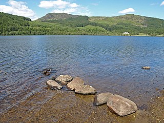
Loch Lomond and The Trossachs National Park is a national park in Scotland centred on Loch Lomond and the hills and glens of the Trossachs, along with several other ranges of hills. It was the first of the two national parks established by the Scottish Parliament in 2002, the second being the Cairngorms National Park. The park extends to cover much of the western part of the southern highlands, lying to the north of the Glasgow conurbation, and contains many mountains and lochs. It is the fourth-largest national park in the British Isles, with a total area of 1,865 km2 (720 sq mi) and a boundary of some 350 km (220 mi) in length. It features 21 Munros and 20 Corbetts.

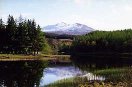
Ben Lomond, 974 metres (3,196 ft), is a mountain in the Scottish Highlands. Situated on the eastern shore of Loch Lomond, it is the most southerly of the Munros. Ben Lomond lies within the Ben Lomond National Memorial Park and the Loch Lomond and The Trossachs National Park, property of the National Trust for Scotland.

The Trossachs generally refers to an area of wooded glens, braes, and lochs lying to the east of Ben Lomond in the Stirling council area of Scotland. The name is taken from that of a small woodland glen that lies at the centre of the area, but is now generally applied to the wider region.
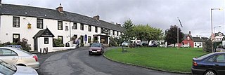
Drymen is a village in the Stirling district of central Scotland. Once a popular stopping place for cattle drovers, it is now popular with visiting tourists given its location near Loch Lomond. The village is centred around a village green which is an unusual feature in Scottish villages but more common in other parts of the United Kingdom.

Crianlarich is a village in Stirling council area and in the registration county of Perthshire, Scotland, around 6 miles (10 km) north-east of the head of Loch Lomond. The village bills itself as "the gateway to the Highlands".

Balloch is a village in West Dunbartonshire, Scotland, at the foot of Loch Lomond.

Tarbet is a small village in Argyll and Bute, Scotland. Located within the Loch Lomond and The Trossachs National Park.
Kilmun is a linear settlement on the north shore of the Holy Loch, on the Cowal peninsula in Argyll and Bute, Scottish Highlands.It takes its name from the 7th century monastic community founded by an Irish monk, St Munn. The ruin of a 12th-century church still stands beside the Kilmun Parish Church and Argyll Mausoleum.

The Falls of Dochart are a cascade of waterfalls situated on the River Dochart at Killin in Perthshire, Scotland, near the western end of Loch Tay. The Bridge of Dochart, first constructed in 1760, crosses the river at Killin offering a view of the falls as they cascade over the rocks and around the island of Inchbuie, which is the ancient burial place of the MacNab clan.
Whistlefield is a hamlet on the east shore of Loch Eck on the Cowal peninsula, Argyll and Bute, West of Scotland. It is home to the Category C listed building, the Whistlefield Inn, which was established around 1801–1804. The hamlet is within the Argyll Forest Park, which is itself part of the Loch Lomond and The Trossachs National Park.
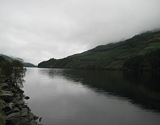
Loch Eck is a freshwater loch located on the Cowal peninsula, north of Dunoon, Argyll and Bute, Scotland. It is seven miles long. Along with Loch Lomond, it is the only naturally occurring habitat of the Powan (fish). The loch also has salmon, sea trout, brown trout and arctic charr.
Loch Chon is a freshwater loch situated west of the village of Aberfoyle, near the small village of Kinlochard, Stirling, Scotland, UK. Loch Chon lies upstream of Loch Ard and to the south of Loch Katrine.
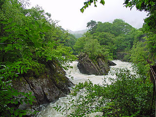
The Falls of Leny are a series of waterfalls in the Trossachs of Scotland on the course of the Garbh Uisge, otherwise known as the River Leny, where the river crosses the Highland Boundary Fault. The falls are located near the Pass of Leny, just north-west of Callander.

The Loch Lomond and Cowal Way is a waymarked footpath through the Cowal peninsula, in Argyll and Bute, between Portavadie on Cowal and Inveruglas on Loch Lomond side. It was formerly known as the Cowal Way, but was renamed in December 2018 to reflect the fact that half of the route lies with the Loch Lomond and The Trossachs National Park. The way is 92 kilometres (57 mi) long, and is suitable for both walkers and mountain bikers. Much of the route is also suitable for experienced horseriders, although in some places steps, narrow footbridges and gates may restrict access for horses. A review to identify these obstacles and suggest alternative routes and/or remedial measures was undertaken in 2016.
The geology of Loch Lomond and The Trossachs National Park in the southwestern part of the Scottish Highlands consists largely of Neoproterozoic and Palaeozoic bedrock faulted and folded and subjected to low grade metamorphism during the Caledonian orogeny. These older rocks, assigned to the Dalradian Supergroup, lie to the northwest of the northeast – southwest aligned Highland Boundary Fault which defines the southern edge of the Highlands. A part of this mountainous park extends south of this major geological divide into an area characterised by younger Devonian rocks which are assigned to the Old Red Sandstone.