Loch Kirkaig

Last updated

Loch Kirkaig
Loch Kirkaig - geograph.org.uk - 1018113.jpg
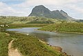
Looking down the length of Loch Kirkaig with the tiny twin islets of Sgeir Mhòr visible in the distance.
Sutherland UK relief location map.jpg
Red pog.svg
Loch Kirkaig
Location Sutherland, Scotland
Coordinates 58°07′35″N5°17′21″W / 58.126347°N 5.289161°W / 58.126347; -5.289161
River sources River Kirkaig
Ocean/sea sources Atlantic Ocean
Basin  countries Scotland
Max. length2.15 km (1.34 mi)
Max. width1.95 km (1.21 mi)
Average depth20 metres (66 ft)
Settlements Inverkirkaig

Loch Kirkaig is a small tidal sea loch, located in the region and parish of Assynt in south-west of Sutherland, in the west coast of Scotland and in the Scottish Highlands. [1] Loch Kirkaig is 1.25 miles south of Loch Inver. The scattered crofting township of Inverkirkaig is located at the headland of the bay, next to the pebbly beach, on the round bay, which has no known name. [2] The name Kirgaig comes from old Norse, Kirkju-vik meaning church bay, perhaps suggesting that in Viking times, there was a church, with a village located in the bay. [3]

Contents

Settlements

Inverkirkaig lies at the head of the sea loch, surrounding a small sand and pebble beach. The principal settlement in the area is the village of Lochinver in Assynt, which is located 2 km northwest of the beach, along the unnamed coast road.

Geography

Loch Kirkaig is bounded by Kirkaig point in the north, and Ribha na Brèige point.

Loch Kirkaig is fed by the River Kirkaig, which drains the lochs of Fionn Loch, Loch Veyatie, Cam Loch Loch á Chapuil, and indirectly Loch nan Ràc, Loch Borralan and Loch Urigill. Travelling in a southeasterly direction along the River Kirkaig through a wooded glen, is the natural wonder and tourist attraction, the 20m Falls of Kirkaig. [4]

The small island of Sgeir Mhòr is located close to the southern coast of the bay.

See also

Related Research Articles

<span class="mw-page-title-main">Loch Fyne</span> Sea inlet on west coast of Scotland

Loch Fyne, is a sea loch off the Firth of Clyde and forms part of the coast of the Cowal Peninsula. Located on the west coast of Argyll and Bute, west of Scotland. It extends 65 kilometres (40 mi) inland from the Sound of Bute, making it the longest of the sea lochs in Scotland. It is connected to the Sound of Jura by the Crinan Canal. Although there is no evidence that grapes have grown there, the title is probably honorific, indicating that the river, Abhainn Fìne, was a well-respected river.

<span class="mw-page-title-main">Suilven</span> Mountain in Highland, Scotland, UK

Suilven is a mountain in Scotland. Lying in a remote area in the west of Sutherland, it rises from a wilderness landscape of moorland, bogs and lochans known as Inverpolly National Nature Reserve. Suilven forms a steep-sided ridge some two kilometres in length. The highest point, Caisteal Liath, lies at the northwest end of this ridge. There are two other summits: Meall Meadhonach at the central point of the ridge is 723 metres (2,372 ft) high, whilst Meall Beag lies at the southeastern end.

<span class="mw-page-title-main">Loch Ard</span> Freshwater loch in grid reference

Loch Ard is a loch, located in Loch Lomond and the Trossachs National Park, Stirling council area, Scotland.

Lochinver is a village at the head of the sea loch Loch Inver, on the coast in the Assynt district of Sutherland, Highland, Scotland. A few miles north-east is Loch Assynt which is the source of the River Inver which flows into Loch Inver at the village. There are 200 or so lochans in the area, popular with anglers. Lochinver is dominated by the "sugar loaf" shape of Caisteal Liath, the summit peak of nearby Suilven.

Achmelvich is a settlement situated in the Highland region of Scotland. The name comes from the Gaelic "Achadh" - a plain or meadow and "mealbhaich" - sandy dunes.

<span class="mw-page-title-main">Canisp</span> Mountain in Scotland

Canisp is a mountain in the far north west of Scotland. It is situated in the parish of Assynt, in the county of Sutherland, 25 kilometres (16 mi) north of the town of Ullapool. Canisp reaches a height of 847 metres (2,779 ft) and qualifies as a Corbett and Marilyn hill. The mountain's name translates from the Old Norse kambsnípa or point of the comb/ridge.

<span class="mw-page-title-main">Loch Inver</span> Sea Loch in grid reference NC

Loch Inver is a 3.62-kilometre-long sea loch in Assynt, Sutherland and is on the northwest coast of Scotland. The loch meets the coastal embayment of Enard Bay at the north end and The Minch, where it meets Soyea Island at its mouth.

<span class="mw-page-title-main">Loch Assynt</span> A lake in Sutherland, Scotland

Loch Assynt is a freshwater loch in Sutherland, Scotland, 8 kilometres (5.0 mi) north-east of Lochinver.

<span class="mw-page-title-main">Loch Veyatie</span> Freshwater loch

Loch Veyatie is a large freshwater loch in north-west Scotland. It stretches for 6 km north-westwards from the settlement of Elphin, and lies between Suilven and Cùl Mòr. The loch is located in an area known as the Assynt-Coigach National Scenic Area, one of 40 such areas in Scotland.

<span class="mw-page-title-main">Inverkirkaig</span> Human settlement in Scotland

Inverkirkaig is extremely remote scattered crofting township, situated on the north eastern bay, of the sea loch Loch Kirkaig, in the Assynt district of Sutherland, Scottish Highlands and is in the Scottish council area of Highland.

<span class="mw-page-title-main">Falls of Kirkaig</span> Waterfall in the Northwest Highlands of Scotland

The Falls of Kirkaig are a waterfall in the Northwest Highlands of Scotland in the county of Sutherland. The fall is located on the River Kirkaig, south by southeast of the village of Lochinver, on the main approach footpath to Suilven mountain. About four miles across the hills to the west is Fionn Loch.

<span class="mw-page-title-main">Badnaban</span> Human settlement in Scotland

Badnaban is a remote scattered coastal village, which lies on the south shore of the sea loch, Loch Inver, in the Assynt district of the west coast of Sutherland, Scottish Highlands. and is in the Scottish council area of Highland.

Strathan is a remote scattered coastal village, located in Bàgh an t-strathain Bay, which lies on the south shore of the sea loch, Loch Inver, in the Assynt district of the west coast of Sutherland, Scottish Highlands and is in the Scottish council area of Highland. Strathan is situated less than 1 mile northeast of Badnaban, 1 mile north of Inverkirkaig, and 2 miles southwest of Lochinver

<span class="mw-page-title-main">Gruinard Bay</span>

Gruinard Bay is a large remote coastal embayment, located 12 miles north of Poolewe, in northwestern Ross and Cromarty, and is in the former parish of Lochbroom, in the west coast of Scotland.

<span class="mw-page-title-main">Kentra Bay</span> Bay in Scotland

Kentra Bay, also known as the Singing Sands, is a remote tidal, 306° orientated, coastal embayment located on the northern shore of the Ardnamurchan peninsula, at the extreme eastern side, where it meets the mainland proper, near Acharacle, in the western Highlands of Scotland. Kentra Bay contains a large expanse of mudflat at low tide and small fragments of salt marsh, sand dune, and machair. Kentra Bay is an inland bay separated from the sea via a channel at the northeast side.

<span class="mw-page-title-main">Enard Bay</span> Large remote tidal coastal embayment in Ross and Cromarty, Scotland

Enard Bay is a large remote tidal coastal embayment, located 10.5 miles northwest of Ullapool, in northwestern Ross and Cromarty, Scottish Highlands in the west coast of Scotland. The mouth of the bay is about 4.5 miles across running from the head of Rubha Mòr peninsula at Rubna Na CòiGeach point to Rubna Na Brèige to the east.

<span class="mw-page-title-main">Loch Culag</span> Freshwater loch

Loch Culag also known as Loch na Doire Daraich is a small freshwater shallow loch, located south of Lochinver in the Assynt district of Sutherland, Highland, Scotland. The loch is located in an area along with neighbouring Coigach, as the Assynt-Coigach National Scenic Area, one of 40 such areas in Scotland.

<span class="mw-page-title-main">Cam Loch, Sutherland</span> Freshwater loch

Cam Loch is an irregularly-shaped freshwater loch, about 5 km long, on a north-west to south-east orientation, located slightly north of the village of Elphin, in the Assynt district of Sutherland, Scotland. The loch is located in an area along with neighbouring Coigach, as the Assynt-Coigach National Scenic Area, one of 40 such areas in Scotland.

<span class="mw-page-title-main">Fionn Loch (Suilven)</span> Freshwater loch

Fionn Loch is a small irregular-shaped shallow freshwater loch, on a north-west to south-east orientation that is located 3 miles southeast of Lochinver in the Assynt district of Sutherland in Scotland. The loch is located in an area known as the Assynt-Coigach National Scenic Area, one of 40 such areas in Scotland.

<span class="mw-page-title-main">Loch a' Mhadail</span> Freshwater loch in NC

Loch a' Mhadail or Loch a' Mhiotailt is a small freshwater lochan that lies immediately to the south-west of Loch Veyatie and is connected by a channel to Loch Veyatie within the area of Inverpolly. The channel measures about 20 foot in length, 10 feet in width and 1 foot in depth. When the water level is low, Loch a' Mhadail is separated from Loch Veyatie by a dyke made of Gneiss.

References

  1. Microsoft; Nokia. "Enard Bay" (Map). Bing Maps . Microsoft. Retrieved 22 November 2017.
  2. "Kirkaig, Loch". The Editors of The Gazetteer for Scotland. School of GeoSciences, University of Edinburgh and The Royal Scottish Geographical Society. 2016. Retrieved 22 November 2017.
  3. "Inverkirkaig". Undiscovered Scotland. Undiscovered Scotland. Retrieved 6 January 2018.
  4. "Kirkaig Falls". Discover Assynt. Assynt Tourism Group. Retrieved 23 November 2017.