Loch Loch

Last updated

Loch Loch
Loch Loch from summit of Ben Vuirich - geograph.org.uk - 1075199.jpg
Loch Loch from the summit of Ben Vuirich
Perth and Kinross UK relief location map.jpg
Red pog.svg
Loch Loch
LocationNN985745
Coordinates 56°51′05″N3°39′53″W / 56.8514°N 3.6647°W / 56.8514; -3.6647
Type freshwater loch
Primary outflows River Tilt
Max. length2.011 km (1.250 mi) [1]
Max. width1.207 km (0.750 mi) [1]
Surface area31.8 ha (79 acres) [2]
Average depth29 ft (8.8 m) [1]
Max. depth81 ft (25 m) [1]
Water volume103,197,000 cu ft (2,922,200 m3) [1]
Shore length14.5 km (2.8 mi) [2]
Surface elevation453 m (1,486 ft) [2]
Max. temperature52.2 °F (11.2 °C)
Min. temperature49.5 °F (9.7 °C)
Islands 0
1 Shore length is not a well-defined measure.

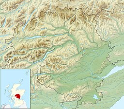
Loch Loch is a remote freshwater loch, located in Glen Loch in Perth and Kinross, some 9.5 miles north of Pitlochry, Scotland and is within the Forest of Atholl. [1] [2]
Geography

Loch Loch is situated in wild mountainous scenery and is located with hills on both sides that have very steep sides. Beinn a' Ghlò is situated to the west side and the precipitous crags of Creag an Loch in the east. Mounds of gravelly moraine form the greater part of both shores, forming the prominent points. The loch flows northward by the An Lochain into the River Tilt, which also receives the water of Loch Tilt at the head of the glen. The loch is on a north to south bearing, and is long and narrow loch, or rather two lochs as there is a narrow constriction in the middle dividing it into two portions.

Related Research Articles

<span class="mw-page-title-main">Gairloch</span> Human settlement in Scotland

Gairloch is a village, civil parish and community on the shores of Loch Gairloch in Wester Ross, in the North-West Highlands of Scotland. A tourist destination in the summer months, Gairloch has a golf course, a museum, several hotels, a variety of shops, takeaway restaurants, a community centre, a leisure centre with sports facilities, a local radio station, beaches and nearby mountains. Gairloch is one of the principal villages on the North Coast 500 route.

Glen Coe is a glen of volcanic origins, in the Highlands of Scotland. It lies in the north of the county of Argyll, close to the border with the historic province of Lochaber, within the modern council area of Highland. Glen Coe is regarded as the home of Scottish mountaineering and is popular with hillwalkers and climbers.

<span class="mw-page-title-main">Beinn Eighe</span> Mountain massif in the Scottish Highlands

Beinn Eighe is a mountain massif in the Torridon area of Wester Ross in the Northwest Highlands of Scotland. Lying south of Loch Maree, it forms a long ridge with many spurs and summits, two of which are classified as Munros: Ruadh-stac Mòr at 1,010 m (3,314 ft) and Spidean Coire nan Clach at 993 m (3,258 ft). Unlike most other hills in the area it has a cap of Cambrian basal quartzite which gives the peaks of Beinn Eighe a distinctive light colour. Its complex topography has made it popular with both hillwalkers and climbers and the national nature reserve on its northern side makes it an accessible mountain for all visitors.

<span class="mw-page-title-main">Trossachs</span> Area of wooded hills and lochs in the southern part of the Scottish Highlands

The Trossachs generally refers to an area of wooded glens, braes, and lochs lying to the east of Ben Lomond in the Stirling council area of Scotland. The name is taken from that of a small woodland glen that lies at the centre of the area, but is now generally applied to the wider region.

<span class="mw-page-title-main">Loch Shiel</span> Freshwater loch in Scotland

Loch Shiel is a freshwater loch situated 20 kilometres (12 mi) west of Fort William in the Highland council area of Scotland. At 28 kilometres long it is the 4th longest loch in Scotland, and is the longest to have retained a natural outflow without any regulation of its water level, being 120 m (393 ft) deep. Its nature changes considerably along its length, being deep and enclosed by mountains in the north east and shallow surrounded by bog and rough pasture in the south west, from which end the 4 km River Shiel drains to the sea in Loch Moidart near Castle Tioram.

<span class="mw-page-title-main">Glen Etive</span> Glen in the Highlands of Scotland

Glen Etive is a glen in the Highlands of Scotland. The River Etive rises on the peaks surrounding Rannoch Moor, with several tributary streams coming together at the Kings House Hotel, at the head of Glen Coe. From the Kings House, the Etive flows for about 18 km, reaching the sea loch, Loch Etive. The river and its tributaries are popular with whitewater kayakers and at high water levels it is a test piece of the area and a classic run.

<span class="mw-page-title-main">Wester Ross</span>

Wester Ross is an area of the Northwest Highlands of Scotland in the council area of Highland. The area is loosely defined, and has never been used as a formal administrative region in its own right, but is generally regarded as lying to the west of the main watershed of Ross, thus forming the western half of the county of Ross and Cromarty. The southwesternmost part of Ross and Cromarty, Lochalsh, is not considered part of Wester Ross by the local tourist organisation, Visit Wester Ross, but is included within the definition used for the Wester Ross Biosphere Reserve.

<span class="mw-page-title-main">Loch Tummel</span> Freshwater loch in Perth and Kinross, Scotland

Loch Tummel is a long, narrow loch, seven kilometres northwest of Pitlochry in the council area of Perth and Kinross, Scotland. It is fed and drained by the River Tummel, which flows into the River Tay about 13 km (8 mi) south-east of the Clunie Dam at the loch's eastern end.

<span class="mw-page-title-main">Lochearnhead</span> Human settlement in Scotland

Lochearnhead is a village in Perthshire on the A84 Stirling to Crianlarich road at the foot of Glen Ogle, 14 miles north of the Highland Boundary Fault. It is situated at the western end of Loch Earn where the A85 road from Crieff meets the A84.

<span class="mw-page-title-main">Beinn a' Ghlò</span> Scottish mountain in the Forest of Atholl

Beinn a’ Ghlò is a Scottish mountain situated roughly 10 km (6 mi) north east of Blair Atholl in the Forest of Atholl in between Glen Tilt and Glen Loch, in Cairngorms National Park.

<span class="mw-page-title-main">Glen Roy</span> Nature reserve in the Highlands of Scotland with ancient shoreline terraces

Glen Roy in the Lochaber area of the Highlands of Scotland is a glen noted for the geological phenomenon of three loch terraces known as the Parallel Roads of Glen Roy. The terraces formed along the shorelines of an ancient ice-dammed loch that existed during a brief period of climatic deterioration, during a much longer period of deglaciation, subsequent to the last main ice age. From a distance they resemble man-made roads running along the side of the glen, hence the name. Much of the glen is designated as a national nature reserve.

<span class="mw-page-title-main">Kintail</span>

Kintail is a mountainous area sitting at the head of Loch Duich in the Northwest Highlands of Scotland, located in the Highland Council area.

<span class="mw-page-title-main">Glen Strathfarrar</span>

Glen Strathfarrar is a glen in the Highland region of Scotland, near Loch Ness.

<span class="mw-page-title-main">Dunalastair Water</span> Freshwater loch, reservoir in Perth and Kinross, Scotland

Dunalastair Water is an entirely man made reservoir in Scotland which lies between Loch Rannoch and Loch Tummel in Strath Tummel in Perth and Kinross council area. The loch provides water power for the Tummel hydroelectricity power station and has the reputation as one of the best wild trout fishing locations in the United Kingdom.

<span class="mw-page-title-main">South Lewis, Harris and North Uist National Scenic Area</span>

South Lewis, Harris and North Uist is a large national scenic area (NSA) in the Western Isles of Scotland. It is one of 40 such areas in Scotland, which are defined so as to identify areas of exceptional scenery and to ensure its protection from inappropriate development. The designated area covers 202,388 ha in total, of which 112,301 ha is on land, with a further 90,087 ha being marine, making it the largest of the NSAs in both total and marine area. The designated area includes the mountainous south west of Lewis, all of Harris, the Sound of Harris and the northern part of North Uist.

<span class="mw-page-title-main">River Garry, Perthshire</span>

The River Garry is a major tributary of the River Tummel, itself a tributary of the River Tay, in the traditional county of Perthshire in the Scottish Highlands. It emerges from the northeastern end of Loch Garry (56.8193°N 4.2311°W), just to the southeast of the Pass of Drumochter, and flows southeastwards and eastwards down Glen Garry to the narrow Pass of Killiecrankie beyond which it joins the Tummel (56.7182°N 3.7790°W).

<span class="mw-page-title-main">Ben Nevis and Glen Coe National Scenic Area</span>

Ben Nevis and Glen Coe is a national scenic area (NSA) covering part of the Highlands of Scotland surrounding Ben Nevis and Glen Coe, in which certain forms of development are restricted. It is one of 40 such areas in Scotland, which are defined so as to identify areas of exceptional scenery and to ensure its protection from inappropriate development. The Ben Nevis and Glen Coe NSA covers 903 km2 (349 sq mi) of land, lying within the Highland, Argyll and Bute and Perth and Kinross council areas. A further 19 km2 (7.3 sq mi) of the NSA are marine, covering the sea loch of Loch Leven.

<span class="mw-page-title-main">Loch Achnacloich</span> A lake in Ross and Cromarty, Scotland

Loch Achnacloich is a very shallow loch located about 4 kilometres (2.5 mi) north of Alness in Ross and Cromarty, Scottish Highlands, Scotland.

<span class="mw-page-title-main">Loch Moraig</span> Freshwater loch

Loch Moraig is a freshwater loch, located 2 miles northeast of Blair Atholl. Loch Moraig was an artificial loch, originally a Snipe marsh, that was dammed in the south, to create the current loch.

<span class="mw-page-title-main">Loch Tilt</span> Freshwater loch in Perth and Kinross

Loch Tilt is a small mountain freshwater loch that sits at the end of Glen Tilt and is located in north-east Perth and Kinross, Scotland. Loch Tilt has a north to south orientation. Loch Tilt is located 10 miles southwest of Braemar.

References

  1. 1 2 3 4 5 6 John, Murray; Lawrence, Pullar (1910). Bathymetrical Survey of the Fresh-Water Lochs of Scotland, 1897-1909 Lochs of the Tay Basin Volume II - Loch Loch. National Library of Scotland: National Challenger Officer. pp. 97–98. Retrieved 19 December 2018.PD-icon.svg This article incorporates text from this source, which is in the public domain .
  2. 1 2 3 4 "Barhapple Loch". British Lakes. Retrieved 19 December 2018.