
Angus is one of the 32 local government council areas of Scotland, a registration county and a lieutenancy area. The council area borders Aberdeenshire, Dundee City and Perth and Kinross. Main industries include agriculture and fishing. Global pharmaceuticals company GSK has a significant presence in Montrose in the north of the county.

The Loch Ness Monster, affectionately known as Nessie, is a creature in Scottish folklore that is said to inhabit Loch Ness in the Scottish Highlands. It is often described as large, long-necked, and with one or more humps protruding from the water. Popular interest and belief in the creature has varied since it was brought to worldwide attention in 1933. Evidence of its existence is anecdotal, with a number of disputed photographs and sonar readings.

Loch is the Scottish Gaelic, Scots and Irish word for a lake or sea inlet. It is cognate with the Manx lough, Cornish logh, and one of the Welsh words for lake, llwch.

The River Ness is a river in Highland, Scotland, UK. It flows from Loch Dochfour, at the northern end of Loch Ness, north-east to the mouth of the Beauly Firth at Inverness, a distance of about 6 miles, with a fall in height of about 16 metres. The river is the origin of the name of Inverness which is from Scottish Gaelic: Inbhir Nis, meaning "Mouth of the Ness".

Loch Lomond is a freshwater Scottish loch which crosses the Highland Boundary Fault, often considered the boundary between the lowlands of Central Scotland and the Highlands. Traditionally forming part of the boundary between the counties of Stirlingshire and Dunbartonshire, Loch Lomond is split between the council areas of Stirling, Argyll and Bute and West Dunbartonshire. Its southern shores are about 23 kilometres (14 mi) northwest of the centre of Glasgow, Scotland's largest city. The Loch forms part of the Loch Lomond and The Trossachs National Park which was established in 2002.

Loch Katrine is a freshwater loch in the Trossachs area of the Scottish Highlands, east of Loch Lomond, within the historic county and registration county of Perthshire and the contemporary district of Stirling. The loch is about 8 miles (13 km) long and 1 mile (1.6 km) wide at its widest point, and runs the length of Strath Gartney. It is within the drainage basins of the River Teith and River Forth.

Loch Maree is a loch in Wester Ross in the Northwest Highlands of Scotland. At 21.7 km (13.46 mi) long and with a maximum width of four kilometres, it is the fourth-largest freshwater loch in Scotland; it is the largest north of Loch Ness. Its surface area is 28.7 km2 (11.08 sq mi).

PS Maid of the Loch is the last paddle steamer built in the United Kingdom. She operated on Loch Lomond for 29 years and as of 2022 is being restored at Balloch pier.

Loch Tay is a freshwater loch in the central highlands of Scotland, in the Perth and Kinross and Stirling council areas. It is the largest body of fresh water in Perth and Kinross, and the sixth largest loch in Scotland. The watershed of Loch Tay traditionally formed the historic province of Breadalbane.
Loch Eriboll is a 16 km (9.9 mi) long sea loch on the north coast of Scotland, which has been used for centuries as a deep water anchorage as it is safe from the often stormy seas of Cape Wrath and the Pentland Firth.
Loch Ericht is a freshwater loch on the border between the former Perthshire, now Perth and Kinross and the former Inverness-shire, now Highlands Council areas of Scotland. It has a north-east to south-west orientation. The village of Dalwhinnie lies at the north east end of the loch. Loch Ericht is the tenth largest freshwater lake in Scotland and has a good reputation for its trout fishing and Ferox trout.
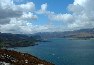
Loch Carron is a sea loch on the west coast of Ross and Cromarty in the Scottish Highlands, which separates the Lochalsh peninsula from the Applecross peninsula, and from the Stomeferry headland east of Loch Kishorn. It is the point at which the River Carron enters the North Atlantic Ocean.
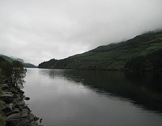
Loch Eck is a freshwater loch located on the Cowal peninsula, north of Dunoon, Argyll and Bute, Scotland. It is seven miles long. Along with Loch Lomond, it is the only naturally occurring habitat of the Powan (fish). The loch also has salmon, sea trout, brown trout and arctic charr.
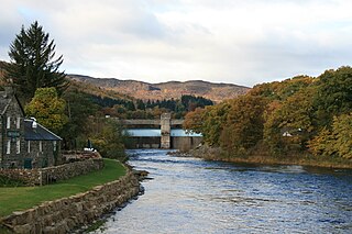
The Tummel hydro-electric power scheme is an interconnected network of dams, power stations, aqueducts and electric power transmission in the Grampian Mountains of Scotland. Roughly bounded by Dalwhinnie in the north, Rannoch Moor in the west and Pitlochry in the east it comprises a water catchment area of around 1,800 square kilometres (690 sq mi) and primary water storage at Loch Ericht, Loch Errochty, Loch Rannoch and Loch Tummel, in Perth and Kinross. Water, depending on where it originates and the path it takes, may pass through as many as five of the schemes nine power stations as it progresses from north-west to south-east. The scheme was constructed in the 1940s and 50s incorporating some earlier sites. It is currently managed by SSE plc.
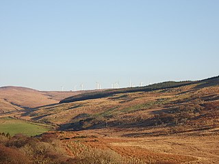
Beinn an Tuirc wind farm is a wind farm in Argyll, Scotland.

Loch Ness is a large freshwater loch in the Scottish Highlands extending for approximately 37 kilometres southwest of Inverness. It takes its name from the River Ness, which flows from the northern end. Loch Ness is best known for alleged sightings of the cryptozoological Loch Ness Monster, also known affectionately as "Nessie". It is one of a series of interconnected, murky bodies of water in Scotland; its water visibility is exceptionally low due to a high peat content in the surrounding soil. The southern end connects to Loch Oich by the River Oich and a section of the Caledonian Canal. The northern end connects to Loch Dochfour via the River Ness, which then ultimately leads to the North Sea via the Moray Firth.

The Cruachan Power Station is a pumped-storage hydroelectric power station in Argyll and Bute, Scotland. The scheme can provide 440 MW of power and produced 705 GWh in 2009.

